A portrait of the past: What is the Archaeological Atlas of France?
Unlike most histories of a country, the 'Archaeological Atlas of France' does not include Kings, Presidents, revolutions or great battles.
Instead, it recounts thousands of years of human occupation, including enormous changes in France's borders, its climate, population and the way of life of its inhabitants.
100 new maps were created from the findings of thousands of excavations over the past two decades.
What was discovered in the soil provided clues about human societies who either buried items themselves, for example in tombs, or simply by the passage of time.
Published by Inrap, the National Institute for Preventive Archaeological Research, in November, the Atlas sold out and has recently been reissued.
“Most often, what reaches the general public is what is visible and preserved. We want to show the invisible heritage beneath our feet,” explained Inrap President, Dominique Garcia.
The maps point to knowledge but “also blank areas” to “questions" he added.
Origin story
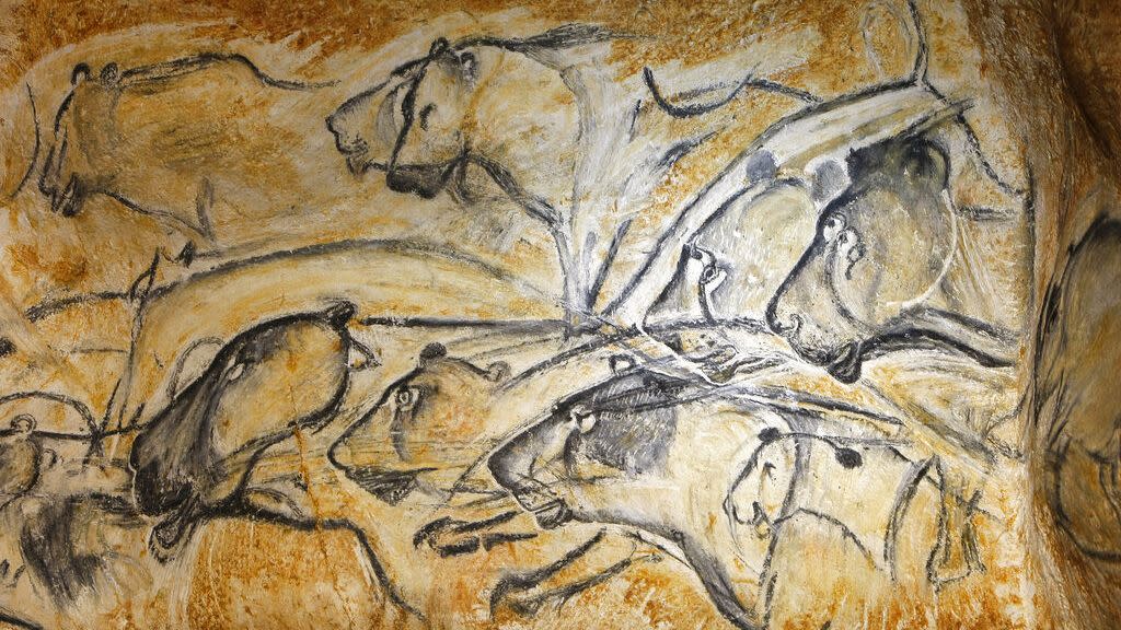
The Atlas begins with a map of Africa and is followed by the arrival of Homo Sapiens into what is now France, tracing their first artistic works. It ends with the Second World War and a passage through colonial and overseas France.
One section of the Atlas focuses on the archaeology of Guyana (1795-1953) studying its history of slavery, as a penal colony and gold panning.
Garcia explained that the authors wanted to “show the overseas space for what it is in its own history, and not only from the moment France set foot there".
The soil archives
Each map represents a layer of France's past and is accompanied by a summary, photos, plans and artists' views to portray landscapes that have since disappeared.
It is divided into major periods and themes looking at the agricultural, artisanal, funerary and commercial practices that the soil archives reveal.
The Atlas also shows how socio-economic and cultural processes fit together, whether through carved stones, statues, ceramics and necropolises, or once living elements, such as skeletons or consumed remains like fauna and seeds.
Topics include the circulation of precious objects in the Neolithic period, such as alpine jade axes found as far as the tip of Brittany, changes in the cremation practices in the Bronze Age, or the spread of the plague between 1347 and 1351, which is remarkably reminiscent of the Covid-19 pandemic map.
It also looks at contemporary issues, from the management of epidemics, climate changes and the development of cities.
A History of Archaeological Maps
The first attempt at archaeological cartography on this scale was carried out between 1858 and 1879 by the Commission de Topographie des Gaules (CTG).
In 1858, the CTG’s objective was to produce three maps of Gaul, one from the Celtic period before the Roman conquest; the second, from the Gallo-Roman period; and the third, during the Merovingian period.
The project as it was initially conceived did not come to fruition. While all the maps were completed, only one part of the 'Dictionnaire archéologique de la Gaule – Époque Celtique' was published between 1875 and 1878.
A 2001 law which aimed at preserving buried heritage through excavations before work to develop the land began, sped up the mapping process.
The Archaeological Atlas of France now synthesises excavation data from as far back as the 19th century.
The story of wine in Gaul
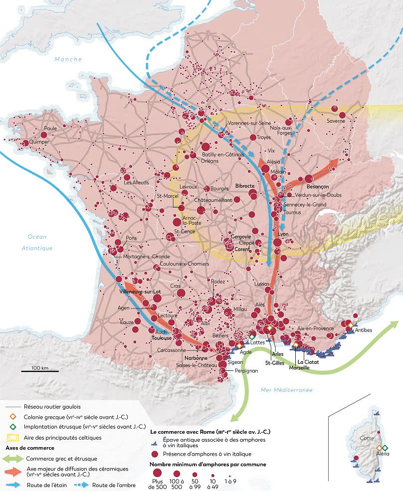
The Mediterranean and Gallic wine map demonstrates how Gallic territory on the tin and amber route attracted Mediterranean, Greek, Etruscan, Phoenician and Roman merchants, who set up trading posts and colonies from the end of the seventh century BCE.
Along the coast of southern Gaul numerous high-value manufactured products, such as Attic ceramics, ornaments and Greek wine amphorae, were discovered dating from the end of the First Iron Age. This suggests a boom in exchanges between indigenous populations and Mediterranean traders.
Following Rome's victory over Carthage at the end of the Second Iron Age, Romans developed their commercial network in the western Mediterranean and further north.
In Gaul, they found raw materials (metals and salt), slaves, and raw or processed agricultural products which they exchanged for wine coming mainly from the Tyrrhenian coast (Etruria, Lazio, Campania) and some tableware.
Wine amphoras were transported from the ports of Mediterranean Gaul to their northern territories via the Garonne, Rhône and Saône rivers.
The second half of the third century BCE brought a warmer and drier climate called the “Roman climatic optimum”. This enabled an increase in agricultural production in non-Mediterranean Gaul.
Large rural estates, owned by the Gallic elite, produced surpluses which could be exchanged for imported products, especially wine, an important part of banquets, large community gatherings and certain religious ceremonies.
Wine had previously only been cultivated in the Gallic territory of Marseille before the Roman Conquest.
