Polar vortex plunging into the U.S.: Get ready for dangerous cold

A pinwheeling section of the polar vortex is clearing customs at the Canadian border, heading for the northern Plains, Midwest, Mid-Atlantic and Northeast U.S. For millions, this may be the coldest December weather in at least a decade.
On Thursday, temperatures may not rise above the low single digits Fahrenheit in Chicago, with any winds making for dangerous wind chill temperatures.
SEE ALSO: Polar vortex about to blast U.S. with coldest air of the season
By Thursday and Friday, the ultra-cold air will push east behind a series of cold fronts. These frontal systems will drag cold air southeastward and cause northwesterly winds to howl across the Mid-Atlantic and Northeast.
This will make the air temperatures feel even more miserable on Thursday and Friday.
High temperatures in the 20s to 30s Fahrenheit on Thursday from Boston to Washington, combined with winds gusting more than 30 miles per hour, will set the stage for the coldest night of the year so far for the big cities on the East Coast.
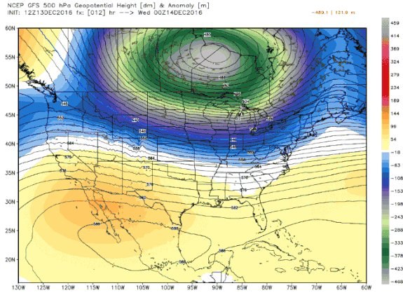
Image: weatherbell analytics
Some spots may approach daily record lows, although widespread record-setting cold is not expected. Temperatures across parts of the Midwest and East Coast are likely to range from 15 to 30 degrees Fahrenheit below average for this time of year.
The lack of records for the big cities of the East will partly be because there is not an extensive snowpack along the coastal plain, with most of the snow having fallen so far in northern and central New England and the traditional lake effect zones downwind of the Great Lakes.

Image: weatherbell analytics
Nevertheless, it's still going to feel extremely cold on Thursday and Friday.
As an indication of what's coming to the East on Thursday and Friday, consider that on Tuesday morning, subzero lows were recorded in Iowa and Nebraska, and wind chills dropped to the mid-30s below zero Fahrenheit in Minnesota.
However, the snowpack in those areas is helping accentuate the cold, since it enhances radiational cooling, keeping day and nighttime temperatures lower.
New York City, for example, could see a low temperature of about 11 degrees Fahrenheit on Friday morning. This air temperature, combined with winds out of the northwest at 20 to as high as 30 miles per hour, would lead to wind chills of 0 to minus-15 degrees Fahrenheit.
However, a low of 11 would not be enough to tie or set a record in New York City on Friday morning, given that the record for that date is 7 degrees Fahrenheit, set way back in 1876.
New York's Kennedy International Airport could set a record, with a forecast low of 16 from the National Weather Service, and a record low of 15 from 1961.
The suburbs of Washington, Philadelphia and New York may see air temperatures dip below zero on Friday morning.
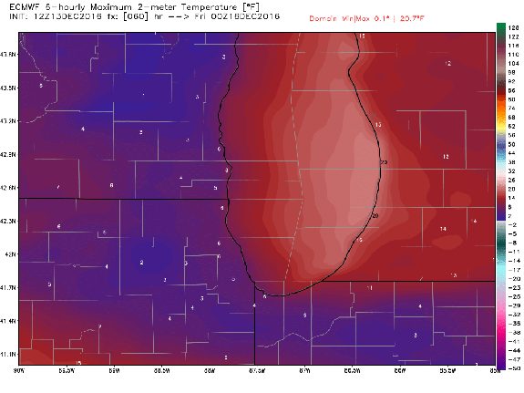
Image: weatherbell analytics
According to the Capital Weather Gang blog, Washington D.C. hasn't experience a day that failed to get out of the 20s Fahrenheit since 2010.
And the last December to have two straight days with highs in the 20s in D.C. was in 2000. The blog reported that the last day that was compared to the temperatures forecast for Friday was Dec. 20, 2004, when the high was 24 and the low was 11 degrees Fahrenheit.
While the cold with this event will be significant, it will be short-lived for many areas. The more sustained cold during the rest of December looks to be across the Midwest, West and Pacific Northwest, with periodic swipes of cold whipping eastward.
So, while the East will warm back up for the weekend, the Midwest and Plains states will see a renewed Arctic blast, with dangerously cold wind chills affecting NFL games. In fact, some Midwestern cities may not see the temperature go above freezing for up to 2 weeks.
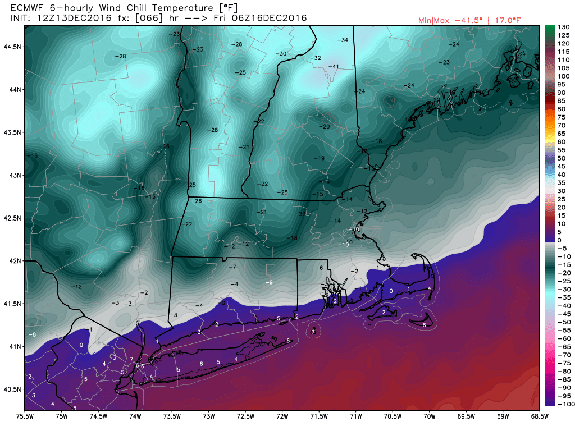
Image: weatherbell analytics
It remains to be seen whether that renewed cold snap makes its way to the East Coast for round two of extreme cold.
About that polar vortex
Although the term can seem to be overused, or somehow made up, rest assured: It's both a real phenomenon and applicable to these waves of cold air.
The main polar vortex is a circulation of air enveloping a near-permanent area of low pressure that exists in the upper atmosphere, above typical cruising altitudes for commercial jetliners, over the Arctic.
When these winds weaken, as has been happening recently, filaments of the vortex can break off, and meander south into the U.S., Europe and parts of Asia. Last month, parts of the vortex set up shop over Siberia, causing exceptionally cold and snowy conditions there while driving unusually mild air into the Arctic and melting sea ice.
Now, some of that Siberian cold is headed for Canada and the U.S., with the assistance of a massive ridge of high pressure across Alaska and the North Pacific Ocean. That high pressure area is drawing Arctic air southward on its eastern flank.