Photos: Storms unleash damaging winds and large hail across Ohio, Tennessee valleys
Three people were injured after severe weather tore from Indiana to Kentucky and Tennessee to end the week.
The severe storms were triggered by the same system that spawned a devastating tornado in Iowa and high winds in Branson, Missouri, on Thursday.
One firefighter suffered a minor injury and over a dozen homes were damaged near New Middletown, Indiana, on Friday when a tornado-warned thunderstorm moved through the area.
Based on video evidence, the National Weather Service confirmed a tornado occurred in the town, according to the Courier-Journal. A survey team determined that it was an EF-1 tornado that caused the damage.
New Middletown is located approximately 15 miles southwest of Louisville, Kentucky.
Ind. State Police reports tornado damage to about 20 homes in New Middletown area of Harrison Co., Ind. One minor injury to a firefighter. Updates @WDRBNews at 6 p.m. pic.twitter.com/uwu0NbLIaN
— Chris Turner (@ChrisTurnerWDRB) July 20, 2018
A tornado was also reported in Madison County, Indiana, with reports of a barn destroyed near Moonville.
In Norwood, Ohio, and Michigan City, Indiana, two people were treated for injuries sustained from fallen trees.
Over 100,000 people were left without power in Kentucky after the severe weather blew through.
Wind gusts reached 70 mph at a weather observation station at Blue Grass Airport in Lexington, Kentucky, on Friday afternoon.
@ShawnReynolds_ Crazy clouds and storm rolling into the East End of Louisville!! pic.twitter.com/JQmIh5zNga
— Jeff Pile (@Jeff_Pile) July 21, 2018
Pictures on social media showed streets and yards littered with leaves, tree branches and fallen trees throughout the region.
In addition to the widespread damaging winds, massive hailstones were also reported.
WOW: Check out the hail that just fell in Tompkinsville, Ky! #SkyWatch17
If safe to do so, share pics here: https://t.co/T4ClM4o61E
Photos: Amy Arnett pic.twitter.com/s7VuT282Fi— FoxNashville (@FOXNashville) July 21, 2018
In Tompkinsville, Kentucky, hail with a diameter of 4 inches, which is equivalent to a grapefruit, was reported.
A check of the archives shows the Tompkinsville hail report yesterday is not a state record. On 4/23/68, 5" diameter hail was reported in Harlan Co. Several locations in KY had 4.5" (grapefruit) hail on 5/1/2002. #kywx
— NWS Louisville (@NWSLouisville) July 21, 2018
Hail sizes ranging from golf balls to baseballs were also common across the area.
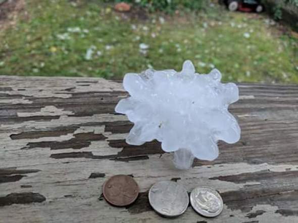
Large hail in Madison, Indiana, on Friday afternoon. (Photo/Teresa Kelly)
Some more shots of the tornado damage south of New Middletown, Indiana. @WLKY @840WHAS #inwx pic.twitter.com/mlTfOUsqVW
— Will Clark (@WClark840WHAS) July 20, 2018
Highs winds knocked over a large tree that took a power line down behind this four-plex in Franklin Co. The live power line provided an arc which led to a large fire that did extensive damage to this home. No one was injured. @WKYT @Kentuckyweather #kywx pic.twitter.com/6bUHvuj8fW
— Chris Johnson (@ChrisWKYT) July 20, 2018
Major damage in Silver Lake following today's storms. There's four cars under that tree pic.twitter.com/wGwZ3Koa6R
— Megan Smedley (@Megan_WNDU) July 20, 2018
Hail from the storms that passed over pewee valley/ Crestwood area earlier this evening #kywx pic.twitter.com/pluGVFbFqP
— KCleveland (@canada_02) July 21, 2018
More storm damage photos from Lexington. @NWSLouisville lots of 12"+ breaks. pic.twitter.com/0A7xWLttvh
— W700 Weather Inc. (@TeamW700) July 21, 2018
@NWSLouisville Significant tree damage along Steele Road and McCracken Pike #kywx pic.twitter.com/QspRpJ8pis
— James Perkins (@Yamezzie) July 20, 2018
