Photos: Severe storms leave over 200,000 without power from Missouri to Alabama
Severe thunderstorms tore from the mid-Mississippi Valley to the Gulf Coast on Thursday, leaving an extensive trail of damage in their path.
The storms were fueled by the intense heat and humidity that continues to build across the eastern half of the country.
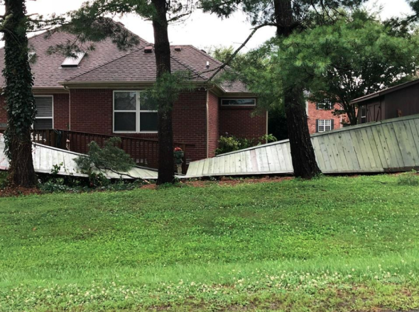
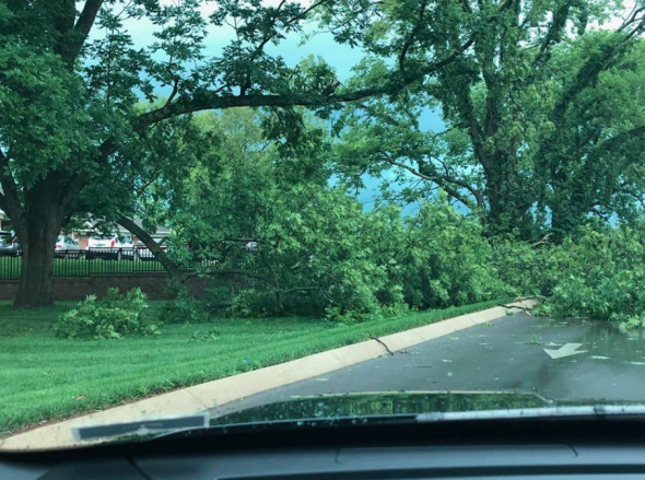
Most of the damage inflicted was caused by straight-line winds.
However, one tornado was confirmed in Hickman County, Tennessee. The tornado was rated an EF1 with estimated peak winds of 110 mph.
This house was destroyed as storms blew through Hickman County today- @NWSNashville is currently surveying the damage. #tnwx @nc5 pic.twitter.com/aVfDATVlbU
— Bree Smith (@NC5_BreeSmith) June 28, 2018
Wind gusts up to 60 mph were common from eastern Missouri and southwest Illinois through western Tennessee and a large swath of Alabama.
At Lambert International Airport in St. Louis, a wind gust of 51 mph was recorded around 5:30 p.m. CDT. The metro area was under a tornado warning for a time, but no tornado was confirmed.
The high winds easily snapped trees and power lines, leaving over 200,000 people without power during the height of the storms.
There are now nearly 1/4 million customers without power in Missouri, Illinois and Alabama due to severe thunderstorms downing trees & lines today. pic.twitter.com/Qy4PXarxSD
— Jesse Ferrell (@Accu_Jesse) June 29, 2018
Nearly 200,000 customers were left without electricity in Alabama alone, according to Alabama Power.
In Huntsville, Alabama, a 70-year-old woman was struck by lightning during the severe weather on Thursday afternoon, according to WHNT News. The woman remains in critical condition.
As cleanup efforts begin and crews work to restore power, intense heat and sweltering humidity will remain locked over the region.
Those who remain without power should spend time in public buildings that have air conditioning to cool down and help prevent heat-related illnesses. Crews working outside will want to wear light-colored, loose-fitted clothing and stay properly hydrated.
Additional showers and heavy, gusty thunderstorms into Saturday may also hamper restoration work across the Southeast. However, a repeat of the magnitude of Thursday's severe event is not expected.
Storm damage in central Tennessee on Thursday. (Facebook photo/Columbia, TN, Police Department)
#tristatewx #ilwx @NWSPaducah June 28, 2018: Carl White photographer. Carterville, IL after the storm. pic.twitter.com/AM5jCADDHS
— Beau Dodson (@BeauDodson) June 29, 2018
Tree on house on Keener Drive in Leesburg #alwx pic.twitter.com/hUl1ScNHI0
— Cherokee County EMA (@cherokee_ema) June 28, 2018
Wind damage at the Lewisburg O'Rilley's Autoparts store #tnwx pic.twitter.com/mQCaE94ZPE
— Katy Morgan (@katymorganwx) June 28, 2018
Tree branch pierced a car windshield in Homewood courtesy CBS 42 viewer Rahab Thairu #alwx Downed trees, road conditions and live radar: https://t.co/wwjOvuGiS7 pic.twitter.com/QIw3X2m98G
— CBS 42 (@CBS_42) June 28, 2018
Tree on house on Armstrong Rd. Cedar Bluff. #alwx pic.twitter.com/TzYlXAZHsm
— Cherokee County EMA (@cherokee_ema) June 28, 2018
Severe storms downed trees in central Tennessee on Thursday. (Facebook photo/Columbia, TN, Police Department)
Beautiful sunset and mammatus clouds after the storm here at the office. #mowx #ilwx #stlwx pic.twitter.com/ht6Vc9nNiQ
— NWS St. Louis (@NWSStLouis) June 29, 2018
