PHOTOS: More eruptions and lava flows as blue flames burn at Kīlauea Volcano
A third Kīlauea lava flow reached the ocean on Thursday, according to the United States Geological Survey (USGS).
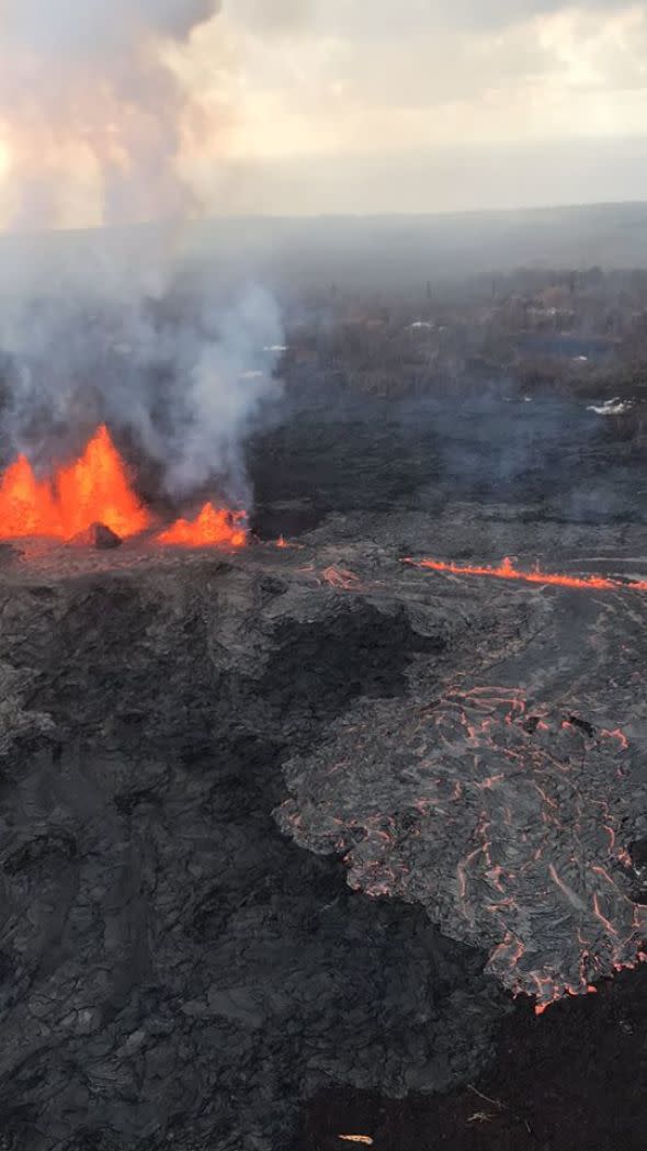
Fissures 7 and 8 remain the most active. The USGS reported that on Sunday a fast-moving lava flow broke from this area and advanced through the eastern portion of Leilani Estates. Fissure 13 remains the most prominant source for lava entering the ocean.
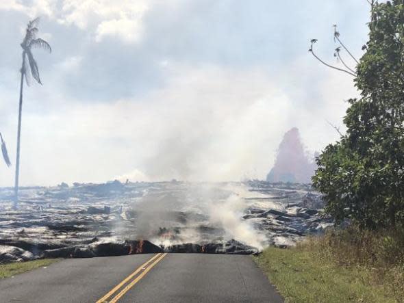
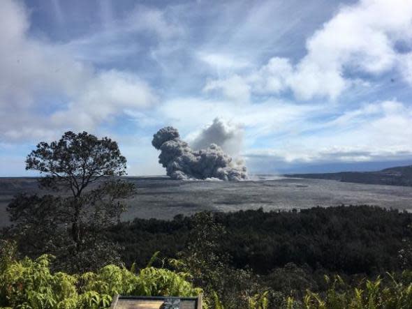
On Saturday, crews reported "fast and fluid lava flows" from some fissures and "robust activity" from others. Multiple small eruptions of ash occurred on Friday, with one of the largest sending ash as high as 12,000 feet above sea level.
U.S. Marine Corps stationed in Hawaii are now on standby to help with evacuations should a lava flow reach State Highway 130, thus blocking residents of Leilani Estates from reaching schools, stores and hospitals.
Lava fissure 7 was very active on Sunday, reported the Hawaii Volcano Observatory (HVO).
This lava flow crossed into the Puna Geothermal Venture (PGV) property on Saturday night and covered at least one well Sunday, the Hawaii County Civil Defense Agency reported.
The well was plugged in anticipation of the lava flow in order to protect against the release of gas that could turn toxic when mixed with lava. Hydrogen sulfide levels are being monitored, but officials stress that the gas has not been detected.
Volcanic gas emissions remain very high from the fissure eruptions.
HVO reports that an ash eruption at the Kīlauea summit occurred on Friday at about 4:17 p.m. HST. The eruption caused an ash plume that reached 12,000 feet high, but that cloud quickly disperse. Another eruption sent more ash to 10,000 feet on Friday night.
"Additional explosive events that could produce minor amounts of ashfall downwind are possible at anytime," according to HVO.
"How large the eruption is will determine where the ash cloud will head," AccuWeather Senior Meteorologist Kristina Pydynowski said.
While the dangers of laze and vog have been confined to the southwest of the volcano recently, that may change early this week.
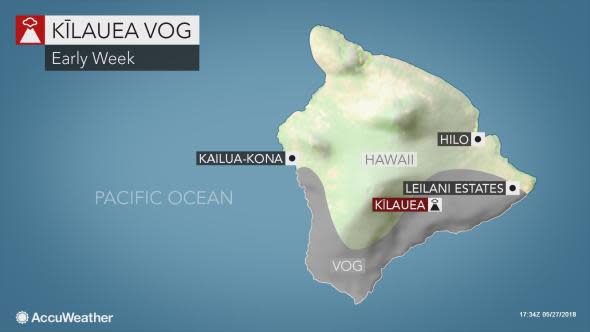
"If winds become southeasterly for a time into Tuesday, there is a chance the vog may reach other parts of the Big Island and, possibly, even the smaller islands of Hawaii," Pydynowski said.
On Wednesday, blue flames appeared near the volcano due to methane that is produced when hot lava buries and burns plants and trees, according to the Associated Press.
HVO warns that eruption activity can change at any moment and asks that residents remain aware and be prepared in order to respond to changing conditions.
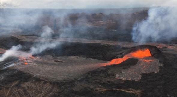
Fissure 7 viewed from a helicopter overflight Sunday morning around 9 a.m. HST, showing the line of "mini fissures". (Photo?USGS)
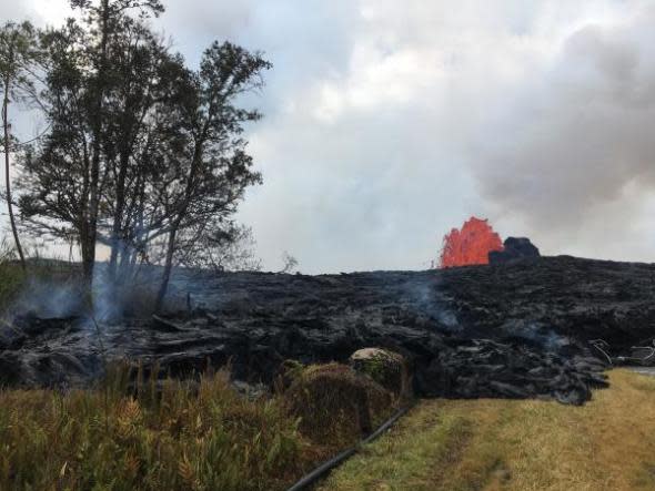
Pāhoehoe lava advancing west from fissure 7 (lava fountain in background) on Leilani Avenue. Fissure 7 activity increased overnight, with lava fountains reaching 50 to 60 m (164 to 197 ft) high. (Photo/USGS)
View of a rising ash plume from Halema‘uma‘u, a crater at the summit of Kīlauea, on May 24, 2018, as seen from the caldera rim near Volcano House. USGS scientists are stationed at this vantage point to track the ongoing summit explosions. (Photo/USGS)
Activity at fissure 6 on May 25, 2018. Lava fountains have built a small spatter cone (black mound) from which lava was spilling out onto the surface and flowing into a small pond (left of the cone). (Photo/USGS)
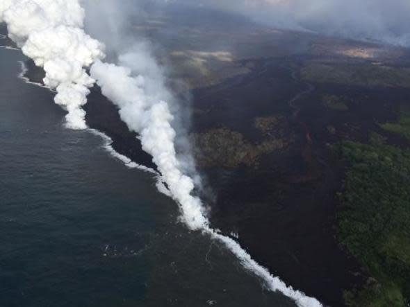
Aerial view of the active ocean entries at Kīlauea Volcano's lower East Rift Zone captured during this morning's HVO overflight. An ongoing hazard at the ocean entries is laze. As hot lava boils cool seawater, a series of chemical and physical reactions create a mixture of condensed acidic steam, hydrochloric acid gas, and tiny shards of volcanic glass. Blown by wind, this plume creates a noticeable downwind haze, known as "laze" (short for lava haze). Laze is irritating to the lungs, eyes and skin. (Photo/USGS)
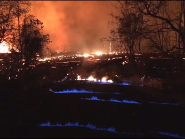
This photo released Wednesday, May 23, 2018 by the U.S. Geological Survey shows blue burning flame of methane gas was observed in the cracks on Kahukai Street, during the overnight hours. The volcano produces methane when hot lava buries and burns plants and trees. Scientists say the methane can seep through cracks several feet away from the lava. (Photo/USGS)
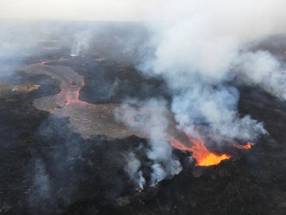
During HVO's overflight on the morning of May 24, the fissure 22 fountain was not as high as several days previous, but was still erupting significant lava. (Photo/USGS photo by M. Patrick)
Fissure 6 fountain, as of around 9:30 a.m. HST on May 24. (Photo/USGS photo by M. Patrick)
On May 23, 2018, the Hilo Civil Air Patrol captured this evening photograph of the coastline where lava flows are entering the sea. There are currently three primary ocean entry points, which have evolved over the course of the eruption. (Photo/J. Ozbolt)
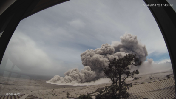
Poor weather at the summit of Kīlauea has obscured views of Halema‘uma‘u for much of today, but a brief break in the weather around noon allowed HVO's webcam to capture this image of an ash plume rising from the crater at 12:17 p.m. HST. Even though weather has obscured visual observations of the ongoing summit explosions, HVO scientists are able to track them using signals from monitoring instruments, such as seismometers. (Photo/USGS)

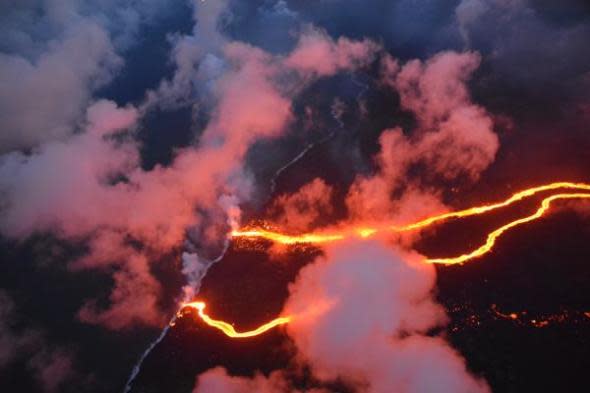
During a May 24 overflight of the ongoing lower East Rift Zone eruption, HVO geologists noted that fissures six, 13 and 22 were still erupting. The eastern lava channel splits just before reaching the ocean, so it has two entry points, creating a total of three ocean entries on the flow field. (Photo/M. Patrick)
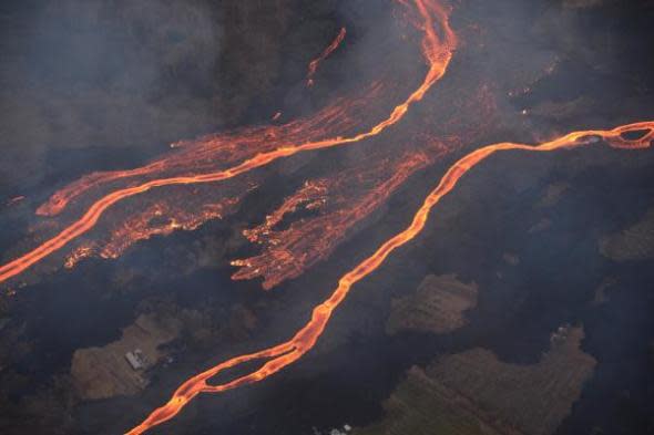
On Wednesday, May 23, the Hilo Civil Air Patrol conducted flights over the lower East Rift Zone eruption to assist USGS and Hawai‘i County Civil Defense Agency as they respond to the Kīlauea eruption. This image shows the scale of the lava channels feeding the ocean entries. Note that lava is overflowing the channels and is on top of slightly older, black lava flows. The visible haze is sulfur dioxide gas that's being emitted from the fissures. (Photo/J. Ozbolt)
