Will Pensacola feel the South Florida heat wave? No, but high temps still expected
South Florida is under excessive heat warnings this week, as forecasted by the National Weather Service (NWS) on Monday.
The Palm Beach International Airport reported a new record of 98 degrees on Wednesday and more record breaking heat is expected to last the rest of the week.
The Florida Panhandle won’t get a taste of the heat wave impacted South Florida, but the National Oceanic and Atmospheric Administration (NOAA)’s latest three-month temperature outlook isn’t painting a pretty picture for the vast majority of the United States.
What kind of weather can Floridians expect for the next three months? A hot and wet summer.
El Niño continues its neutral transition; La Niña conditions still expected later this summer
El Niño conditions remain in effect, but atmospheric and oceanic weather patterns show that the effects are waning. There are even chances for El Niño Southern Oscillation neutral or La Niña conditions to occur between June and August.
The chances for a La Niña transition increase to almost 70% from July through September.
La Niña happens when Pacific waters cool, moving the location where deep tropical thunderstorms form in the Pacific so that the wind shear in the Atlantic Ocean wanes during summer and fall. In winter, La Niña pulses storms into the Pacific Northwest on a more northerly and inland track, holding the jet stream at higher latitudes longer where it traps cold air to its north.
Impending La Niña conditions are a big part of why meteorologists are expecting the 2024 Atlantic hurricane season to be historic.
Hurricane season: 2024 will be a busy hurricane season in Florida. Here's what you should start doing now
The ingredients combining for a robust year include a rising La Niña and water temperatures in the runway between Africa and the Gulf of Mexico that are 3.6 to 7 degrees warmer than normal — a buffet of fuel for burgeoning systems.
At least one forecast points to a healthy African jet stream that could churn out tropical waves like a conveyor belt on warp speed. Another is already considering that the season could extend past its normal expiration date as in 2005 when Hurricane Epsilon formed in December.
“I’m looking for some ray of sunshine in this forecast and I don’t see it,” Weather.com senior meteorologist Jonathan Erdman told the Palm Beach Post. “This has all the makings of a potentially historic hurricane season.”
Florida’s summer looks hot. And wet.
Florida, along with the overwhelming majority of the U.S., is expected to see above-normal temperatures, according to strong decadal temperature trends and the lesser impacts of a potential La Niña.
NOAA’s latest seasonal temperature outlook shows a 40-50% chance of above normal temperatures for much of the southeast, east and western parts of the country. Many other parts of the country are expected to see even higher chances of above normal temperatures, with a 60-70% chance in Arizona, New Mexico, the western southern tip of Colorado, Utah and the western tip of Texas.
Must of Florida is also expected to see above normal chances of precipitation over the next three months. South Florida has a slightly lower chance compared to the rest of the state.
What is NOAA’s monthly climate lookout?
NOAA releases monthly climate outlooks on the third Thursday of the month that tries to predict three possible outcomes: above-average, near-average, or below-average monthly mean temperature or total precipitation.
How does NOAA determine what is above or below average?
NOAA is careful when quantifying what is considered above or below average. Above-average temperatures or precipitation must be in the upper one-third of values observed between 1991-2020 for a given month. Below-average temperatures or precipitation must be in the lower one-third.
To help readers better understand what these indicators mean, NOAA will often include language like “well above or below average” or “much wetter or drier than average.”
NOAA’s seasonal climate outlook map for June-July-August 2024
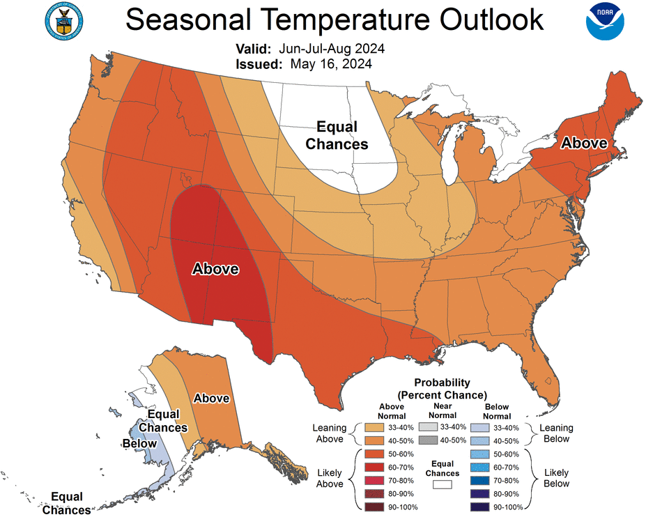
How to read the map
NOAA’s monthly climate outlook maps look simple but can occasionally be tricky to navigate. Here’s how to interpret it.
White areas
Areas represented in white mean there are equal chances for all three possible outlook categories: well above average, near average and well below average. This means that white areas do not represent an average or typical month.
Blue areas
Areas represented in blue signal that the Climate Prediction Center anticipates a much cooler-than-average month rather than a near-average or much warmer-than-average month. Darker hues indicate that the chances for a relatively cold month are higher — not an indicator of extreme cold.
Orange/red areas
Areas represented in orange are more likely to be much warmer than a near-average or much cooler-than-average month. Darker hues indicate that the chances for a relatively warm month are higher — not an indicator of extreme heat.
This article originally appeared on Pensacola News Journal: Florida heat wave won't impact panhandle, but this summer will heat up

