What is the path of Tropical Storm Sally? It could hit the U.S. coast as a hurricane
The National Hurricane Center has issued an alert for residents of the northern Gulf Coast given the projected path of Tropical Storm Sally, which formed Saturday afternoon about 35 miles southeast of Naples, Florida.
People in New Orleans, Biloxi and Florida’s Panhandle, including Panama City, should monitor the progress of the system, which turned into a tropical storm a bit faster than projected, with maximum sustained winds of 40 mph at 2 p.m. Saturday, according to the National Hurricane Center.
Tropical Storm Sally is projected to hit somewhere along the Mississippi Coast as a hurricane by Tuesday morning.
Tropical storm or hurricane watches, and storm surge watches, could be issued for a portion of those areas later Saturday.
Satellite-derived wind data indicate that Tropical Storm #Sally has formed and is centered just off the southwest coast of Florida. Maximum sustained winds are 40 mph. https://t.co/wVCrCIjDrB pic.twitter.com/KC7Bq1Vror
— National Hurricane Center (@NHC_Atlantic) September 12, 2020
Landfall made in South Florida
Before its upgrade, Tropical Depression 19 made landfall near Blackpoint Marina in South Miami-Dade’s Cutler Bay Saturday morning as the system sliced across South Florida, dumping more than 10 inches of rain in the Florida Keys’ Islamorada and flooding parts of the Overseas Highway.

Tropical Storm Sally moves away from South Florida. Is expected to become a Gulf hurricane
Forecast track
On its current forecast track, the soggy system, just off the southwest coast of Florida, will likely be a strengthening tropical storm in the Gulf as it slows from its recent 7 mph westerly motion to gather energy from the warm waters as it approaches the U.S. coastline beginning Monday around 8 a.m.
On the forecast track, the center is forecast to move over the southeastern and eastern Gulf of Mexico later Saturday and Sunday, and then move over the north-central Gulf of Mexico Sunday night and Monday.
Tropical Storm Sally could also move onto land somewhere in Louisiana, which was recently battered by Hurricane Laura, or Mississippi, Alabama or Florida’s Panhandle Monday morning.

By Tuesday morning and the middle of the week, tropical storm-force winds could extend anywhere from parts of Texas to Georgia and farther north into Arkansas.
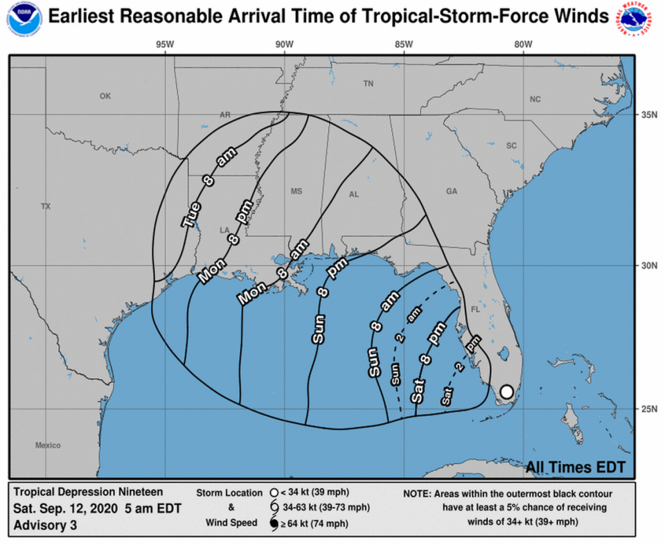
According to the National Hurricane Center, Sally is expected to dump three to six inches of rain, with localized amounts of eight inches, along the Gulf Coast from the Florida Peninsula to southeast Louisiana and two to four inches farther inland over far southern Alabama, Mississippi and southeast Louisiana by Tuesday.
The track will become clearer once Sally is over open water in the Gulf and its center solidifies over the next day or so, the hurricane center says. Some wind shear could keep Sally from strengthening beyond a Category 1 but the warm water is not a hindrance, either.
2:00PM CDT-Here's the latest on now Tropical Storm #Sally in the eastern Gulf. Impacts are still likely areas across southeastern LA and southern MS. It is important that you have plans in place before the weekend is over! More information: https://t.co/hrskSFfV8u #lawx #mswx pic.twitter.com/61plG6qVSP
— NWS New Orleans (@NWSNewOrleans) September 12, 2020

