Old Man Winter returns with snow showers!
Alerts Issued for Our Region
WINTER STORM WARNING for northwestern Pocahontas and western Greenbrier counties from midnight tonight to midnight Saturday. Travel could be very difficult with heavy snow expected. The morning an evening commutes in these locations will likely be impacted Thursday and Friday.

Tonight features rain showers and overcast conditions switching over to snow showers after midnight as temperatures continue to drop. We’ll end up around freezing by dawn Thursday with upper 20s in the mountains. For most of us, this incoming snow will not be more than the cause of wet roadways in our region and a reminder that Old Man Winter will still stop by occasionally in the two Virginias even during the month of April. However, at the highest peaks in western Greenbrier and northwestern Pocahontas counties, this snow will stick with slick spots expected – if you live in these hours, plan to need extra time traveling tonight or in the morning for the morning commute.

Thursday continues a northwest breeze and a mix of rain and snow showers as a result of an area of low pressure off to our northeast and a new trough digging into the region. This will spell cloudy conditions with off and on rain and snow showers. In the lowlands, we will see temperatures warm up into the low 40s, allowing snow to switch to rain. However, at the highest peaks, we’ll be stuck in the 30s with precipitation falling as snow even during the daytime. Slick spots will be held primarily to those areas.

Friday will allow that northwest breeze to persist still yet and that means it’s another day with more rain and snow showers. That will wane in activity by the end of the day as our culprit – an area of low pressure – exits away from us. Temperatures will once again struggle to reach 40 degrees in what promises to be another gloomy day. We’ll be just warm enough to switch back to rain after morning snow flurries in the lowlands, but the highest peaks of the WV mountains will remain as snow during the day. Activity will become more scattered during the evening and overnight.
A tick removal kit should be a staple in your house this spring
Saturday keeps the risk for a few snowflakes in the mountains early, but we’ll see high pressure nose in as we head into the afternoon, which will allow high temperatures to rebound in a minor way into the mid 40s, with partly sunny skies. It’ll be nice to the see the sunshine for a change!

Sunday provides plenty of sunshine and a warmer day overall, with high temperatures in the mid 50s as a southerly breeze kicking in with our high pressure system moving south.
The best solar eclipse glasses that will arrive in time for viewing
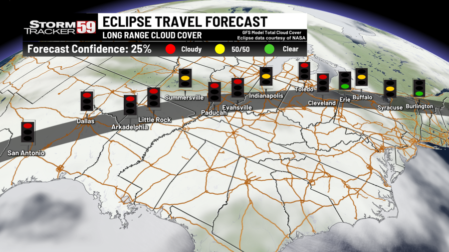
Monday continues the warming trend as a southwest breeze kicks in, with highs returning to the mid 60s. For the eclipse watchers, we will have a warm front scoot north of the region, which could give us a few showers. However, there should be plenty of dry time at this juncture and plenty of breaks in the clouds during the afternoon for those seeking to get a good look here in our region!
Tuesday brings our next system through, as a low pressure system moves up into the Great Lakes. This, in turn will provide the chance for rain showers but it’s a warm day with highs in the upper 60s.
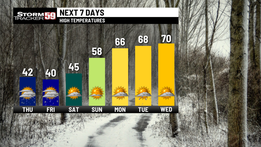
Wednesday continues the chances for a few showers with an unsettled pattern continue as a front approaches. Despite the occasional showers, we should see high temperatures near 70.
Looking ahead, we will see a much warmer pattern develop. Thursday continues the risk for a few showers with highs in the mid 60s. We will dry out on Friday but it’s slightly cooler with highs near 60. Saturday will be mostly sunny with high pressure in control with highs in the mid 60s.

Help us with our growing community of weather photos with #weathertogether. Head to our website and search for the ‘Weather together’ tab and upload your photos of weather going on around our region.

We are in spring forest fire season in West Virginia – this means don’t burn between 7 AM and 5 PM through May 31st. Low humidity values during the daytime, along with breezier and warmer conditions will at times increase the fire threat, hence the burn ban during most of the daytime. Follow all regulations or be faced with potential consequences, such as fines! In Virginia, the spring fire season continues through April 30th – don’t burn before 4 PM.

TONIGHT
Rain and snow showers. Lows near freezing.
THURSDAY
Overcast with a cold rain for most, mountain snow. Highs in the low 40s.
FRIDAY
A mix of rain and snow showers. Cold! Highs around 40.
SATURDAY
Brief AM mountain snow. Clearing west to east. Highs in the mid 40s.
SUNDAY
Mostly sunny. Warmer! Highs in the mid 50s.
MONDAY – ECLIPSE DAY!
Isolated shower or two. Plenty of dry time! Partly cloudy. Highs in the mid 60s.
TUESDAY
Few showers. Highs in the upper 60s.
WEDNESDAY
Shower chances continue in isolated fashion. Highs near 70.
THURSDAY
Few showers. Highs in the mid 60s.
FRIDAY
Partly sunny. Highs in the 50s.
SATURDAY
Mostly sunny. Highs in the 60s.
For the latest news, weather, sports, and streaming video, head to WVNS.

