Sixth Ohio tornado now confirmed. See the paths they took during Wednesday's storms
A sixth tornado has now been confirmed to have touched down during Wednesday morning's storms in Ohio, including four that hit central Ohio counties, leaving damaged homes and vehicles, destroyed garages and splintered and downed trees in their wake.
The latest tornado, which was confirmed Thursday afternoon, passed through Malaga Township in northern Monroe County in eastern Ohio. It was an EF2 tornado on the Enhanced Fujita scale, with estimated peak winds of 120 mph reached in the area of Route 800 and Minder Road, according to the National Weather Service in Pittsburgh, which covers eastern Ohio, western Pennsylvania and the northern panhandle of West Virginia. The timing, path length and path width of the tornado is still being investigated.
Fortunately, no deaths or injuries were reported as a result of the six twisters. But there was some significant damage from the tornadoes.
The Franklin County Emergency Management Agency and Homeland Security said six homes in the county sustained major damage and numerous others have minor damage. No dollar estimates are being compiled because at least 25 homes with major damage are necessary for the county to seek a federal disaster declaration that would provide federal recovery funds.
In Madison County, a historic barn was flattened and a hangar and some small planes at the county airport were destroyed. In eastern Franklin County and western Licking County, a tornado leveled hundreds of trees, damaged homes and ripped the roof off a garage, twisting it around a tree. In Hilliard in northwestern Franklin County, a garage wall was completely blown out by the storm.

The National Weather Service in Wilmington surveyed tornado damage Wednesday and recorded preliminary paths for five of the twisters using the damage assessment tool from the National Oceanic and Atmospheric Administration (NOAA).
Here's a look at the paths of the five tornadoes surveyed by NWS Wilmington and a look at the Malaga Township twister surveyed by NWS Pittsburgh:
EF2 tornado struck Jefferson Township, eastern Franklin County, then decreased to an EF1 in western Licking County
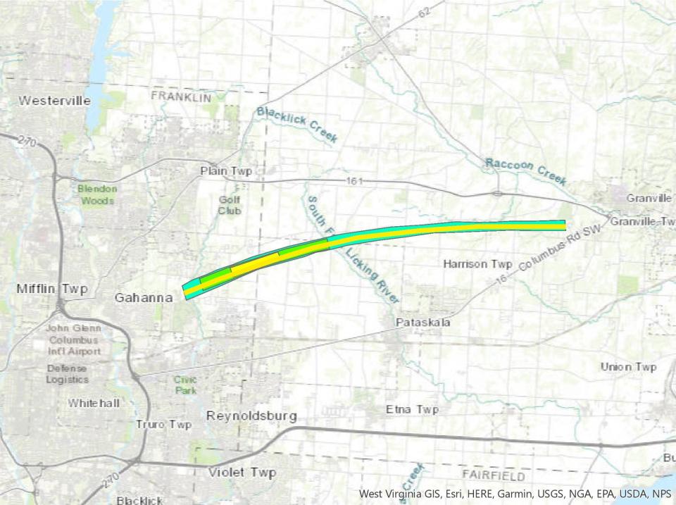
According to the National Weather Service's preliminary report, this EF2 tornado began around 5:49 a.m. near the intersection of Havens Corners Road and Reynoldsburg-New Albany Road In Jefferson Township.
A large tree near the Jefferson Township Volunteer Fire Department station was uprooted and knocked down, a section of a tree fell on a truck and a car in front of a residence along Reynoldsburg-New Albany Road and there was damage to other trees in the area and a fence at the Jefferson County Club. Just east of the fire station on Havens Corners Road, a large tree was downed onto utility wires.
The tornado moved east/northeast, downing trees along Havens Corners Road almost to North Wagonner Road, tearing through the Havenswood neighborhood along Havens Road and tearing up trees with winds of up to 100 miles per hour. At least one tree closed Havens Road south of North Waggoner Road until it could be removed.
The tornado continued to strengthen as it knocked down or uprooted trees along North Waggoner Road and headed east onto McOwen Road, tossing a shipping container and sending debris flying for hundreds of yards with winds up to 120 miles per hour, according to the report.

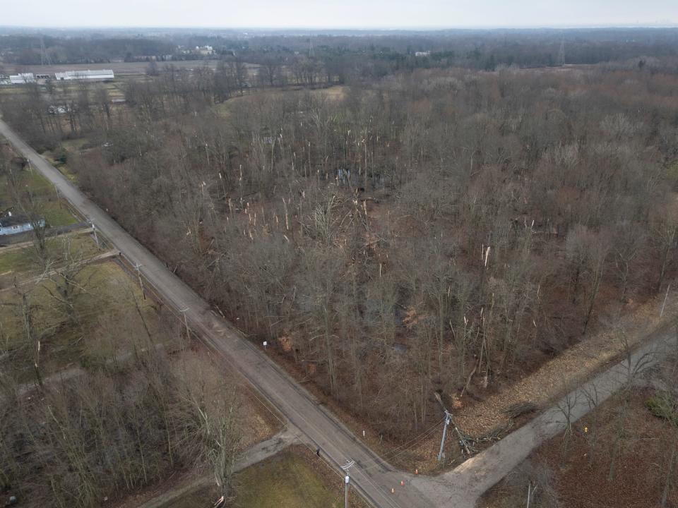
The heaviest damage appeared to occur at the east end of McOwen Road along Dixon Road, which is the border between eastern Franklin County and western Licking County. Hundreds of large trees were downed, uprooted, or twisted and splintered in this area.
Homes and garages in the area were damaged and Dixon Road was closed for several hours as Jefferson Township public service crews helped remove large trees that had fallen across the road.
As the tornado moved further northeast in Pataskala in western Licking County, the NWS said it weakened to an EF1 tornado and passed just north of Licking Heights High School and Middle School. But it still contained enough power to rip the roof of a garage, damaged other roofs, windows and trees in the area of Graham Road Southwest and Mink Street in Pataskala and to some homes in Jersey Township.
The tornado continued to weaken as it moved east across rural farm areas until it dissipated near the southwest side of Granville at around 6:03 a.m., the report said.
In total, the tornado traveled more than 14 miles and was more than 300 yards across at its widest point.
EF1 tornado near West Jefferson in Madison County
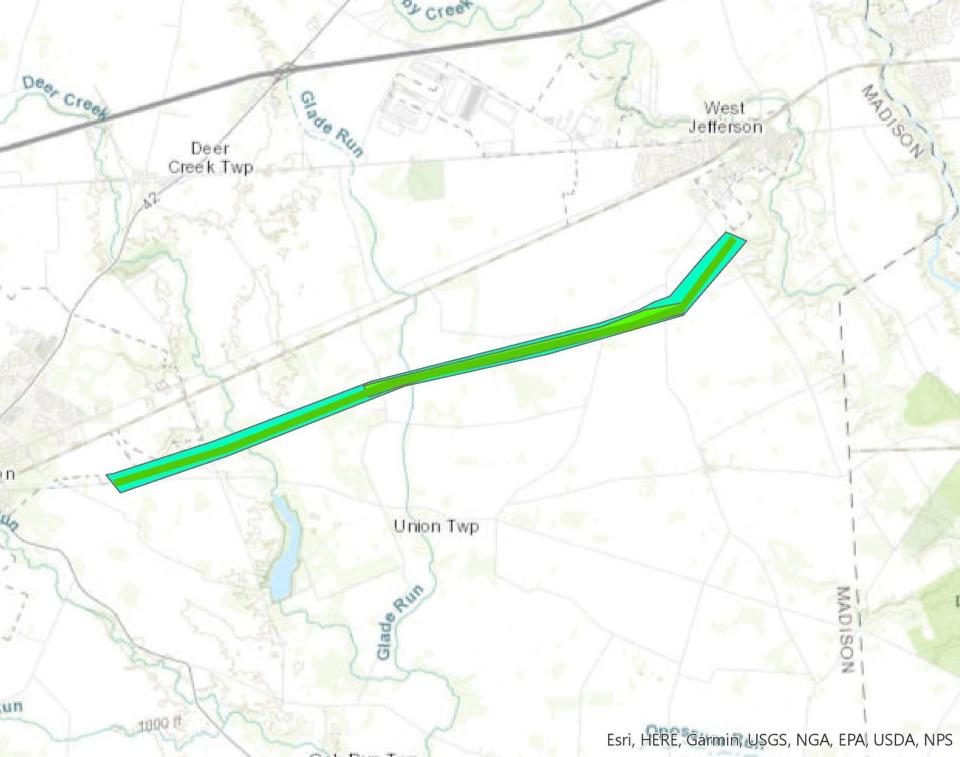
This EF1 twister first appeared near Route 665 east of London at around 5:14 a.m. It began by traveling east-northeast toward Spring Valley Road, picking up strength and causing minor structural damage as it went, according to the report.
It continued to head toward Wilson Road, where its strength peaked with winds up to 110 miles per hour. At its peak strength, the tornado damaged part of a home's roof and snapped trees near their trunks, the report said.

The twister continued across West Jefferson-Klousville Road when it turned to the northeast, weakening as it crossed Olmstead Road and dissipated about 5:23 a.m.
Over its lifespan, the tornado traveled over eight miles and was an estimated 250 yards across at its widest point.
EF2 tornado near Springfield in Clark and Madison County
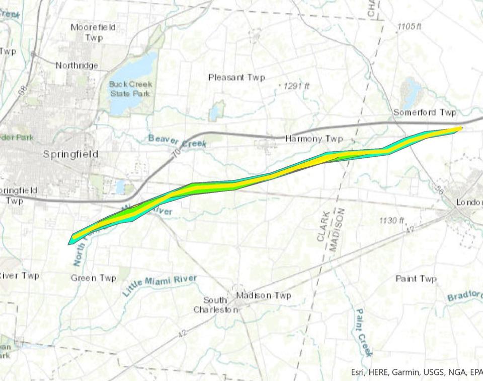
This tornado first formed south of Shawnee High School in Clark County at around 4:52 a.m., according to the NWS report. It moved northeast, growing wider and stronger as it neared Ridge Road, where it caused three homes to lose their roofs, the report said.
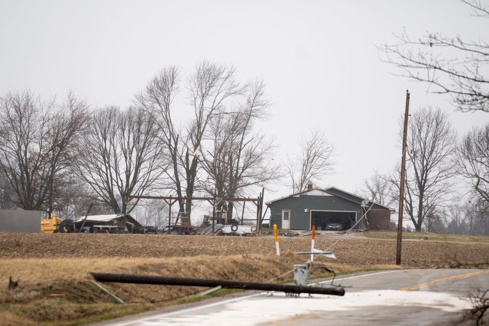
The twister then traveled east-northeast into Madison County, tearing through barns and outbuildings and ripping off roofs. The Ohio State University's Molly Caren Agricultural Center sustained significant damage, with a barn leveled.
The twister struck the Madison County Airport, destroying one hangar, and heavily damaging other hangars and small privately owned aircraft there that were tossed around like toys. A section of U.S. 40 by the airport remained closed into Wednesday night while debris was cleared and removed.

The NWS has not released information on where and when the tornado dissipated because U.S. 40 by the airport and other roads north of London were impassable at the time of their survey.
The EF2 tornado traveled more than 18 miles and was an estimated 500 yards across at its widest point. The NWS said the path of this tornado could be extended once it can send survey crews out north of London to continue its survey, the report said.
EF1 tornado in the Hilliard area in Franklin County
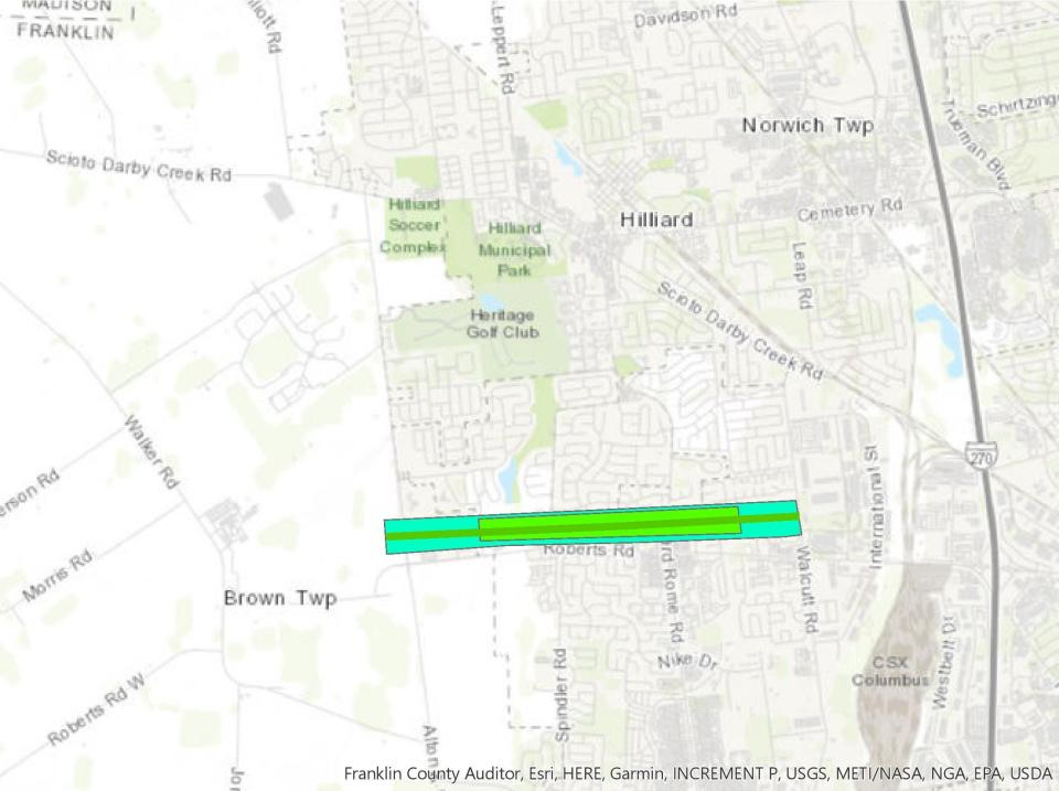
The severe storm front spawned an EF1 tornado that touched down around 5:26 a.m. on the west side of Alton and Darby Creek Road, according to the NWS report.
The twister traveled along the north side of Roberts Road through Hilliard, snapping trees, damaging roofs and sidings, and peeling away a garage on Oldwynne Road with winds of up to 110 miles per hour, the report said.

As the twister approached Interstate 270, it began to weaken before dissipating entirely at 5:29 a.m. on the west side of the interstate.
This short-lived whirlwind traveled more than two miles and was an estimated 250 yards across at its widest point.
EF1 tornado near Riverside in Montgomery and Greene County
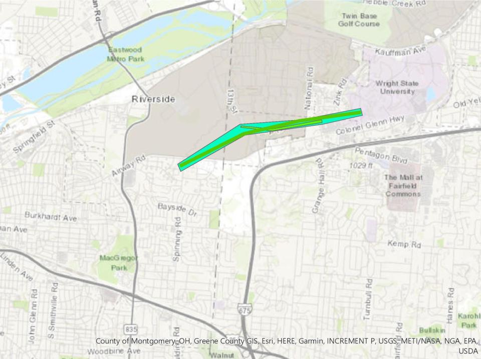
This whirlwind first appeared at around 4:37 a.m. just south of the Wright-Patterson Air Force Base. It damaged a hangar and sent debris flying into planes being stored on the base as its' winds reached 100 miles per hour. It left the base heading eastward, where it ripped shingles from an apartment complex behind a local Meijer's, according to the report.
The tornado broke branches and caused minor tree damage as it moved toward Greene County, the report said. It weakened as it approached Wright State University before dissipating entirely at around 4:41 a.m. just west of WSU's student union.
This tornado traveled just over two miles and was an estimated 200 yards across at its widest point.
EF2 tornado in Malaga Township
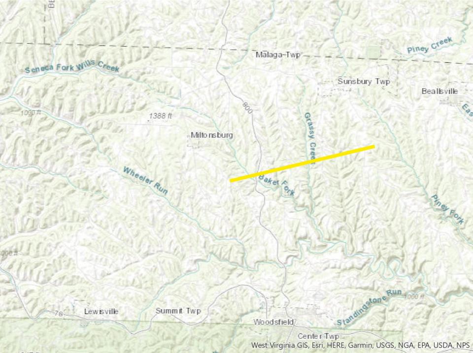
This EF2 tornado touched down west of State Route 800 at 7:22 a.m. It began traveling east toward Minder Road where it shifted a house of its foundation, blew out its windows, and collapsed its garage, according to the report.
It continued on to Grizzel Ridge Road where it destroyed outbuildings and tossed a camper 20 yards. The cyclone kept traveling eastward over Moore Ridge Road and Township Road 2105, ripping roofs off of homes and destroying outbuildings, the report said.
The twister dissipated near the Ozark neighborhood at 7:26 a.m.
@PartofMyHart
NHart@gannett.com
This article originally appeared on The Columbus Dispatch: Six tornadoes hit Ohio yesterday: Here's where they struck

