On & Off rain Wednesday keeps storm threats low ahead of a cold front tonight
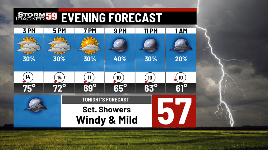
Wednesday will be an on again, off again set up as waves of showers come and go at times. Mostly cloudy skies keep us slightly cooler over Tuesday but southwest winds 10-15mph keep us near the low to mid 70s. This afternoon and few heavier showers are expected with even a rumble of thunder.

A cold front advancing east will slide across the region tonight with a rumble of thunder with a storm or two on the strong side. Our threat of severe weather is lower than the last few days thanks to morning clouds but strong winds and hail will be possible with the strongest of storms. Winds will be elevated area wide 15-20mph with gusts pushing 25-30mph at times tonight. The cold front won’t stick around long with showers and winds fading into the overnight for a nicer Thursday ahead.
Thursday is shaping up to be a beautiful day with high pressure moving in quicker than expected. Morning clouds fade to afternoon sunshine. West-southwest winds 5-10mph help push us back into the mid 70s. We have clouds at times with the extra humidity, but rain is not expected until the overnight hours as another cold front sets to move in for Friday morning.

Friday morning will be a soggy one with steady, widespread showers along a cold front. It’ll take most of the morning to kick the system towards the east so umbrellas to start would be a good call. The afternoon high pressure once again moves back in to help clear us up. Sunshine will return for a humid and mild afternoon. Winds will be elevated but we’ll still mange the upper 60s and low 70s. By the overnight, we’ll clear up as lows drop back into the low to mid 40s for a cooler night.

Saturday will be a interesting day with clouds and sunshine to start. A southern system in Tennessee is close enough for a shower or two but trends have this moving farther south. The farther south this system goes, the less likely showers will be for our region. Our interactive radar can help with your outdoor plans. Highs are much cooler than previously this week as we struggle our way into the the low 60s. Overnight lows dip into the upper 30s with some in the valleys waking up Sunday morning to frost.

Sunday is a cooler day with a mix of sun and clouds. Highs struggle into the mid 50s with breezy conditions most of the day. For those that got an early jump on spring planting, take precautions as rural areas will drop back into the 30s once again for overnight lows. Frost will be the main concern as we stay above the freezing mark. Cold hardy plants (root plants) will be ok but more sensitive plants like tomatoes and flowers my be hurt.
Monday is looking nicer with temps near average and plenty of sunshine as high pressure visits for a short time. Temps push into the upper 50s and low 60s for the afternoon before cooling into the overnight back into frost territory of the mid and upper 30s.

Tuesday a weaker system arrives with a few scattered showers off an on through the day. Some dry time with peeks of sunshine will help keep us in the 60s for highs. Overnight lows are improved with the extra clouds hanging around as we stay in the low 40s overnight.
In your extended forecast we’re still active with a few rainy days followed by short breaks. Temps will rise and fall with each system but stay near seasonal average in the mid and upper 60s. We are rounding the corner of April with May on the horizon but gardeners take note, frost threats continue well into the middle of May. Early plantings may need protection from time to time as lows still flirt with the 30s.

Spring burn bans are still in place for both Virginia and West Virginia. For Virginia, no burning before 4pm is allowed through April 30th while in West Virginia no burning is allow from 7am to 5pm through May 31st. Burning during bans can result in fines, expensive reimbursements to fire departments, and civil lawsuits from damage caused from out of control fires.

WEDNESDAY
Sct. Showers, some heavy, PM storms. Highs in the upper 70s.
THURSDAY
Sunshine & mild. Highs in the low 70s
FRIDAY
Showers and iso. rumbles. Highs in the mid 70s.
SATURDAY
Mostly dry day, low risk of showers PM. Highs in the 60s.
SUNDAY
Drying out, breezy, cooler. Highs in the 50s.
MONDAY
Sunny & breezy. PM sprinkles. Highs in the 60s
TUESDAY
Sun & Clouds, PM Showers. Highs in the 60s.
WEDNESDAY
AM sprinkles then clearing. Highs in the 60s.
THURSDAY
Sunshine & mild. Highs in the 60s.
FRIDAY
Soggy day, periods of heavy rain. Highs in the 60s.
SATURDAY
Cooler and clearing. AM sprinkles. Highs in the 50s.
For the latest news, weather, sports, and streaming video, head to WVNS.

