North-central US to be focal point for damaging storms into the weekend
Severe weather has primarily focused on the southern tier of the United States this week, but damaging thunderstorms will take aim farther north across the northern Plains and Upper Midwest into the weekend.
The severe storms will get a boost in intensity from sweltering heat and humidity building over the nation's midsection.
Into Thursday evening, storms will fire up and may quickly turn feisty across eastern Montana and northeastern Wyoming.
"As the storms initially develop, a tornado or two cannot be completely ruled out," said AccuWeather Meteorologist Ryan Adamson.
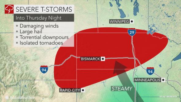
The storms are expected to then congeal during Thursday night as they sweep across much of North Dakota, northwestern South Dakota and northwestern Minnesota, delivering damaging winds, large hail and torrential downpours in the process.
There is the potential for an extensive swath of wind damage with these storms, including downed trees and power lines.
"It is not out of the question that, in the strongest storms, winds could gust as high as 70 to 80 mph," Adamson said.
Motorists along interstates 29 and 94 should be prepared to face dangerous driving conditions in the storms, including near-zero visibility.
The passage of the storms will help to knock temperatures back across the northern tier. Highs in Bismarck, North Dakota, will fall from near 90 degrees Fahrenheit on Thursday to the lower 80s F on Friday and middle 70s on Saturday.
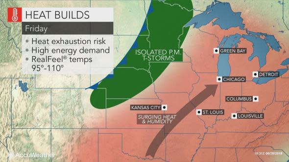
As the push of cooler air slowly sinks southeastward to close out the week, the swath of locally severe storms will follow suit.
Adamson is concerned that most of the storms to end the week will occur after dark on Friday.
The area at risk will include eastern Wyoming, western South Dakota and Nebraska and extend eastward into Minnesota.
The storms can occur near or in the surrounding areas of Rapid City and Aberdeen, South Dakota; Alliance, Nebraska; and St. Cloud and Duluth, Minnesota.
"Torrential downpours, large hail and damaging winds will all be possible with these storms, especially Friday night," Adamson said.
While not every area along this swath will get hit with severe weather or even a thunderstorm, people should be sure to keep their cell phones charged and on with severe alerts enabled prior to heading to bed.
Midwesterners with outdoor activities scheduled to kick off the weekend should be prepared to alter their plans as additional storms are forecast for Saturday.
Storms that erupt on Saturday afternoon and evening could be the most intense of the bunch into this weekend.
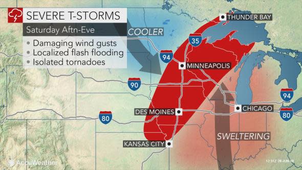
During late Saturday afternoon and evening the storms are likely to focus from the shores of Lake Superior to northeastern Kansas.
