North American monsoon to ease back, reduce flash flood threat into this weekend
The North American monsoon, which has brought localized but dangerous flash flooding to parts of the southwestern United States over the past week, will finally ease back into the upcoming weekend.
A monsoon is a change in wind direction that can trigger long-duration rainfall or dry weather. The monsoon is well known in southeast Asia, but it occurs in other parts of the world as well.
In the case of the southwestern United States, this change in wind direction happens when breezes bring up moist air from Mexico that has originated from the Gulf of Mexico and the tropical Pacific Ocean.
The circulation around an area of high pressure that has been centered over the southern Plains has allowed winds to transport moisture from the Gulf of Mexico into the Southwest.
As a result, some locations have received over 300 percent of their normal July precipitation in the first half of the month alone.
One of these locations is Twentynine Palms, California, where three times the normal July rainfall fell in a single day, with over 1.5 inches falling on July 11.
Palm Springs, California, was also hit by torrential downpours and flash flooding on July 11 when about 1 inch of rain fell in 90 minutes.
In the Phoenix area, between 0.50 and 1.50 inches of rain fell in a few hours on July 9.
On July 15, a massive flash flood struck the Prescott Valley near Flagstaff, Arizona, after as much as 2 inches of rain inundated parts of the area.
Wow... Incredible video of the flash flooding in #Flagstaff today! This is at Leroux and Cottage. Our thanks to Instagrammer @ldubs87 #AZwx #ABC15wx #Monsoon2018 pic.twitter.com/Z9sIbsmsRv
— John Patrick (@JohnPatrickWX) July 16, 2018
Parts of Utah have been hit hard with debris jams and mudslides, as well.
INSANE flash flood with big-time debris plug, massive trees in flow in Johnson Canyon just east of Kanab, UT! First solo flood intercept with @Rankinstudio currently in a different position waiting for another monster flash flood
Monsoon coverage continues for @breakingweather pic.twitter.com/aw9LA69UxY— Reed Timmer (@ReedTimmerAccu) July 17, 2018
NEW: close-range flash flood in Wahweap Wash in southern Utah with debris plug including pine cones from closer to the origin at higher elevation! @Rankinstudio @breakingweather #monsoon pic.twitter.com/OTiq7shn2v
— Reed Timmer (@ReedTimmerAccu) July 16, 2018
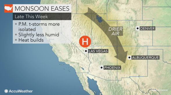
Fortunately, the high pressure that has been over the southern Plains will shift westward and anchor itself over the Four Corners region.
With the high overhead, the moist, southeasterly flow will be cut off as winds subside with sinking air beneath the high.
"Shower and thunderstorm activity will be more localized compared to recent days across the Four Corner states, with the highest elevations having the best chance to see some rain," AccuWeather Meteorologist Brett Rathbun said.
Even though fewer locations will be impacted by daily downpours, Rathbun warned that any slow-moving, heavier downpours can still produce flash flooding.
Storms will be most prominent during the afternoon and evening hours, when sunshine heats up the ground and makes the atmosphere more unstable.
When the moist flow from the Gulf of Mexico becomes cut off, storms generally erupt over the mountains and do not move much since there is no wind to guide them.
"Thus, most valley locations such as Phoenix, Salt Lake City and Albuquerque should miss out on most, if not all of the activity through the end of the week and into the weekend," Rathbun added.
The respite in the monsoon should allow typically dry stream beds, known as arroyos, that were turned into raging torrents over the past few days to recede.
However, in areas that did not receive any rain, the drier times ahead will only exacerbate the severe to extreme drought that is gripping much of the region.
Looking ahead to next week, the monsoon is not forecast to regain the same intensity that it had over the past week.
"By next week, the high should remain strong enough to significantly limit activity across parts of the Southwest, although Colorado and New Mexico could become more active," said Rathbun.
