NOAA predicts very active hurricane season, issues highest-ever May forecast
TAMPA, Fla. (WFLA) – A very active season is in store for the tropical Atlantic, NOAA predicted in its annual forecast for the 2024 hurricane season on Thursday.
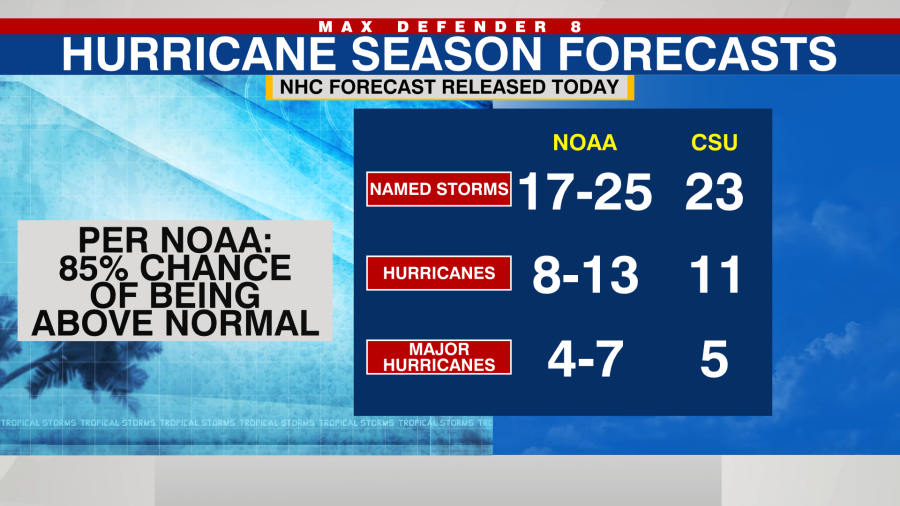
This season has an 85% chance of being above average, according to NOAA. In an average season, there are 14 named storms, seven hurricanes and three major hurricanes. Major hurricanes are those which are rated a Category 3 or higher.
By the numbers, NOAA is forecasting between 17 and 25 named storms, eight to 13 hurricanes and four to seven major hurricanes. It is the highest number of named storms, hurricanes and major hurricanes NOAA has ever issued in its May outlook.
While NOAA can’t say exactly when and where storms will strike, the historic record shows that in very active seasons like we are expecting in 2024, more storms tend to make landfall in the U.S.
NOAA joins other agencies and universities raising alarms for an active season. Colorado State University recently predicted 23 named storms, the European’s (ECMWF) also called for 23 storms and the UK Meteorology Service expects 22.
NOAA’s reasoning for the big forecast is two-fold. Record hot water temperatures in the Tropical Atlantic Ocean and also the demise of El Niño – and likely formation of La Niña by summer.
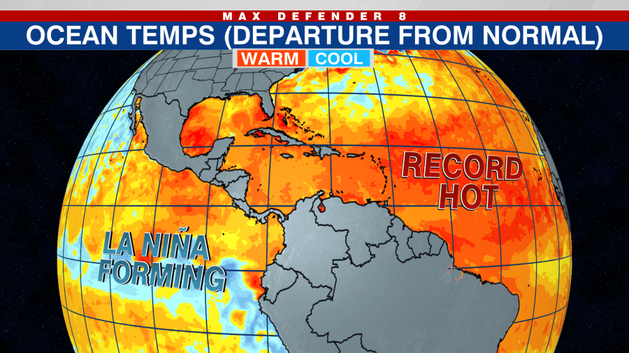
Right now, sea surface temperatures are not only the record hottest overall in the Atlantic, but they are also record-hot in each individual basin, including the central Tropical Atlantic, the Caribbean and the Gulf of Mexico, partly due to global warming.
Hotter oceans will likely result in storms that get stronger. That means we can expect more hurricanes and more major hurricanes than we saw last year. 2023 featured numerous storms, but many were weaker systems.
When was the last time temps reached 90 degrees in NYC?
The second-most important factor in our upcoming hurricane season is the rapid shift away from El Niño in the Pacific.
When El Niño fades and Pacific waters cool, the Atlantic becomes the more favorable basin for storm development. In addition, a fading El Niño means that wind shear across the western side of the Atlantic basin should be below normal. For both of these reasons, it’s shaping up to be a busy hurricane season.
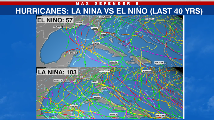
La Niña is also expected to form at some point this summer. The below graphic shows that La Niña years tend to have many more hurricanes than El Niño – almost double – over the last 40 years.
You can also see how during El Niño, which was present during last year’s hurricane season, there are no storms in the western Gulf. But in La Niña, the entire Gulf becomes more active.
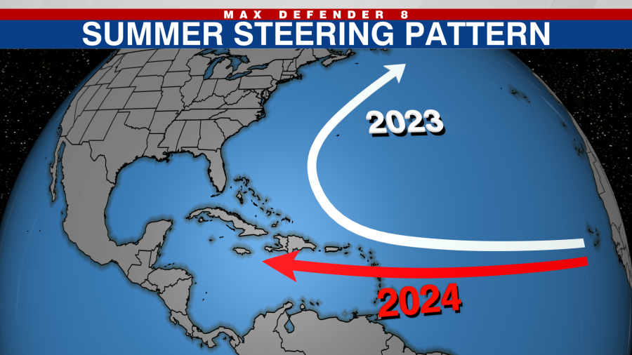
It’s worth mentioning that last hurricane season, the average storm track was near Bermuda, with most storms avoiding landfall in the U.S. That was well forecast by the spring computer models. This year, those same models show a storm track into the Caribbean and also near Florida.
With that said, contrary to the active forecasts for the upcoming season, so far the Atlantic Basin has not seen a named storm. That is rare for the past 20 years, in which we have seen 17 preseason storms form. Unfortunately, a quiet early season does not mean a quiet peak season. They are independent of each other.
Earthquake rattles upstate New York: USGS
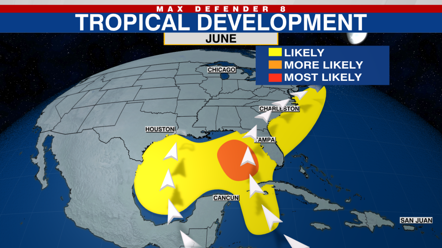
So when will the Atlantic heat up? As a favorable large-scale climate pattern evolves in early June, the Atlantic should wake up, most likely somewhere in the Caribbean or near the Bahamas.
Bottom line: You never know when a where a storm will strike ahead of the season. But with a hyperactive season forecast, it is better to be safe than sorry. Plan and prepare early.
Copyright 2024 Nexstar Media, Inc. All rights reserved. This material may not be published, broadcast, rewritten, or redistributed.
For the latest news, weather, sports, and streaming video, head to PIX11.

