NOAA issues its most aggressive hurricane season forecast on record
NOAA has released its seasonal hurricane outlook for the Atlantic basin, and due to warm waters and a diminishing El Niño, the agency believes the year could be hyperactive.
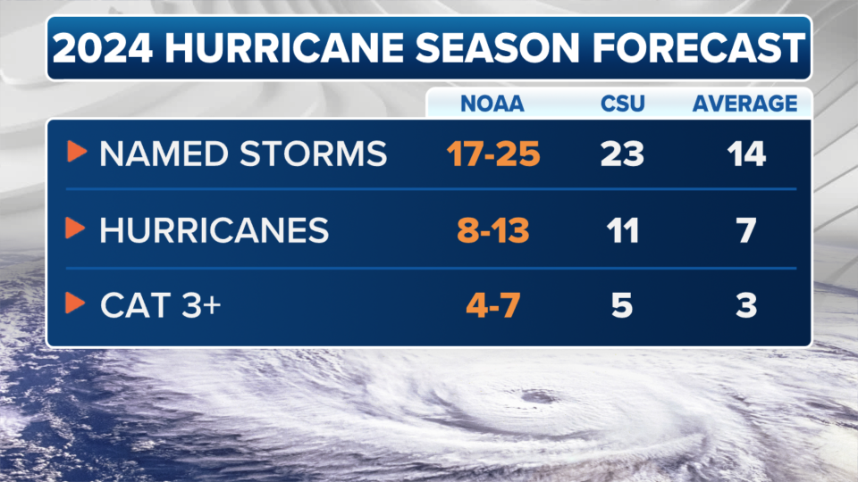
The agency anticipates between 17-25 named storms will form, with 8-13 becoming hurricanes with winds of at least 74 mph. Out of those 8-13, 4 to 7 could become major with winds of at least 115 mph. It's the greatest number of hurricanes predicted by NOAA in its annual May forecast, surpassing the forecast of 14-23 storms in 2010.
Overall, NOAA gives an 85% chance of an above-average season. It would be the eighth season in the last 10 to be above the 1991-2020 average.
Another measurement in NOAA's hurricane forecasting toolkit is Accumulated Cyclone Energy Index (ACE), which measures the combined intensity and duration of all named storms. This year's outlook predicts between 150% to 245% of the median – classifying the prediction as a "hyperactive" season.
The outlook is fairly similar to Colorado State University’s, which also issued its busiest outlook ever, with the potential for upwards of 23 named storms.
"The Atlantic is still record warm in the tropical Atlantic, providing more fuel for storms," Dr. Phil Klotzbach, a senior research scientist at CSU, told FOX Weather before its outlook release.
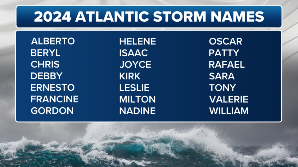
In all, NOAA joins 15 other forecasting agencies and computer models in predicting an above-average hurricane season — and in some cases well above average season. Most are predicting around 20-25 named storms — which would nearly or totally exhaust the list of 21 names for the 2024 season and require using a new supplemental name list.
"These are a lot of big numbers," said FOX Weather Meteorologist Ian Oliver. "None of which are very close to 14, which would be considered the seasonal average."
Both organizations point to the status of the Pacific Ocean’s El Niño-Southern Oscillation, or what is commonly referred to as the ENSO.
Sea surface temperature readings no longer show a strong El Niño to be in control as was the case last season, leading forecasters to believe that tropical cyclone hindrances that accompany these events will not be prevalent in 2024 across the Atlantic basin.
During a typical El Niño, water temperatures tend to be cooler in the Atlantic Ocean and wind shear tends to be more hostile for developing cyclones.
2024 ATLANTIC HURRICANE SEASON GUIDE: HERE’S WHAT TO KNOW ABOUT THIS YEAR’S STORMS
Continued record warm water temperatures across the Atlantic, with a neutral or even a La Niña climate pattern in place are expected to lead to high counts of cyclones.
Neither the NOAA nor the CSU forecasts indicate which U.S. cities might be targets in 2024, but there are some clues as to which region faces either above or below climatological odds of a nearby storm.
The CSU outlook put the odds of a major hurricane making landfall along the U.S. coastline at 62%, while the odds of a strike in the Caribbean were the highest at 66%.
Chances across all coastal U.S. states are about 10-20% higher than what is considered to be average, meaning the country could be in store for more impacts than in 2023.
Last year was considered to be one of the least impactful seasons for the U.S. in nearly a decade, with only one landfalling hurricane in Florida.
But meteorologists stress that no matter whether the hurricane season is predicted to be busy or quiet, being prepared is imperative.
"If you live on the coast, you have to be prepared to be impacted by a hurricane, and it only takes one," said FOX Weather Meteorologist Britta Merwin. "It doesn’t matter if it’s an overperforming year, or an underperforming year. If you get impacted, it will be the worst hurricane season you have been through."
Hurricane season begins June 1, with the first named system in the Atlantic basin typically forming around June 20. Meteorologists are usually tracking the first hurricane by Aug. 11.
This year’s list includes names such as Alberto, Beryl and Chris, with Francine and Milton added in recent years to make up the 21 names.
In addition to the two new names, the NHC says to expect more Spanish-language products and an enhanced forecast cone to be released later in the season.
The experimental forecast cone will show all related watches and warnings from local National Weather Service offices and the hurricane center.
The maps will undoubtedly be more colorful, but forecasters hope the enhanced display of alerts will help the public focus on the wide-reaching impacts of a cyclone and not the center line of the track.
"You know, we’ve been dealing with this track and focusing on where the center of the circulation might go for decades, and it’s going to be a hard habit to break," NHC Deputy Director Jamie Rhome told FOX Weather.
Original article source: NOAA issues its most aggressive hurricane season forecast on record

