Roller coaster week on tap as next storm to bring ice followed by rapid warmup, urban flood risk in Northeast
A brief surge of warmer air at midweek will be accompanied by a storm that brings drenching rain and the risk of urban flooding, but also areas of ice on the front end.
The warmup and storm will follow a painful blast of Arctic air that started the week.
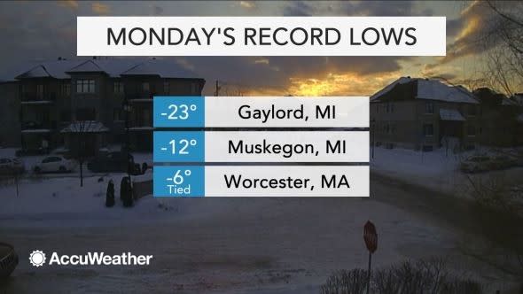
Monday was bitterly cold across the northeastern United States with AccuWeather RealFeel® Temperatures well below 0 F, including in Boston and Pittsburgh. Several spots experienced a record-shattering chill.
Temperatures may be 50 degrees higher in some areas later Wednesday to Thursday.
Arctic air is forecast to retreat rather quickly at midlevels of the atmosphere during Tuesday night and Wednesday. However, near the ground, frigid conditions into Tuesday night, as well as snow and ice cover in many areas, will allow some surfaces to remain cold into part of Wednesday.
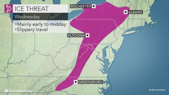
Travel may be affected and some schools may be delayed on Wednesday, due to localized icy and foggy conditions.
The first few hours of the storm are likely to bring rain that freezes on contact with cold surfaces across the interior mid-Atlantic and in parts of New England.
Areas of black ice are possible from parts of northwestern North Carolina and western Virginia, northeastward to northeastern West Virginia, western and central Maryland, central and eastern Pennsylvania, New York state and central and northern New England at some point from Wednesday morning to Wednesday evening.
The fog may form as warm, moist air blows over the cold ground and snow cover.
Warm air is likely to win the battle as the day progresses on Wednesday. Temperatures are forecast to climb into the 30s and 40s F across the interior Northeast and into the 40s and 50s along the coast. A few spots in eastern Virginia and southeastern Maryland may approach 60.
Fast forward motion of the storm is likely to limit the duration of the rain, which will vary in intensity, to 24 to 36 hours in most cases.
A general 0.50 to 1 inch of rain is likely with local amounts to 2 inches.
The rain can still be heavy enough in the absence of snow cover to cause flooding in urban and poor drainage areas in the Southeast and coastal mid-Atlantic states.

In the central Appalachians, since the snow may be more prone to rapidly melt, there is the risk of flash flooding. However, since there will not be as much snow on the ground over so wide an area as in January 1996, a repeat of the magnitude of the flooding that occurred during the middle of that month is not anticipated.
Where there are piles of snow on the ground or where ice and snow are blocking storm drains, some urban flooding is likely.
Even in areas where temperatures climb above 32 F and plain rain falls, the ground can remain cold enough from the latest arctic blast for the rain to freeze on contact with the surface, causing icy patches on roads and sidewalks.
The rain and warmup will provide an opportunity to remove some the snow and ice ruts there were left behind following the storm and freeze-up.
The rain will add weight to the snow on the roofs from parts of northern Pennsylvania to New England. The risk of roof collapses will be greatest on flat roofs.
There is a chance that just enough cold air catches up with the last part of the storm to allow rain to change to snow from the western slopes of the Appalachians to western and northern New England on Thursday.
Should the cold air come in quickly enough, there may be a few inches of snow in parts of the I-81 corridor of Pennsylvania and I-88 of New York state.
"Temperatures on Thursday are likely to dip back to seasonable levels, but another big blast of Arctic air will arrive on Friday in the Northeast," according to AccuWeather Lead Long-Range Meteorologist Max Vido.
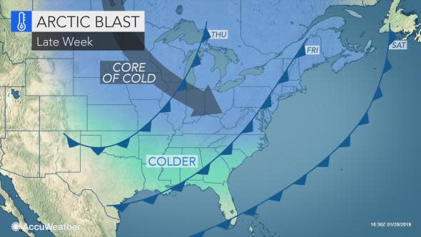
The air may be every bit as cold as that of Monday and Tuesday.
"While the cold shot and warmup will be brief during the first part of this week, we expect longer-duration cold blasts and less pronounced warmups during the latter part of January and into the first part of February," Vido said.
The pattern may not only offer more opportunities for snow over the interior Northeast, but also in many coastal areas.
Download the free AccuWeather app to see the timing and nature of the next storm for your area.
Join host Regina Miller as she examines Forensic Meteorology and the reconstruction of weather events for legal testimonies. Steve Wistar, AccuWeather's Forensic Meteorologist and Certified Consulting Meteorologist recalls prominent legal cases where winter weather played a key role in the verdicts.

TradeWx offers protection against financial risks of snow accumulation and other weather events. Learn more on TradeWx.com.

