National Weather Service tornado surveys
UPDATE: This story has been updated to include information about a tornado in St. Joseph/Cass County.
LANSING, Mich. (WLNS) –The National Weather Service has confirmed four tornadoes in Michigan from the storms that rolled through the state on May 7th, 2024. There was a confirmed EF1 tornado in Branch County and another EF1 in Cass County. Two EF2 Tornados occurred, one in Kalamazoo County and another in St. Joseph/Cass County.
Cass County Tornado
The first of these storms touched down north of the Municipal Airport in Dowagiac at 5:11 pm. The storm damaged trees and snapped several power poles as it traveled northeast near Twin Lakes, where it reached its maximum width of 950 yards. In the Twin Lakes area, hundreds of trees of different sizes were snapped and uprooted on all sides of the lake. The tornado continued to travel northeast and dissipated near the Cass/Van Buren County line at 5:38.

Kalamazoo County Tornado
The second tornado touched down at 5:55 pm near Portage, Michigan, and traveled northeast for 11 miles, lifting around 6:17.
At its peak, the storm had an estimated wind of 135 miles per hour, making it a strong EF2 and just 1 mile per hour below the criteria for an EF3, and was approximately 300 yards wide.

As the storm traveled through Kalamazoo County, it damaged multiple communities, with many homes experiencing roof and siding damage. Two mobile home parks in that area experienced damage, with several homes destroyed. In addition, multiple businesses within its path saw significant damage, including a FedEx warehouse near the Kalamazoo/Battle Creek International Airport.
Several eyewitnesses reported a second tornado on the ground in the Portage area around 7:19 pm, sparking another tornado warning. However, the National Weather Service has not confirmed a second tornado for this area.
Branch County Tornado
The tornado in Branch County briefly touched down in Union City at 6:07 pm. The storm traveled 1.09 miles, with the only damage reported to a machine shed and its anchor posts.
The National Weather Service is still conducting its damage survey of a stronger tornado near Centerville, the tornado that prompted the state’s first “Tornado Emergency”. The track and rating of the storm have yet to be released, but we will provide additional updates as those details become available.

Thankfully, after the very active night of severe weather across the southwestern portion of the state, the National Weather Service is not reporting any fatalities from any of the tornadoes at this time.
St. Joseph/Cass County Tornado
At 5:41 pm, a tornado touched down in St. Joseph County near Centerville, Michigan. The storm traveled northeast for almost 20 miles, eventually crossing into northern Branch County near Havens and Goodrich Lake.
The storm peaked at 950 yards wide and had an estimated peak wind of 130 miles per hour, making it an EF2 tornado. There was extensive damage to trees and irrigation systems almost the storm’s track. But the most significant damage occurred north of Colon and north of Sherwood, where several homes lost roofs and exterior walls.
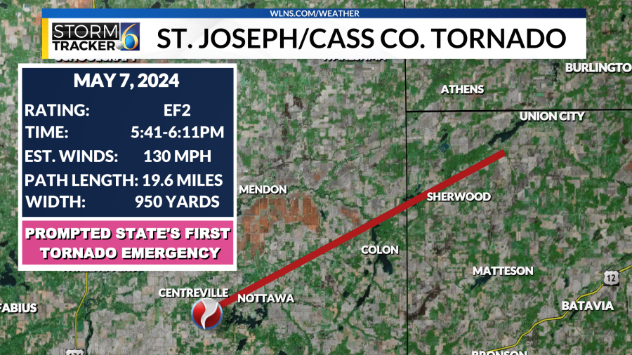
Due to the storm’s intensity, the National Weather Service issued the state’s first-ever Tornado Emergency around 6:10 pm.
The storm weakened and lifted south of Union Lake at 6:11 pm.
In the survey issued by the National Weather Service, they cited video footage and layout of damaged trees that confirmed that this “was a multi-vortex tornado during its peak intensity”.
For the latest news, weather, sports, and streaming video, head to WLNS 6 News.

