National Hurricane Center outlook gives latest on what's happening in tropics as season nears
The National Hurricane Center's third tropical outlook for the 2024 Atlantic hurricane season is out and the news remains good.
No tropical cyclone activity is expected over the next seven days.
The 2024 Atlantic hurricane season is expected to be very active, and forecasters are urging residents to prepare now, not when a storm is approaching.
To help residents get ready, Gov. Ron DeSantis signed into law the 2024 disaster preparedness sales tax holiday. Save money by purchasing needed hurricane supplies during the two, two-week periods: June 1-June 14 and Aug. 24-Sept. 6.
Here's the latest update from the NHC as of 8 a.m. May 17:
What is out there and how likely are they to strengthen?
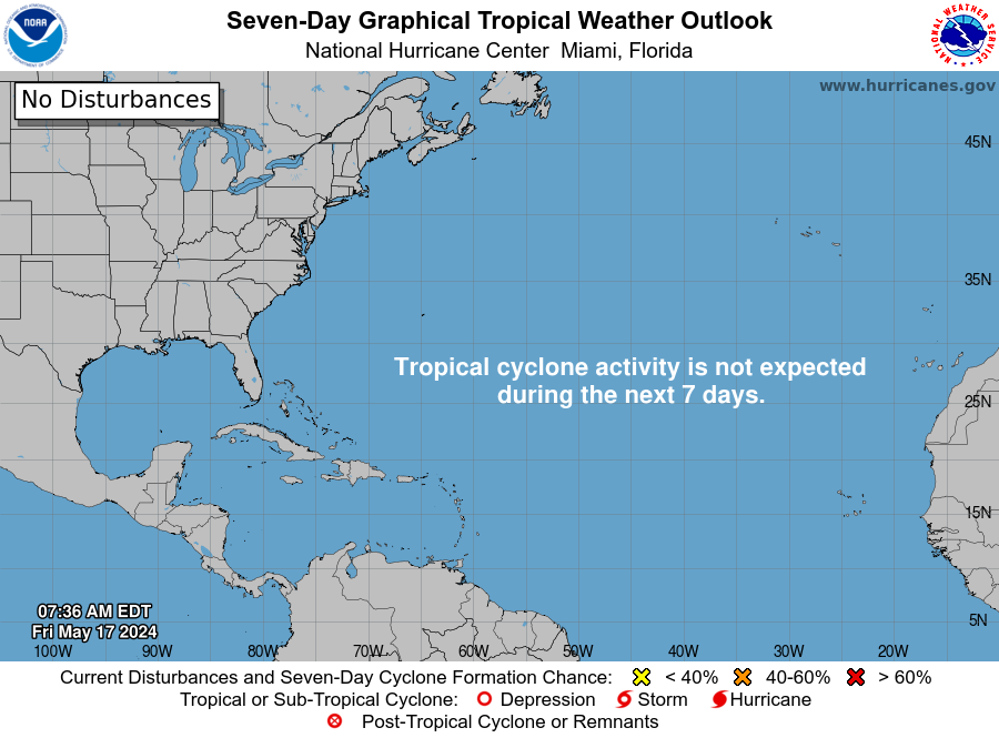
Forecasters with the National Hurricane Center didn't highlight any tropical cyclones or tropical waves in Friday morning's outlook. Here is what they included in the May 17 weather outlook:
A cold front extends from Southwest Louisiana to southern Texas, and a warm front extends from offshore Venice to Southeast Louisiana. A large area of heavy showers and strong thunderstorms is moving east across the Gulf across coastal areas of Mississippi to the Florida Panhandle.
Strong southeast winds and seas of 4 to 7 feet are indicated in satellite data in the south-central Gulf.
"Active weather" can be expected along the northern Gulf as the warm front moves north and inland through late today. A stationary front across Texas coastal waters will meander today before shifting east across the northern Gulf tonight through Monday, supported by a series of upper-level disturbances moving from west to east.
A system extending to the central Bahamas is bringing strong winds out of the southeast, along with seas of 5 to 8 feet.
Seas of 4 to 7 feet are reported in the south-central Caribbean.
Smoke from agricultural fires in Central America is moving into the northwestern Caribbean.
A cold front far east of Florida extends southwest to the northwestern Bahamas. Scattered showers and isolated thunderstorms are associated with the system.
A new front is forecast to sink southward into the waters offshore of Georgia and Northeast Florida early Monday and move southeast and weaken through Tuesday,
Who is likely to be impacted?
Forecasters urge all residents to continue monitoring the tropics and to always be prepared.
That advice is particularly important for what is expected to be a very active hurricane season.
Weather watches and warnings issued in Florida
When is the Atlantic hurricane season?
The Atlantic hurricane season runs from June 1 through Nov. 30.
When is the peak of hurricane season?
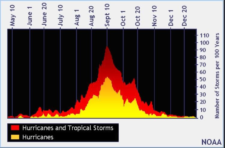
The peak of the season is Sept. 10, with the most activity happening between mid-August and mid-October, according to the Hurricane Center.
National Hurricane Center map: What are forecasters watching now?
Systems currently being monitored by the National Hurricane Center include:

Noaa
Embedded content: https://www.nhc.noaa.gov/xgtwo/two_atl_0d0.png?052051
Excessive rainfall forecast
What's next?
We will continue to update our tropical weather coverage daily. Download your local site's app to ensure you're always connected to the news. And look for our special subscription offers here.
This article originally appeared on Treasure Coast Newspapers: NHC forecasts no tropical cyclones next week ahead of hurricane season

