Nashville area could see severe thunderstorms Thursday night. What to expect
The National Weather Service is warning of a line of severe thunderstorms for the Middle Tennessee area beginning Thursday night and headed into Friday morning.
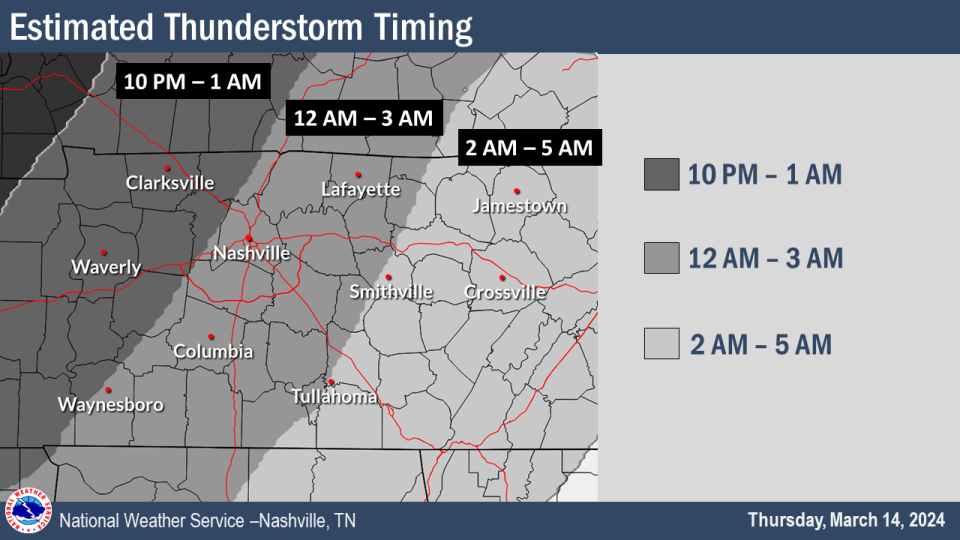
Severe storms will push into western areas after 10 p.m. and will continue to work east overnight into Friday at 7 a.m., the weather service stated in a news release.
All of Middle Tennessee could see strong storms however the greatest threat for strong to severe storms will be along and west of Interstate 65, they said. Heavy rain is likely with thunderstorms.
Severe Weather Outlook for TONIGHT ⚠️
Confidence continues to increase in at least some portions of Middle TN seeing strong to severe thunderstorms overnight tonight. Damaging straight line winds are the main threat but large hail and a tornado can't be ruled out. pic.twitter.com/0Ft78Ti5Ve— NWS Nashville (@NWSNashville) March 14, 2024
"A 5% hail threat and 2% tornado threat only include areas west of I-65," said the weather service, although the chances can't be ruled out. "There will be some lingering rain chances on Friday, especially along the Cumberland Plateau and southern portions of Middle Tennessee.
Storms have the potential of producing damaging winds causing tree damage and power outages, said the weather service. Since the severe weather will occur overnight, the weather service recommends charging cell phones and having wireless, emergency alerts enabled, keeping a flashlight and appropriate shoes nearby and having a safe place prepared.
Nashville-area 7-day forecast
Thursday: Mostly sunny, with a high near 81.
A low around 62 at night with a chance of showers and thunderstorms likely after 2 a.m. Chance of precipitation is 70%. New rainfall amounts between a quarter and half of an inch possible.
Friday: Mostly cloudy, with a high near 70. Showers likely and possibly a thunderstorm before 2 p.m., then a chance of showers and thunderstorms, mainly between 2 p.m. and 5 p.m. Chance of precipitation is 70%. New rainfall amounts between a tenth and quarter of an inch, except higher amounts possible in thunderstorms.
Mostly cloudy, with a low around 46 at night. A 10 percent chance of showers and thunderstorms before 7pm.
Saturday: Mostly sunny, with a high near 67. Partly cloudy, with a low around 47 at night.
Sunday: Partly sunny, with a high near 63. Partly cloudy, with a low around 36 at night.
Monday: Sunny, with a high near 51. Mostly clear, with a low around 29 at night. Widespread frost after 4 a.m.
Tuesday: Sunny, with a high near 55. A widespread frost is predicted. A low around 36 at night.
Wednesday: Mostly sunny, with a high near 61.
Nashville-area weather radar
Diana Leyva covers trending news and service for The Tennessean. Contact her at Dleyva@gannett.com or follow her on X, the platform formerly known as Twitter at @_leyvadiana
This article originally appeared on Nashville Tennessean: Nashville weather: Severe storms expected in Middle Tennessee

