Swipe to see how a major drought is devastating California's water resources
Amid a major drought affecting much of the western United States, NASA released a series of unsettling satellite images Thursday reflecting the devastating effects of the dry conditions on California's mountain snowpacks and two largest reservoirs.
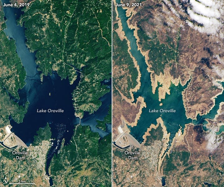
Images captured by the Operational Land Imager on the Landsat 8 satellite show Shasta Lake and Lake Oroville this year and in June 2019 during more typical conditions. The 2021 images reveal tan fringes around the waterlines of the lakes – areas of the lakebed that are underwater when the reservoirs are filled closer to capacity, according to NASA.
Shasta Lake, the largest reservoir and third-largest water body in California, saw its lake level drop 106 feet in elevation in the time between when the two images were taken, NASA said.
Lake Oroville, the state’s second-largest reservoir, saw its water level fall 190 feet.
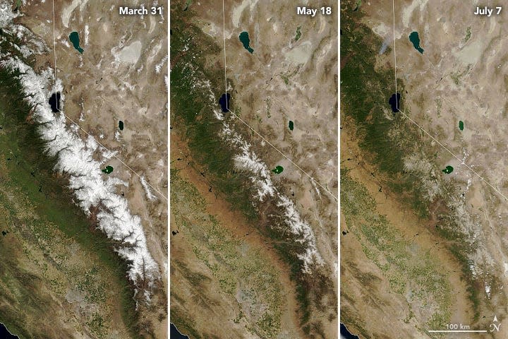
More images captured by the Moderate Resolution Imaging Spectroradiometer on NASA's Terra satellite document the earlier-than-usual snow melt this year in the Sierra Nevada. The snowpack accounts for nearly a third of California’s water supply in a given year, according to NASA.
The satellite images show snow progressively vanishing from the Sierra Nevada on March 31, May 18 and July 7.
West's drought has no end in sight: 'If we do nothing, it’s going to be really bad'
In Oregon, a blaze may burn until fall: As Western wildfires rage, region to remain 'tragically dry' for at least a week
"Gulp, the Sierra snowbank — a key source of water in the U.S. West — is short on funds," the NASA Earth Observatory tweeted Thursday. "Mountain snow melted away nearly a month ahead of schedule, leaving reservoirs without their usual inflow of freshwater."
The satellite images come as 89% of the western U.S. is in a drought, according to the U.S. Drought Monitor. The region is exiting an unusually wet time in its history and heading straight into a "megadrought" – an unusually dry time that could last years, decades or centuries, a study in the journal Science found last year.
Scientists say that about half of the historic drought can be blamed on human-caused climate change. Since temperatures are projected to keep rising, it is likely the drought will continue for the near future – or fade briefly only to return, researchers say.
Jay Lund, co-director of the Center for Watershed Sciences at the University of California, Davis, said California hasn't seen a year as dry as this one since the 1976-77 drought.
"I think we’re going to see some substantial economic loss for agriculture in parts of the state," Lund said. "The major concern for drought management this year is to make sure we’re well-prepared in case next year is also dry."
The low levels of precipitation and above-average temperatures across the western U.S. are also increasing the risk of more frequent and more destructive wildfires. Friday, more than 17,000 wildland firefighters and support personnel were assigned to wildfires, the National Interagency Fire Center said.
"The wildfires that we’ve had associated with droughts, made worse by drought, have been bringing damages far greater than what we’ve seen with previous droughts," Lund said.
Last week, California Gov. Gavin Newsom asked people and businesses to voluntarily cut how much water they use by 15%. He also added nine counties to an emergency drought proclamation that now covers 50 of the state's 58 counties.
Contributing: Doyle Rice, USA TODAY
'Worst is yet to come': Disastrous future ahead for millions worldwide due to climate change, report warns
This article originally appeared on USA TODAY: California drought conditions: NASA images show low water levels

