Mysterious Holes on The Ocean Floor Have a New Explanation
Off the coast of Big Sur, California, deep beneath the waves, lies a mysterious landscape dotted by large holes in the clay, silt, and sand.
Decades after its discovery, scientists at the Monterey Bay Aquarium Research Institute (MBARI) and Stanford University think they have figured out what is forming the field's curious pattern of circles.
The commonly accepted theory is that pockmarks on the ocean floor are the product of methane gas or even hot fluids, flowing upwards out of Earth's interior and blowing some fine sediment away. But while that might be true of underwater hollows in some parts of the world, that is not always the case.
Exceptions to the rule are mounting.
The Sur Pockmark Field off the coast of California is the largest of its kind in North America. It is about the size of Los Angeles and contains more than 5,200 hollows, the average of which stretches as far as 175 meters (574 feet) wide and 5 meters (16 feet) deep.
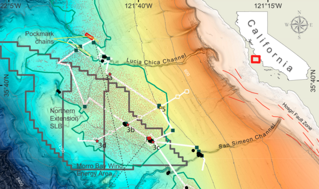
The site is slated for a potential offshore wind farm, but there have been concerns the presence of methane could undermine infrastructure stability.
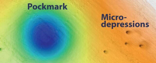
On a recent expedition to the Sur pockmarks, which are located at a depth of 500 to 1,500 meters, an underwater robot, operated by MBARI researchers, found "scant evidence" of methane vents or other fluid flows. Instead, the team thinks the pockmarks probably formed from sheer gravity.
The large impressions are located on a continental slope, and seafloor samples collected by the robot suggest that sediment has flowed down this slope intermittently for at least the last 280,000 years. The last big flow occurred 14,000 years ago, possibly from an earthquake or slope collapse.
Researchers at MBARI argue that such events could lead to erosion in the center of each pockmark. When a big enough bout of sediment rolls down, it may even cause "sufficient erosion" to chisel out a wider pockmark, shifting the edges of "multiple pockmarks tens of kilometers apart", the team proposes.
This may be what causes the pockmarks to appear in 'chains', although future modeling is needed to confirm that idea.
"We collected a massive amount of data, allowing us to make a surprising link between pockmarks and sediment gravity flows," says research technician Eve Lundsten at MBARI.
"We were unable to determine exactly how these pockmarks were initially formed, but with MBARI's advanced underwater technology, we've gained new insight into how and why these features have persisted on the seafloor for hundreds of thousands of years."
The Sur Pockmark Field is said to be one of the most well-studied seafloors on the west coast of North America. But that's not saying much. Researchers still don't know how sediment or fluid moves across the field.
Until recently, experts didn't know it was porpoises and eels that were creating the smallest holes seen in a similar pockmark field in the North Sea.
The seafloor is sometimes said to be Earth's final frontier. The race is on to scan this alien world, not only for scientific curiosity but also for the viability of new industries, such as offshore wind farming or seafloor mining. But it's one thing to observe an ecosystem and quite another to understand it.
"Expanding renewable energy is critical to achieving the dramatic cuts in carbon dioxide emissions needed to prevent further irreversible climate change," says MBARI President and CEO Chris Scholin.
"However, there are still many unanswered questions about the possible environmental impacts of offshore wind energy development. This research is one of many ways that MBARI researchers are answering fundamental questions about our ocean to help inform decisions about how we use marine resources."
The study was published in the Journal of Geophysical Research Earth Surface.

