Deadly severe weather outbreak slams New Orleans with flash flooding, tornadoes across South
NEW ORLEANS – A Flash Flood Emergency was issued for the city of New Orleans as part of a deadly severe weather outbreak that dropped torrential rains across the lower Mississippi Valley and Gulf Coast and even spawned a few damaging tornadoes.
At least two people died in the storms in Mississippi, while dozens were left injured in various events across the Gulf Coast.
Widespread flooding swamped the New Orleans metro area Wednesday afternoon as several inches of rain drenched the city in just hours, sometimes falling at a rate of 1-3 inches per hour. The 6.24 inches that fell at New Orleans Int'l Airport was the third-wettest April day in their records and accumulated in just seven hours.
Emergency management reported numerous roads and underpasses in and around New Orleans were underwater and impassible from the late morning into the afternoon.
Dramatic videos showed first responders working to block off flooded roads to prevent vehicles from driving on them and getting submerged.
"It is very difficult to maneuver around New Orleans this afternoon," said FOX Weather's Robert Ray as he drove along flooded streets in the city.
In addition to the torrential rains, damaging wind gusts blew through the city. The National Weather Service in New Orleans has reported thunderstorm wind gusts of up to 71 mph at a fire station just east of the city and a gust of 78 mph on the Lake Ponchatrain Causeway. A tree fell onto a home in Pearl River, Louisiana.
Some areas in southern Louisiana managed to record up to 10 inches of rain for the day, including LaPlace.
Just to the north of town in Slidell, crews were picking up debris Wednesday after a tornado swept through a neighborhood.
Slidell police captured video of the aftermath of the severe storm, showcasing damaged storefronts and vehicles, scattered storm debris and fallen power lines along U.S. Route 11. The officer providing commentary in the video below describes the damage to one building as "catastrophic."
"Basically, every apartment was full at the time," one first responder said in the video. "I guess at least 50 people were in there. People’s doors were shut because the railings came in. The whole roof came out. So, we had to get women and children out."
There were several minor injuries to the 50 or so inside the apartment building, including one who was hospitalized for a head wound after being struck by a partial wall collapse, but no serious injuries.
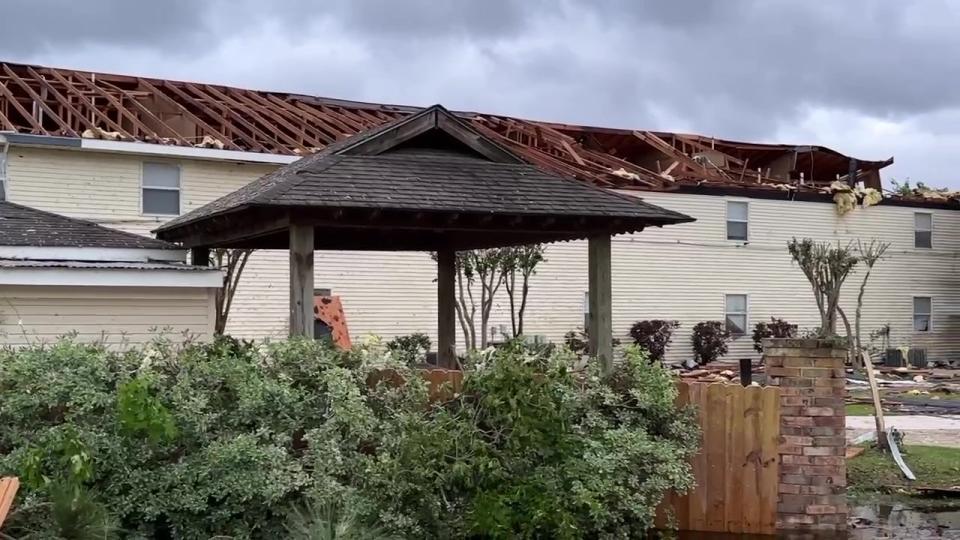
Local government officials said hundreds of homes and businesses in the immediate region received some sort of damage, with over 100,000 electrical outages.
The National Weather Service in New Orleans says their survey team had damage consistent with at least an EF-2 tornado.
To the west of New Orleans, St. Landry Parish emergency managers reported four people were injured when a tree fell on a car. One injury was reported as critical and the victim was being flown to a hospital in Baton Rouge.
Meanwhile, in Mississippi, two people were killed and least six others were hurt in storm-related incidents across the state, emergency managers updated Thursday afternoon. One death in Leflore County was from a storm-related car crash. No details about the other death were given other than it was in Scott County.
At least 179 homes have suffered storm damage across several counties, emergency officials said.
The National Weather Service says 45 of those homes were damaged in Scott County by a miles-long line of strong winds that marched across the state. A storm survey team measured a 13-14 mile-long swath of winds estimated at 80-100 mph. Five people were injured across the damaged area.
Emergency officials are were closely monitoring a potential levee break near a subdivision on Highway 16 in Yazoo County, Mississippi but later determined the levee was stable.
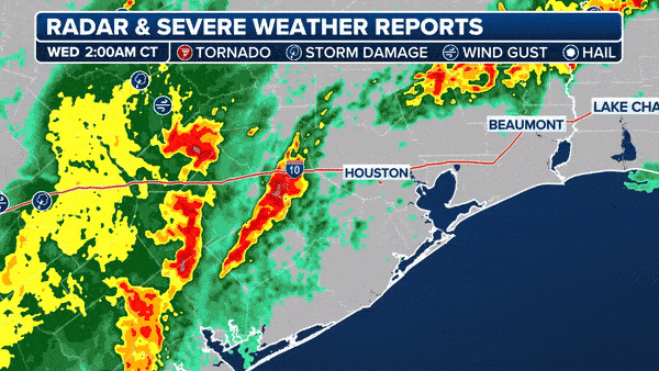
FLASH FLOOD EMERGENCY ISSUED IN TEXAS AS LIFE-THREATENING FLOODING SWAMPS SOUTH
On Wednesday morning, tornado damage was reported in southeastern Texas.
Preliminary estimates suggest the damage in Katy, Texas, was caused by an EF-1 tornado with a brief track and estimated maximum winds of 90 mph, according to a storm survey conducted by the NWS.
"If it was a tornado, it dropped down right in the middle of this parking lot of this strip center and went away," FOX 26 Houston Reporter Shelby Rose said. "I mean, there is no damage anywhere surrounding us. Not even to some small trees."
The NWS in Houston said the tornado lasted just 1 2/3 miles but destroyed a Firestone tire store when the tornadic winds blew out west-facing windows in the lobby. Survey teams said the building's air conditioning unit was launched from the south to the north across the parking lot, while the debris field from the collapsed building was strewn more in an east-west direction.
While there were no people inside that building at the time, there were people inside a sports bar that also received damage.
Luckily, the tornado quickly weakened as it exited the strip mall to EF-0 status, still lasting another 1.5 miles but only leaving some tree limbs broken and minor property damage.
Another tornado touched down in Chunchula, Alabama, damaging a home.
The NWS confirmed that the tornado had a relatively short-lived EF-1 impact and max winds of around 100 mph.
Another Flash Flood Emergency was posted Wednesday morning in Kirbyille and Newton in southeastern Texas, where over 8 inches of rain fell in just 24 hours.
Due to flooding, all major roads into Kirbyville, Texas, were closed Wednesday morning. Multiple fire departments deployed from around the region are conducting rescue efforts in the area.
A dramatic video recorded by the Roganville Volunteer Fire Department in Jasper County, Texas, showed the cab of the fire truck filled with water after the first responders said they rescued a man from a submerged vehicle.
FLASH FLOOD EMERGENCY ISSUED IN TEXAS AS LIFE-THREATENING FLOODING SWAMPS SOUTH
"We just did a water rescue," the firefighter said in the video. "You can barely see the taillights of the car that we picked this young man out of. Needless to say, he was a little bit shaken up."
The firefighter then pans the video and shows how high the water was at the time, which was covering the tailpipe of the truck.
"Sad to say, but we're stuck in the ditch," the firefighter said in the video. "We're waiting on a front-end loader to push us out so we can continue doing our water rescues."
While the firefighters are waiting for help to get pushed out of the ditch, the firefighter keeps rolling as he gets back into the truck, and the water is seen to be so high that its up to their laps.
Analysis from the FOX Weather Center indicates the severe weather outbreak could be classified as a serial derecho.
For meteorologists to classify a windstorm as a derecho – from the Spanish word for "straight" – the swath of straight-line wind damage it causes must cover a distance of at least 400 miles and include wind gusts over 58 mph along most of its path, as well as several, well-separated 75-mph or higher gusts, according to NOAA's Storm Prediction Center.
The storms Wednesday spawned damaging wind reports for over 650 miles, spanning from near Houston to the Florida Panhandle.
The storm eventually passed off to the east Thursday night, drenching the rest of the Gulf Coast and leading to new Flash Flood Emergencies as the storm reached Tallahassee.
Original article source: Deadly severe weather outbreak slams New Orleans with flash flooding, tornadoes across South

