Successive days of thunderstorm risk in store across Ontario
We’re firmly in storm season across the eastern half of the country as teases of summer begin working north of the border.
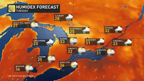
A warm, humid air mass parked over Ontario this week will send temperatures into the upper 20s, with plenty of towns pushing the 30-degree mark for the first time this season. Humidex values will push well into the 30s, especially across the southwest and away from the lakes.
DON’T MISS: Stuck in your car during a tornado? Here’s what you should do
All that instability needs is a trigger to kick off showers and thunderstorms. We’ll have plenty of sparks over the next couple of days to get scattered storms going with the heat of the day.
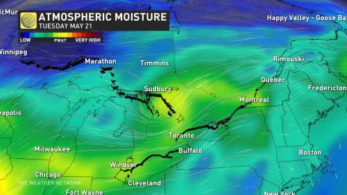
The active weather started Monday as warm front nosed into southern Ontario bringing instability across the region. Tuesday is looking to see more of the same across the Greater Toronto Area.
Below is a break down of what to expect over the coming days.
Storms expected to regenerate on Tuesday
Thunderstorms that bubble up along the warm front over southern Ontario will likely continue into the overnight hours through pre-dawn Tuesday morning.
These storms are expected to arch across southern Ontario while largely missing the Greater Toronto Area (GTA).
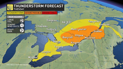
We’ll see the risk for thunderstorms move into eastern Ontario early Tuesday morning as a cluster of storms makes its way east into the region.
Tuesday will see another round of thunderstorms develop with the heat of the day across southern Ontario as that front shifts southeast across the region.
It’s likely this southeastward shift will put the Greater Toronto Area squarely within the risk for non-severe thunderstorms through the day Tuesday, along with the rest of the south. Heavy downpours and strong wind gusts will be the main threats here.
There is a chance some of the storms could reach severe criteria in parts of cottage country and across eastern Ontario. These areas could see large hail, strong winds and heavy downpours, given the amount of moisture storms will be able to tap into.
Another warm front lifting north across the GTA on Tuesday night could serve as the trigger for an additional round of nocturnal thunder over the region.
Remember that even a non-severe thunderstorm is still dangerous. Lightning is the greatest threat posed by any thunderstorm. Stay close to safe shelter if you’re planning to spend time outdoors. If you’re close enough to hear thunder, you’re close enough to be struck by lightning.
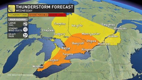
Wednesday’s risk depends on stateside storms
A strong low-pressure system developing over the U.S. Midwest will dictate Wednesday’s storm threat.
Forecasters south of the border expect a potent severe weather event to unfold across the Midwestern states during the day Tuesday.
These storms could include supercells and squall lines capable of producing tornadoes and widespread damaging winds, threatening the major travel hubs of Chicago and Kansas City.
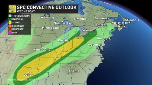
The National Weather Service's Storm Prediction Center (NWSSPC) released an outlook for Wednesday that includes southern Ontario in the marginal, and the extreme southwest in an area of a slight chance of severe storms and large hail. As high-resolution models populate Monday, more confidence will grow to help assess the intensity of the expected storms.
These storms will push east through the evening and nighttime hours, potentially threatening portions of southern Ontario on Wednesday. Temperatures in the upper 20s with high humidex values will support the risk for severe thunderstorms across all of southern Ontario.
MUST SEE: How severe weather alerts are issued, and potentially save lives
The timing of the cold front’s passage, as well as lingering storm activity from Wednesday morning, will dictate the severe thunderstorm potential across the region. Forecasters will closely watch how this setup develops to assess any potential impacts to southern Ontario.
It’s always a good idea to have a safety plan in place for severe weather. Make sure you have a way to receive severe weather warnings the moment they’re issued, especially at night.
Temperatures and humidity levels will both tumble behind the cold front, allowing more seasonable air to spill over the region heading into the end of the week.
Stay with The Weather Network for all the latest on your forecast across Ontario.

