Will more storms, hail hit Dallas-Fort Worth today? Here’s when it will dry out
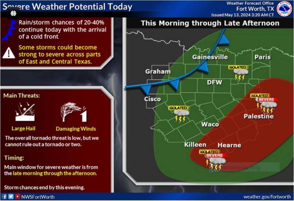
A weak cold front following the storms over the weekend may still have enough strength to roil the weather over Dallas-Fort Worth later Monday morning, according to the National Weather Service Fort Worth office.
This system that wrought severe thunderstorms over western Oklahoma in the past couple of days is what may clipped North Texas with more storms and rain. As of late Sunday night, the weather service kept a flood watch over several counties in the region.
If the system’s convective energy is enough to lift the cap over the region, we may see storms with more large hail and damaging winds. The threat of tornado is low because of the system’s lack of power.
“Large hail and damaging winds are the main threats. The overall tornado threat is low, but we cannot rule out a tornado or two,” according to the NWS. “The highest severe threat will generally be near and east of the I-35 corridor. A chance for severe thunderstorms begins late Monday morning and continues into the afternoon across portions of East and Central Texas.”
⚡ More trending stories from our newsroom:
→ Supermodel Bella Hadid moves to Fort Worth to be with cowboy.
→ If you quit a job in Texas, you could still get unemployment
→ Is this 50-acre Fort Worth ranch really worth $15.9M?
Then things will dry out across the Dallas-Fort Worth area with highs around 85 degrees with light notherly winds.
“Dry and pleasant weather will prevail heading into the midweek period with clearing skies and warmer temperatures for Tuesday. Highs will return to the mid and upper 80s with lows in the 60s,” Fort Worth meteorologist Matt Stalley wrote on the NWS website. “Until then, a mild and muggy morning is in store withwidespread low stratus and perhaps areas of fog set to developthrough daybreak. Some dense fog is not out of the question”

