Minnesota rain totals: Heavy downpours from Tuesday’s storm
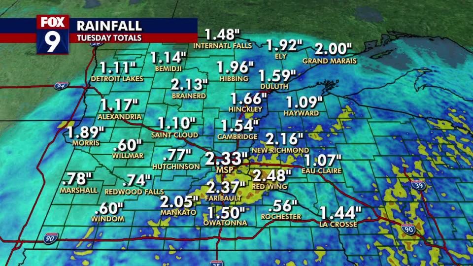
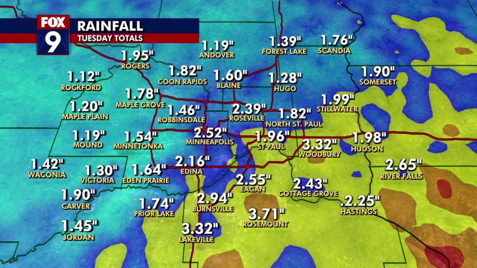
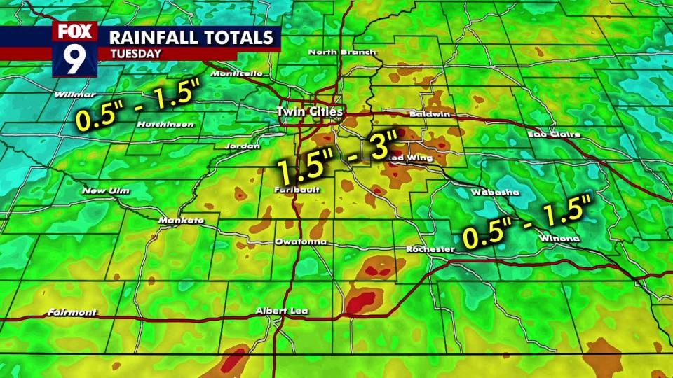
MINNEAPOLIS (FOX 9) - Most of Minnesota received measurable rainfall from Tuesday’s storm, but southern and southeastern parts of the Twin Cities received anywhere from 1.5 to over 3 inches of rainfall.
Rain and storms moved into southern Minnesota Tuesday afternoon, leading to a wet and stormy evening. The storms continued through the evening but moved out of Minnesota as midnight approached.
Heavy rain fell in parts of south and southeastern Minnesota with reports coming in anywhere from around 1.5 to over 3 inches of rainfall. There was a large area of heavy rain in southern and southeastern parts of the Twin Cities along with areas just to the south reporting 2 to 3.5 inches of rain.
Rain totals
Rosemount: 3.71 inches
Woodbury: 3.32 inches
Lakeville: 3.32 inches
Burnsville: 2.94 inches
River Falls: 2.65 inches
Eagan: 2.55 inches
Minneapolis: 2.52 inches
Red Wing: 2.48 inches
Cottage Grove: 2.43 inches
Roseville: 2.39 inches
Faribault: 2.37 inches
MSP Airport: 2.33 inches
Hastings: 2.25 inches
Edina: 2.16 inches
New Richmond: 2.16 inches
Brainerd: 2.13 inches
Mankato: 2.05 inches
Grand Marais: 2 inches
Stillwater: 1.99 inches
Hudson: 1.98 inches
St. Paul: 1.96 inches
Hibbing: 1.96 inches
Rogers: 1.95 inches
Ely: 1.92 inches
Somerset: 1.90 inches
Carver: 1.90 inches
Morris: 1.89 inches
Coon Rapids: 1.82 inches
North St. Paul: 1.82 inches
Maple Grove: 1.78 inches
Scandia: 1.76 inches
Prior Lake: 1.74 inches
Hinckley: 1.66 inches
Eden Prairie: 1.64 inches
Blaine: 1.60
Duluth: 1.59 inches
Minnetonka: 1.54 inches
Cambridge: 1.54 inches
International Falls: 1.48 inches
Robbinsdale: 1.46 inches
Jordan: 1.45 inches
La Crosse: 1.44 inches
Waconia: 1.42 inches
Forest Lake: 1.39 inches
Victoria: 1.30 inches
Hugo: 1.28 inches
Maple Plain: 1.20 inches
Mound: 1.19 inches
Andover: 1.19 inches
Alexandria: 1.17 inches
Bemidji: 1.14 inches
Rockford: 1.12 inches
Detroit Lakes: 1.11 inches
St. Cloud: 1.10 inches
Hayward: 1.09 inches
Eau Claire: 1.07 inches
Owatonna: 1.50 inches
Marshall: 0.78 inches
Hutchinson: 0.77 inches
Redwood Falls: 0.74 inches
Willmar: 0.60 inches
Windom: 0.60 inches
Rochester: 0.56 inches
Severe weather, storm damage in the Midwest
Southern Minnesota was bracing for the potential of damaging winds Tuesday, as severe weather moved across much of the state. The impact of the storms, however, was minor and there were very few reports of damage.
Several counties south of the Twin Cities metro had reports of downed trees and power lines, and thousands were without power for at least part of the afternoon.
However, the worst of the damage appeared to be focused in Iowa, where multiple tornadoes were reported. The Iowa State Patrol said multiple deaths have been reported after a tornado ripped through the small City of Greenfield. Iowa authorities say they don't have a definitive count of the fatalities as of Tuesday night.
As of Tuesday evening, 33 tornadoes had been reported across the Midwest, mostly in central and western Iowa.
Wednesday's forecast
Wednesday is expected to be cooler, brighter, and breezy, but isolated thundershowers may occur later in the day.
Wednesday will feature more sunshine and passing clouds. It will be rather breezy with westerly winds at 15-30 mph. Temperatures are closer to seasonable for a high of around 71 degrees in the metro area.
The day will stay mostly dry, but a few isolated thundershowers may pop up near or north of Interstate 94 later in the late afternoon. These will mostly stay in north central Minnesota but could make an appearance in the Twin Cities metro area.

