Mighty East Coast storm elevates power outages, risk of travel issues

A potent storm with spring and winter-like characteristics continues to flex its muscles across Atlantic Canada Sunday, with thousands of customers still without power in the Maritimes amid the poor conditions.
As of Sunday afternoon local time, just more than 7,000 Nova Scotia and 3,000 New Brunswick customers sit in the dark. With intense wind gusts ongoing, power outage numbers are likely to continue fluctuating.
MUST SEE: Rare widespread chill to hit Canada, kicking off an active pattern
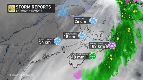
Rainfall and snowfall totals are starting to pour in. In Nova Scotia, rainfall totals of 48 mm in East Kemptville and 47 mm in New Tusket have been documented. In New Brunswick, 26 cm of snow has been measured in Miramichi so far.
Also, with the snow, rain and mixed precipitation on Sunday, residents are advised to stay off the roads unless absolutely necessary. If travel is unavoidable, use extreme caution, prepare for road closures, and check road conditions along your route.
Sunday: Heavy snow, blustery winds and rain spread across the Maritimes
Cold air over the northern Maritimes made this an all-snow event for much of New Brunswick, while warmer air pushing in from the ocean led to rain and mixed precipitation for Nova Scotia and the Bay of Fundy.

As snowfall departs New Brunswick, some initial reports have trickled in. Northwest of Fredericton, nearly 20 cm was reported near Keswick Ridge. Farther northeast of there, 26 cm of snow was measured in Miramichi while 17 cm was observed in Edmundston by a local volunteer.
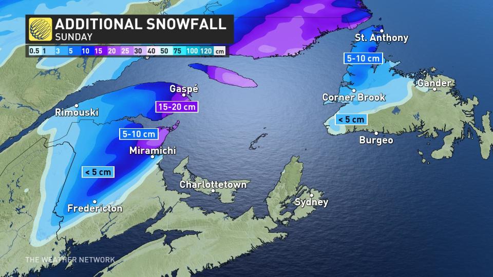
Most of it has already fallen, with an additional 5-10+ cm forecast on Sunday.
Drivers are urged to plan ahead and to adapt to deteriorating road conditions. The heavy, wet snow and icy conditions could also heighten the risk for power outages.
Wind gusts up to 100 km/h are possible Sunday morning as the core of the storm moves through the region. This will increase the risk for power outages, especially alongside the weight of the snow and ice on limbs and power lines. Rain-soaked soils will make it easier for trees to fall in the blustery conditions.
Rain will pose the primary threat for communities across southern New Brunswick and much of Nova Scotia. Heaviest rainfall will move east of Halifax on Sunday morning, with close to 30 mm already recorded. The highest totals documented include 48 mm in East Kemptville and 47 mm in New Tusket.
A brief period of mixed precipitation in in northern Nova Scotia as the system slides out of the Maritimes.

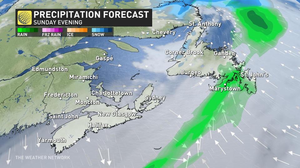
Meanwhile, as the system moves farther east, showers will shift to Newfoundland Sunday evening.
An additional 30-50 mm of rainfall is anticipated for southwestern New Brunswick and Nova Scotia, with 20-30 mm for Halifax and surrounding regions. As much as 30-40 mm is expected for western Newfoundland.
Localized flooding is possible in low-lying and vulnerable areas.
Another wet system will be bring rain for the next five days across the Maritimes, adding to the accumulations seen across Nova Scotia.
Stay with The Weather Network for all the latest on your forecast across Atlantic Canada.

