Midwest, Ohio Valley to face bouts of strong storms into Monday night
While one storm system brings an outbreak of severe weather to the central United States into Monday night, another will trigger a separate region of strong storms in the Midwest and Ohio Valley.
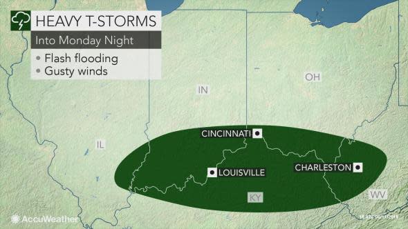
The threat zone east of the Mississippi River will shift farther to the south and east and include cities such as Louisville, Kentucky; Cincinnati, Ohio; and Charleston, West Virginia.
The greatest threat is likely to be related to heavy rainfall.
Because a swath from the Iowa/Illinois border through much of Indiana and Ohio have received a general 1 to 3 inches of rainfall over the past week, any additional rainfall will make flash flooding an imminent threat.
"Storms into Monday night will continue to bring heavy rainfall across the Interstate 64 corridor from southeastern Illinois to West Virginia," AccuWeather Meteorologist Brett Edwards said.
Edwards added that a general half inch to one inch of rain should fall along this swath into Monday night, with localized amounts up to 2 inches.
Because it will only take 1-2 inches of rain in a three-hour time period to trigger flash flooding along streams and creeks in these areas, flooding will be the most widespread concern into Monday night.
Roadways can quickly become submerged when prolonged downpours repeatedly strike the same area.
Motorists may face significant delays during Monday afternoon's commute, and those delays can filter over into air travel as well.
Never attempt to drive through a flooded roadway; instead, seek an alternative route.
It only takes 1 foot of water to float most vehicles, and 2 feet of moving water can sweep most vehicles away.
In addition to the heavy rainfall, storms will also bring the threat for strong wind gusts.
Broken tree limbs and sporadic power outages may occur in areas hit by the strongest storms.
All residents from eastern parts of the Midwest to the mid-Atlantic should remain cognizant of the latest severe weather alerts through Monday night and move indoors into an interior room or basement when severe weather strikes.
It may be tempting to capture footage of a powerful thunderstorm, but standing near a door or window or even outside during a storm greatly increases the risk of injury from lightning or flying debris.
On Tuesday, part of the same area of the Ohio Valley will be at risk for strong thunderstorms and flash flooding.
