Mid-April storm to eye California with rain, mountain snow

 |
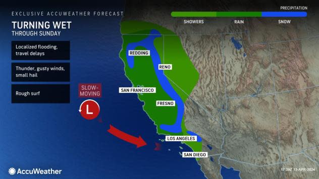
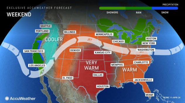
Even though Pacific storms have become less frequent, as is often the case in April, a new storm will slice across California this weekend, bringing areas of rain, mountain snow, thunderstorms and much cooler air, AccuWeather meteorologists say.
April marks a typical downturn in the number of storms and opportunities for rain and snow in California, but the atmosphere is continuing its generosity this month following a storm-rich winter season.
"The angle at which the storm is moving in from the Pacific Ocean will make this mostly a California event and not a northwestern United States event," AccuWeather Senior Meteorologist Heather Zehr said.
 |
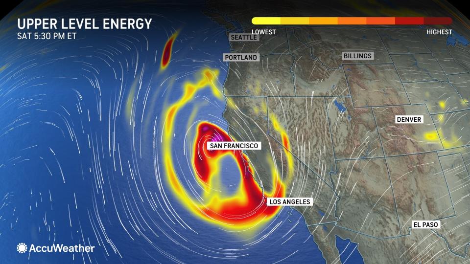
The first showers from the storm affected parts of Northern California and southern Oregon on Friday. As the storm drops to the south-southeast, the shower activity will evolve into areas of steadier rain and spread across much of California into Saturday night, along with cooler air.
The wettest time frame for the storm in the state overall is Saturday, but that may be skewed to late Friday night to Saturday midday around San Francisco and from later Saturday to Saturday night from Los Angeles to San Diego, Zehr said.
"This will not be a major rain event for most of Southern California with a few exceptions," Zehr stated. "The area from near Point Conception to Santa Barbara and Ventura counties [stands] the best chance of regional flash flooding problems."
Elsewhere, any flash flooding will be extremely isolated or limited to spotty street flooding and some brief ponding on stretches of highways with poor drainage.
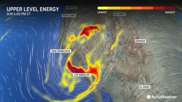
Regarding snowfall, freezing levels will start rather high as the storm moves in through Saturday but will drop considerably from Saturday to Sunday as the storm turns inland over California.
 |
"Snow levels are likely to dip between 4,000-5,000 feet in the southern Sierra Nevada as well as the Transverse and Coastal ranges in Southern California as well," Zehr explained.
A few inches to perhaps a foot of snow may fall over the high country of the Sierra Nevada from the weekend storm.
Compared to most storms this past winter, including some that have dumped several yards of snow on the Sierra Nevada, this storm will be more of a minor problem for travel in terms of snow over Donner Pass, California.
 |
In terms of rainfall and the liquefied amount of snow that has fallen since the start of the rain year last July 1, downtown Los Angeles has received 24.53 inches of rain, which is 180% of the historical average. Rainfall in much of Southern California has ranged from 125-200% of average. In Northern California, the amount of rain and melted snow has been fairly close to the historical average.
This means that California has had two winter seasons in a row where precipitation has been average to well above the historical average, putting the state in a position to be free of water shortage problems for an extended period.
Earlier this winter, AccuWeather's team of experts released a statement that California would be free from weather-related water shortages into the spring season of 2025 because of prior, ongoing and anticipated storms. AccuWeather later extended the water-shortage-free statement this spring through the winter and into the spring of 2026.
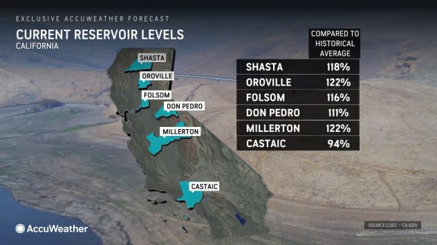
The vast majority of reservoir levels in the state are currently well above the historical average for April, according to the California Department of Water Resources.
 |
Meanwhile, water levels on Lake Mead in Nevada continued to run well above last year and 2022. The man-made lake created by Hoover Dam reached extremely low levels in July of 2022 at 1,041 feet. Levels as of Friday, April 12, 2024, were 33 feet higher, near 1,074 feet, and were 28 feet above levels around the same date in April last year.
The storm coming in this weekend will be vigorous enough to generate locally gusty winds along the coast and over the ridges. The storm's circulation will produce a period of rough surf and occasional large waves that can lead to overwash in some beach communities. Because the storm is dropping southward and has not had much time to gather swells from well out over the Pacific, wave action along the coast should not be as intense or damaging as a few storms from the middle of the winter.
The overall structure of the storm may still allow spotty gusty thunderstorms with small hail to develop in some locations. In a few spots, the hail could cover the ground.
This weekend's storm will end the warming trend that began this week in California.
 |
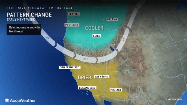
However, the chilly trend will be temporary. The storm will push inland early next week, allowing temperatures to moderate and some sunshine to return.
Meanwhile, a moisture-laden storm was drenching parts of Hawaii to end the week. The slow-moving storm will continue to produce a firehose of downpours that will meander back and forth across some of the islands, especially from Kauai to Oahu and Maui, through Sunday.
Want next-level safety, ad-free? Unlock advanced, hyperlocal severe weather alerts when you subscribe to Premium+ on the AccuWeather app. AccuWeather Alerts™ are prompted by our expert meteorologists who monitor and analyze dangerous weather risks 24/7 to keep you and your family safer.