Met Office issues yellow weather warnings as thunderstorms set to hit UK
The Met Office has issued two yellow weather warnings as thunderstorms are set to batter parts of the UK on Wednesday.
Travel disruption and flooding are expected as the south of England and southeast Wales are expected to take the greatest hit from the May washout.
Between 20 to 40mm of rain is likely to fall over a three-hour period later this evening, with 50mm expected in some places.
“Spells of heavy rain are expected this evening and overnight. In some places, most likely over northern and eastern parts of the warning area, there is a chance that rain will be accompanied by thunderstorms and frequent lightning,” the Met Office said.
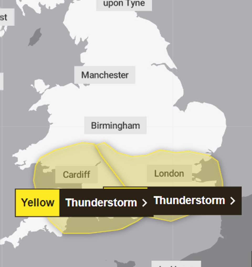
The first weather warning is in force from 8pm on Wednesday until 8am Thursday and covers large swathes of south west England and Wales.
The second warning, in place from 11pm Wednesday until 6am Thursday, affects large areas of the east and southeast of England, including London, and the west Midlands.
⚠️ Yellow weather warning issued ⚠️
Thunderstorms across southwest England and south Wales
Wednesday 2000 – Thursday 0800
Latest info 👉 https://t.co/QwDLMfRBfs
Stay #WeatherAware⚠️ pic.twitter.com/0VRlNJCwEf— Met Office (@metoffice) May 1, 2024
The storm brings a risk of flash flooding and power cuts, the Met Office warned, which could result in road closures and train or bus cancellations.
Met Office meteorologist Alex Deakin said: “You may well get woken up tonight by a rumble of thunder, or some flashes of lightning across parts of the south.
“A lot of heavy rain falling in a short space of time as well.”
There will still be some “heavy bursts of rain” early on Thursday across the southwest, Mr Deakin said, but the weather is set to brighten up as the day goes on.
He added: “Parts of northwest Scotland, Northern Ireland, northwest England, much of the Midlands down towards East Anglia should have a fine and sunny day tomorrow.”
Met Office five-day forecast
Tonight:
Heavy rain and potential thunderstorms moving across central and southern parts of England and Wales. Dry elsewhere with mist and low cloud becoming quite widespread in the north and east.
Thursday:
Further rain across the south and southwest, with the risk of thunder later. Otherwise largely dry with low cloud gradually clearing. Warm for many but cool along North Sea coasts.
Outlook for Friday to Sunday:
Remaining changeable with further spells of rain or showers, particularly in the south. In any drier and brighter interludes it will feel warm away from the east coast.

