Quebec, Atlantic Canada get a messy, wintry system to kick off the spring season
With Quebecers legally free to remove their winter tires, it's definitely a wise idea not to do so just yet.
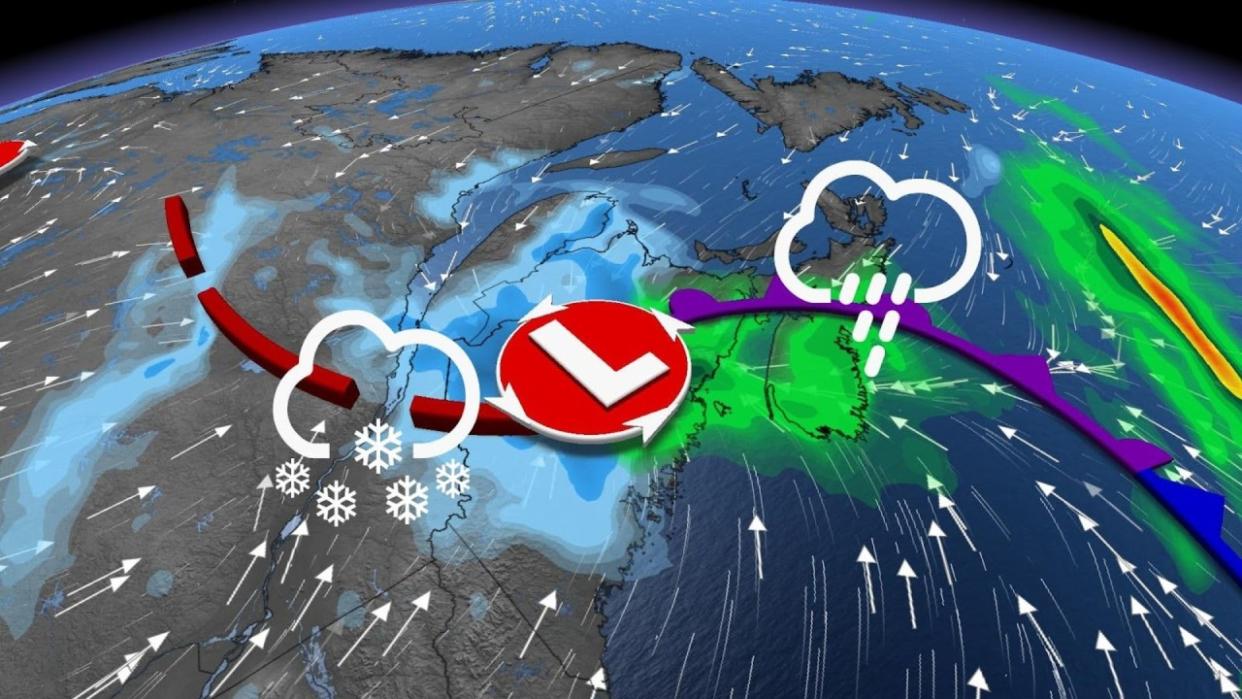
Even though Wednesday is the first full day of spring, wintry systems moving into eastern areas through Thursday will spoil any plans to celebrate it outdoors. Northern New Brunswick will also be impacted, with a considerable amount of snow and gusty winds.
SEE ALSO: Quebecers can legally remove winter tires soon, but should they?
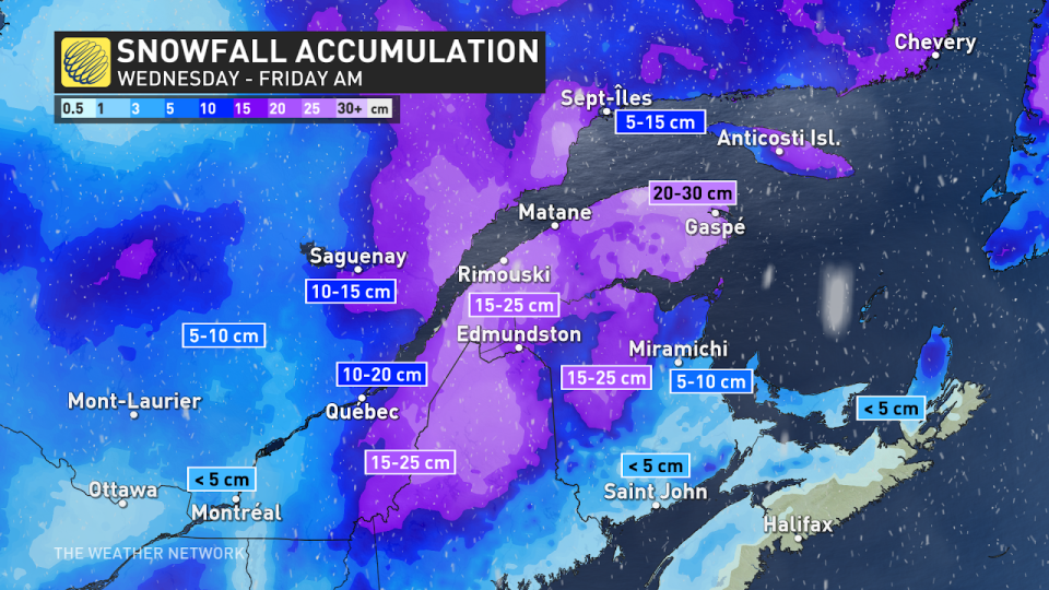
A swath of heavy snow and strong winds will be dragged along with the lows into eastern Quebec and northern New Brunswick. Anywhere from 15-30 cm of snowfall is expected through Friday morning, so plan ahead and brace for difficult driving conditions.
Through Friday morning: Heavy snow and blustery winds push through
The first day of spring will see the first low-pressure system bring just some scattered flurries to Quebec City and northern New Brunswick Wednesday afternoon and evening, serving as an appetizer for the next disturbance.
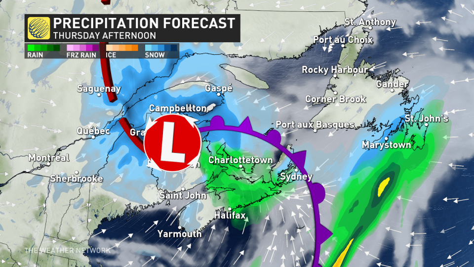
A clipper is then expected to develop and track in from New England, reaching parts of Eastern Canada Wednesday overnight through Thursday night, bringing widespread, windy conditions, and heavy snow for northern New Brunswick, parts of eastern Quebec and western Newfoundland.
Snow will accumulate rather quickly, so conditions will change in a hurry. If you need to be on the roads, consider shifting plans to avoid the worst of it while driving.
The heaviest snowfall for Quebec City and the Eastern Townships will be from Wednesday overnight into Thursday afternoon, with Quebec City likely to see around 10 cm of snow. For northern New Brunswick and the Gaspé Peninsula, the worst of it will be Thursday morning and afternoon.
Snowfall rates will range from 1-3 cm an hour on average, but in intense bands, they could reach as high as 5 cm an hour.
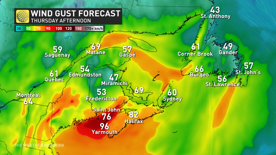
Wind gusts will pick up through the day Thursday, ranging from 40-60 km/h, meaning poor visibility on the roads, so travel is not recommended.
Southwest Nova Scotia and the Bay of Fundy will be even more battered by the winds on Thursday, with gusts reaching 70-90+ km/h.
Flurries will linger overnight Thursday and through Friday morning before easing for the afternoon.
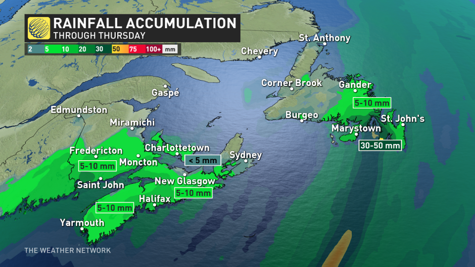
As the system moves northeast through Thursday, folks on the Avalon Peninsula can expect to see heavy rain rather than snow. With 30-50 mm of rain in the forecast, rainfall warnings have been issued for the Avalon.
Beyond, forecasters are closely watching the track of a storm that is expected to track up the U.S. East Coast this weekend and reach Atlantic Canada, with mostly rain for southern areas, snow for northern areas and a messy mix of snow, rain and possibly ice in between.
The track and impacts of this system will highly depend on whether this storm merges with the system that tracked across southern Ontario. Another messy system is expected early or the middle of next week with a risk for freezing rain for parts of the Maritimes.
Stay tuned to The Weather Network for the latest forecast updates for Eastern Canada.

