Memorial Day Weekend Forecast: What DC region can expect
WASHINGTON - It is hard to believe that the Memorial Day holiday weekend is just around the corner! Spring has flown by, and aside from a lot of wet weekends, it has gone by quietly in terms of powerful storms and severe weather.
When it has rained though, Mother Nature has been a little cruel to our region, as a lot of it has come on weekends. In fact, 15 of 20 weekends so far in 2024 have featured some sort of measurable rainfall, including every single weekend in the month of May. With a holiday weekend approaching, will we break out of that pattern? Or keep it going?
A nice difference between this week and last week will be more sunshine! An upper atmospheric ridge has expanded northward out of the south. Under these ridges, you get more broad sinking air, which promotes more sun as opposed to the gray, gloomy days we dealt with much of last week in the D.C. region.
With more sunshine comes warmer temperatures, however, and it may start feeling like summer around here once again by the middle of the workweek. Wednesday and Thursday could both see high temperatures flirting with the 90 degree mark once again here in the nation’s capital.
Unfortunately, it's not just heat that we will have to contend with, but humidity as well. In fact, by Wednesday night and Thursday, dew points may be right around 70 degrees in our area, which is the middle of summer levels of humidity. The heat index on Thursday could be well into the 90s. As most area pools will not be open just yet, you will want to find a nice place to cool off, such as the Georgetown or Wharf splash parks.
If you are not able to though, Mother Nature may provide a splash park of her own. Thunderstorms are likely, particularly on Thursday afternoon where a few could be on the strong side. Sadly, that is a forecast that may repeat heading into the holiday weekend. Following Thursday's risk for showers and thunderstorms along a cold front, a secondary cold front will cross on Friday and bring another chance for showers and a few storms.
This front is than expected to stall across parts of the Mid-Atlantic region. Meanwhile, about 20,000 feet above our heads, our upper-level ridge that bought the early week sunshine will be breaking down, while a feature known as a "shortwave" will cross the country from west to east. With the stalled front in place, this will cause several areas of low pressure to develop and ride along this frontal boundary, leading to more chances for showers and thunderstorms through the holiday weekend.
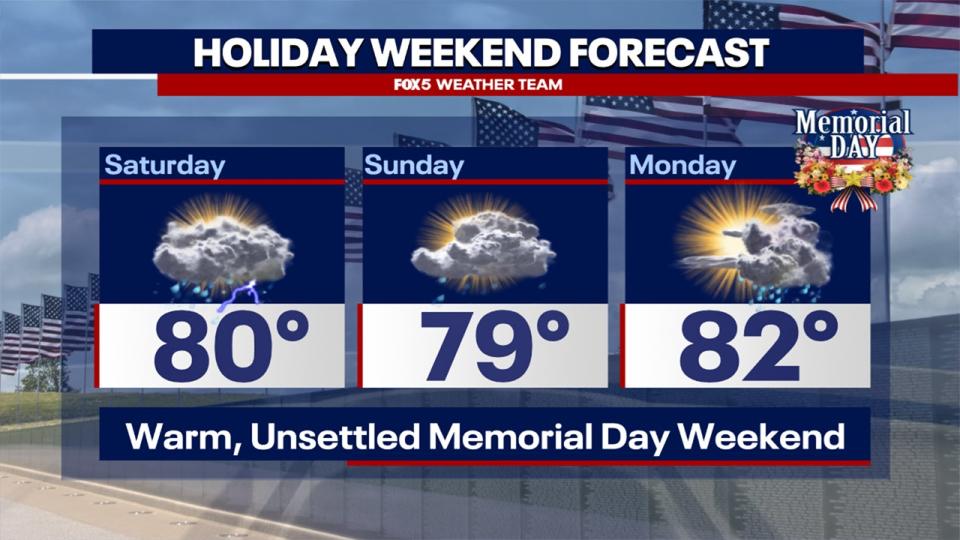
As this stage, Saturday and Monday appear to have the highest threats for the most widespread shower and thunderstorm activity. None of the days look like complete washouts, and some sun will inevitably break through, but compared to the first half of the week which looks to be more sun positive, we will fight more cloud cover through the course of the holiday weekend. While temperatures will be naturally cooler, humidity will remain high through the weekend, which will further promote the unsettled conditions.
Now it should be mentioned that the forecast for this range is a low confidence one. We can get an idea of which days will be unsettled, but there is still time for things to change. The position of the stalled front will be key to how widespread storms will be this weekend, and we will continue to keep you posted on how this pans out throughout the course of this week.
Loving the sunshine? Well you got more of it coming your way tomorrow. Can we put together a dry streak heading into the big holiday weekend...or will the "gloom" return? We're looking ahead on @fox5dc at 10pm! pic.twitter.com/zVCxpiRdKg
— Mike Thomas (@MikeTFox5) May 21, 2024

