Massive Typhoon Tembin Snapped from Space

A huge and powerful typhoon is churning toward China, putting the storm-weary nation on alert. Typhoon Tembin is the fifth massive storm to hit the region in three weeks, and residents are bracing for yet more drenching rains and high winds as the typhoon approaches.
The storm is packing maximum sustained winds of 115 mph (185 kph) with gusts up to 144 mph (230 kph), according to the latest forecast from the U.S. Navy’s Joint Typhoon Warning Center, making it the equivalent of a Category 3 hurricane. (Typhoons are the same phenomenon as tropical storms and hurricanes, all collectively known as tropical cyclones.)
The latest outlook has the storm poised to sweep across Taiwan and continue on toward the mainland, curving south toward Hong Kong in the coming days.
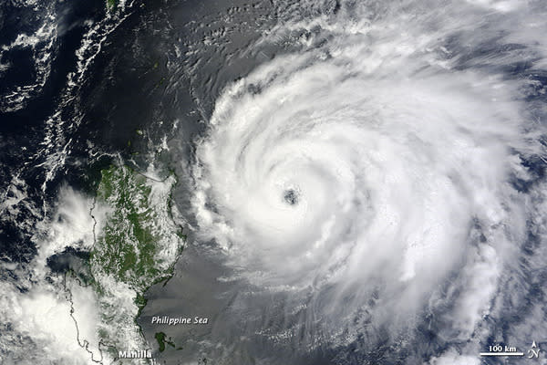
A satellite image snapped yesterday (Aug. 20) shows the storm hovering near the Philippines. Although the storm didn't make landfall, it did trigger damaging landslides and floods in the island nation.
The storm has since moved northward toward Taiwan, putting the island directly in its path.
Since the start of August, four typhoons have made landfall in China. Tembin is following Typhoons Saola and Damrey, which hammered the region one after the other in the first week of August. Typhoon Haikui hit just a few days later, followed by Typhoon Kai-tak.
Typhoon Tembin is the 14th named storm of the 2012 Pacific typhoon season.
Follow OurAmazingPlanet for the latest in Earth science and exploration news on Twitter @OAPlanet. We're also on Facebook & Google+.
Copyright 2012 OurAmazingPlanet, a TechMediaNetwork company. All rights reserved. This material may not be published, broadcast, rewritten or redistributed.
