Hurricane Maria becomes 'extremely dangerous' Category 4 storm as it bears down on Caribbean islands battered by Irma
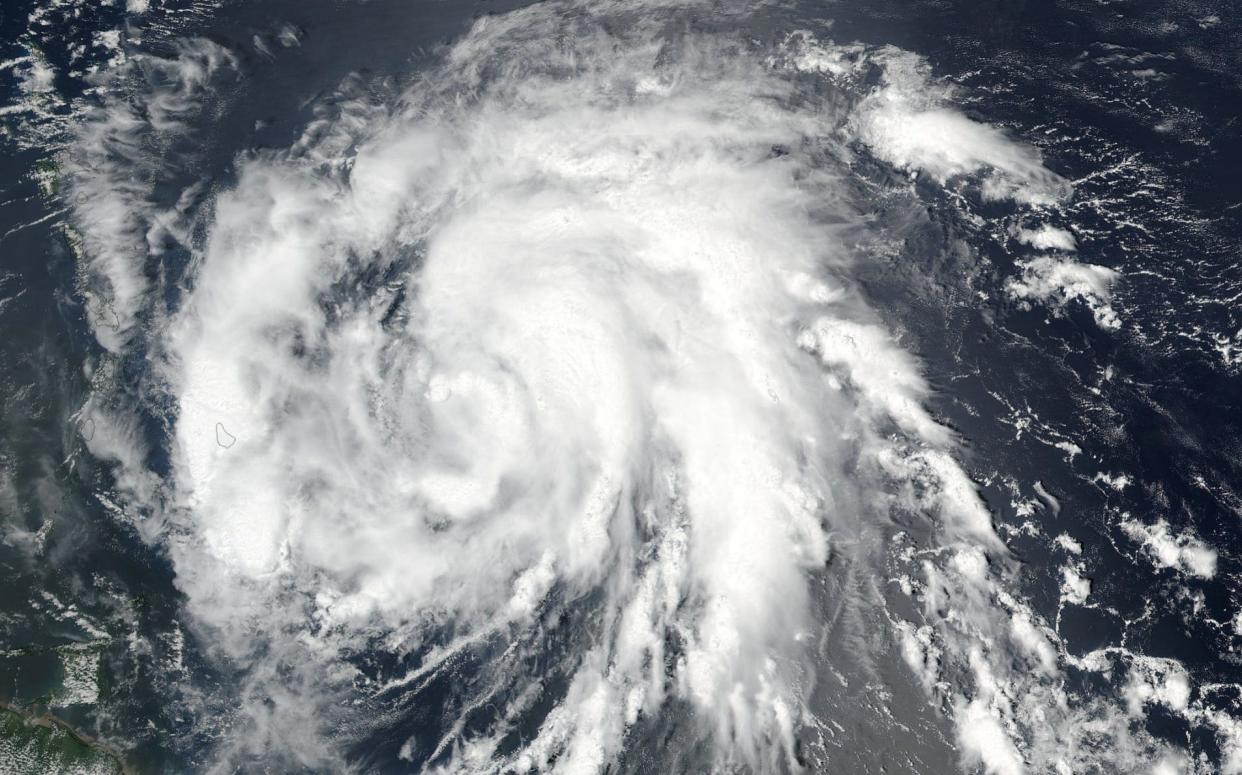
Hurricane Maria strengthened into an "extremely dangerous" Category 4 storm on Monday as it barreled toward the Caribbean island of Dominica, the US National Hurricane Centre said.
According to the centre Maria was already packing winds of 130 mph.
On the French island of Guadeloupe, the prefect ordered mandatory evacuation of areas at risk.
Officials said the French Caribbean island would experience extremely heavy flooding starting on Monday afternoon, and they warned that many communities would be submerged overnight.
The storm was on a path that would take it near many of the islands already wrecked by Hurricane Irma and then on toward Puerto Rico, the Dominican Republic and Haiti. Maria could hit Puerto Rico on Wednesday as a Category 3 or 4 hurricane, said Ernesto Morales with the US National Weather Service in San Juan.
"This storm promises to be catastrophic for our island," he said. "All of Puerto Rico will experience hurricane force winds."
Evacuation orders have been issued for part of the island as it braces itself for up to 18 inches of rain.
People in low lying areas of Antigua and Barbuda were urged to evacuate, rather than wait until the last minute.
Hurricane warnings were posted for Guadeloupe, Dominica, St. Kitts, Nevis, Montserrat, Martinique and St. Lucia. A tropical storm warning was issued for Antigua and Barbuda, Saba, St. Eustatius and St. Maarten.
Watch live: Track path of Hurricane Maria
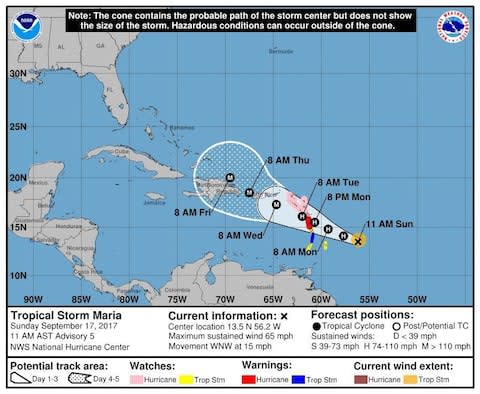
The US National Hurricane Centre said Maria was centered about 60 miles (95 kilometers) east-southeast of Dominica - or 85 miles (135 kilometers) east of Martinique - and heading west-northwest at 12 mph (19 kph).
"Additional strengthening is forecast during the next 24 to 36 hours, and Maria is expected to be an extremely dangerous major hurricane during the next couple of days."
First landfall is expected around 8 p.m. local time in the northeast Caribbean's Leeward Islands -- specifically Dominica and Martinique.
Hurricane conditions should begin to affect parts of the Leeward Islands by Monday night, with storm surge raising water levels by 4 to 6 feet (1.2 to 1.8 metres) near the storm's center. The storm was predicted to bring 6 to 12 inches (15 to 30 centimetres) of rain across the islands, with more in isolated areas.
On Wednesday, Maria was expected to be near or over Puerto Rico, which was spared the full brunt of Irma, although much of the island had its power knocked out. Nearly 70,000 people remain without power, and the governor, Ricardo Rossello, warned on Monday of another widespread outage.
"We have an extremely weak infrastructure that has already been hit by one storm," he said. "This is going to be a catastrophic event."

Officials said the Federal Emergency Management Agency was ready to bring drinking water and help restore power in Puerto Rico immediately after the storm.
Mr Rossello said officials had prepared about 450 shelters with a capacity for nearly 68,000 people - or even 125,000 in an emergency. Schools were cancelled for Monday and government employees would work only a half day.
Officials in the Dominican Republic urged people to leave areas prone to flooding and said fishermen should remain in port.

Farther north, long-lived Hurricane Jose continued to head northward off the US east coast, causing dangerous surf and rip currents. It wasn't expected to make landfall but tropical storm watches were posted along the coast from Delaware to Cape Cod, Massachusetts.
Jose was centered about 270 miles (440 kilometres) east-southeast of Cape Hatteras, North Carolina, and was moving north at 9 mph (15 kph). It had maximum sustained winds of 85 mph (140 kph).
In the Pacific, Tropical Storm Norma's threat to Mexico's Los Cabos resort area at the southern end of the Baja California Peninsula seemed to ease as forecasters said the storm's centre was likely to remain offshore.
Norma had winds of about 65 mph (105 kph) and it was centered about 160 miles (255 kilometres) southwest of Cabo San Lucas. The Baja California Sur state government prepared storm shelters and cancelled classes for Monday.
Meanwhile, Tropical Storm Lee weakened into a tropical depression far out in the Atlantic while Hurricane Otis weakened far out in the Pacific. Neither threatened land.


