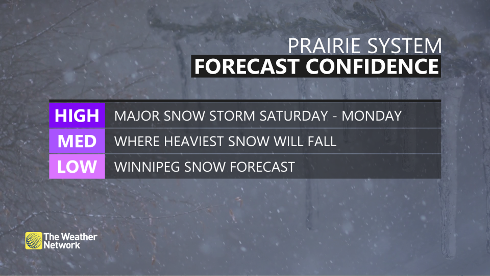
March roars in like a lion on the Prairies with major snowstorm
March rolled in across Canada with quite a contrast between warm and cool weather.
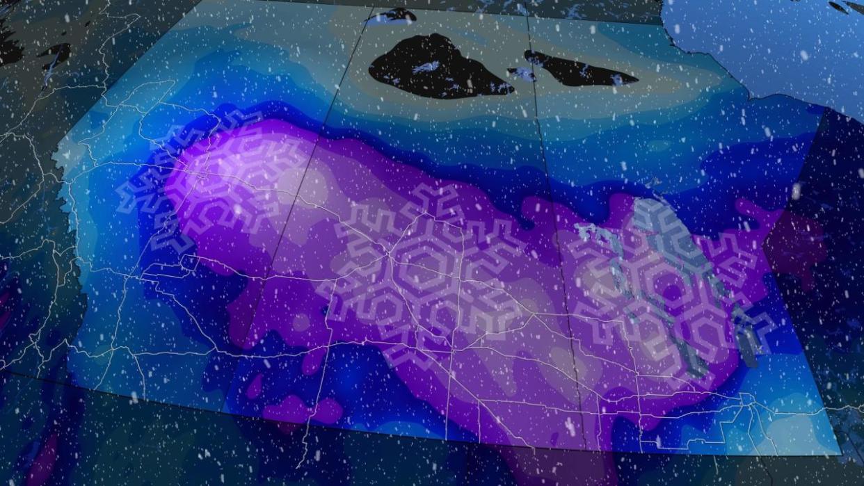
Unfortunately, for the Prairies, they are on the latter side of that divide –– accompanied by a major storm that threatens to bring 40+ cm of snow for some areas through this weekend. Coupled with blustery wind gusts of 50-70 km/h and blowing snow, blizzard conditions are possible for many areas.
SEE ALSO: Expect a turbulent March across Canada as the seasons duke it out
A large swath of winter storm warnings and watches, along with snowfall and blizzard warnings, and special weather statements are in place across the three Prairie provinces.
Expect travel to be highly interrupted during the storm. Consider postponing non-essential plans until conditions improve. Public Safety Canada encourages everyone to make an emergency plan and get an emergency kit with drinking water, food, medicine, a first-aid kit and a flashlight.
Saturday sees snow push in, storm will then peak on Sunday
We’ll watch a Montana low continue to organize and spread north Saturday, bringing snowfall across Alberta and Saskatchewan by the afternoon and evening.
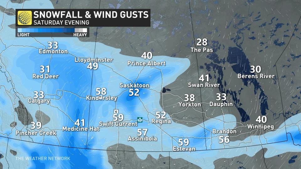
Cold temperatures across the western half of the Prairies will make this a light and fluffy snow, which accumulates in a hurry and easily blows around in gusty winds.
Folks across Alberta will see snowfall ease on Sunday as the system continues to strengthen and push east across Saskatchewan and into southern Manitoba.
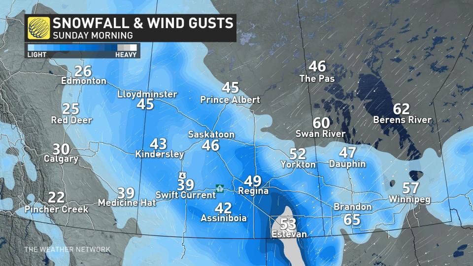
Heavy snow is likely across much of southern portions of Saskatchewan and Manitoba by Sunday morning, continuing through the day. Very heavy snowfall rates of 5+ cm per hour are possible along the Yellowhead Highway during the storm’s peak on Sunday.
WATCH: Saskatchewan and Manitoba brace for blizzard conditions throughout the weekend
Blowing snow a significant concern for weekend travel
Gusty winds of 50-70 km/h will accompany the heavy snowfall across the region, leading to extended periods of severely reduced visibility. Blizzard conditions will continue through Sunday and end Monday morning.
Complete whiteouts are possible at times. Travel will be difficult if not impossible on all roads across the region during heavy snow and high winds.
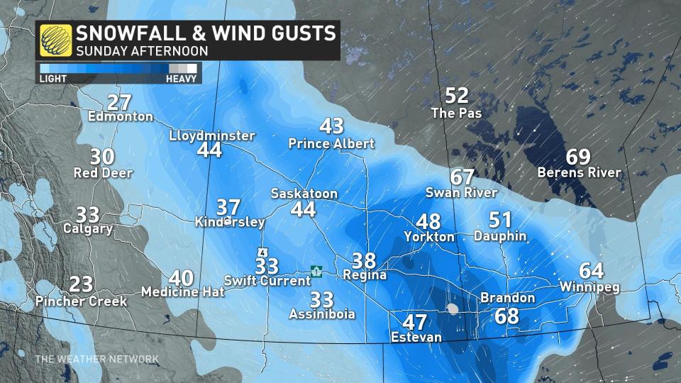
Rapidly accumulating snow and poor visibility will make travel difficult or nearly impossible, especially along the Yellowhead. Travellers along the Trans-Canada Highway in Saskatchewan and Manitoba will also have to contend with heavy, blowing snow.
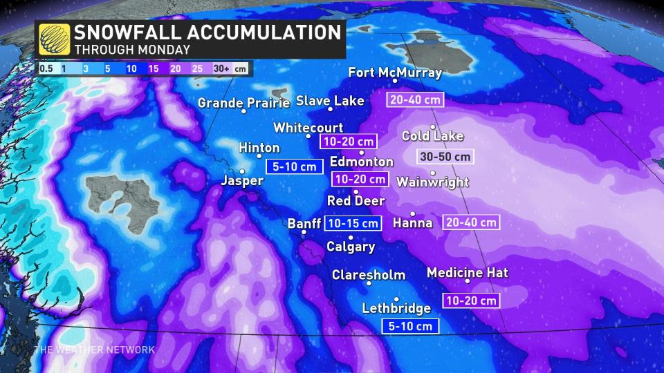
Snowfall totals of 40+ cm are possible
The greatest accumulations in Alberta will largely miss the QE2, with 10-15 cm in the forecast across Calgary, and potentially as much as 20 cm for Red Deer and Edmonton. Farther east, we could see well over 20 cm of snowfall by the end of the weekend around Oyen and Cold Lake, with totals of 40+ cm possible around Lloydminster.
RELATED: Avalanche warning issued as snow piles up in the Rockies
Since the snowfall is anticipated to be light and fluffy, accumulations will likely exceed forecast amounts in some areas.
Forecasters expect the heaviest snowfall totals to target central and southern Saskatchewan, and southwestern Manitoba, where 20-40+ cm of snow is possible by the time precipitation wraps up on Monday.
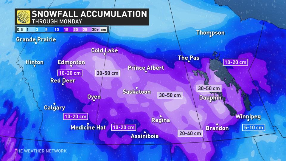
Folks around Regina in the south could see 15-30 cm of snow by Monday. It would only take a slight shift in the storm's track to bump these higher totals toward the north or south.
The greatest uncertainty surrounding this storm is the potential for a sharp cutoff in snowfall totals around Winnipeg. That is due to the centre of low tracking across the Red River Valley, and as it does so, pulls in warmer air with it and will elevate the risk of a wintry mix.
This intrusion of warm air into southern Manitoba could force a changeover to ice pellets in and around Winnipeg, which would significantly cut down snow accumulations here. Warmer temperatures will also make for wetter snow in Manitoba as opposed to the light and fluffy powder expected to the west.
Snow continues Sunday overnight, then becoming lighter by Monday morning. It will end in the afternoon as it moves northeast.
Stay with The Weather Network for all the latest on this snowstorm across the Prairies.

