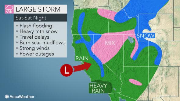
Major California storm to unleash flooding rain, feet of mountain snow and strong winds this weekend
One of the most potent storms of the winter will continue to trigger flooding rain, mudslides, heavy mountain snow, strong winds and difficult to dangerous travel in California and much of the West this weekend.
Click here for the latest reports.
Rain and mountain snow will spread inland through Saturday. Areas of rain and snow may persist not only on Sunday but into next week as well.
Download the free AccuWeather app to see when rain or snow will arrive in your area and be notified of imminent dangers.
Expect flooding rain, mudslides with this storm
The amount of rain from the storm is more than enough to cause flash and urban flooding problems and trigger mudslides and rock slides. The mudslide risk will be greatest in, but not limited to, recent burn scar locations.
Evacuations in burn scar areas may be necessary. Several evacuation warnings have already been issued.

"Several inches of rain will fall on the west- and south-facing slopes of the coastal mountains and foothills and lower elevations of the Sierra Nevada this weekend," according to AccuWeather Senior Meteorologist Brett Anderson.
An AccuWeather Local StormMax™ of 8 inches of rain is forecast through Saturday night with some additional rain likely into early next week.
"A general 1-2 inches of rain with local amounts to 3 inches will fall on San Francisco, Los Angeles and San Diego," Anderson said.
The worst conditions on the roads and at the airports will be through Saturday around San Francisco and from Saturday to Saturday night in Sacramento, Los Angeles and San Diego.
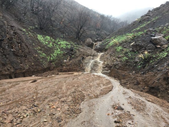
Part of SR-23 were closed due to mudslides during a mid-January 2019 storm. Crews worked to clear the roads of all debris and mud. (Photo/Caltrans District 7)
Gusty winds to accompany the storm
Strong winds will accompany the rain along the coast and at intermediate elevations in the mountains. Gusts may reach 60 mph, which can bring down trees and cause power outages.
Large waves will pound the coast and may result in erosion and dangerous conditions. Sneaker waves may hit without notice and pose serious risk for onlookers. Conditions may be life-threatening for those venturing into the surf.
Several feet of snow to fall on the Sierra Nevada
Heavy snow is forecast for the mountains.
"Several feet of snow is expected to pile up in the Sierra Nevada," according to AccuWeather Senior Meteorologist Bernie Rayno.
"While the snow will be a further boost in the snowpack and add to the tremendous bases of snow at the ski resorts, it will lead to major travel disruptions," Rayno said.
All snow is forecast for Donner Summit; farther south, while rain will fall on the Grapevine initially, freezing levels will lower as the storm progresses.

Travel may become impossible for a time at the height of the storm from Saturday afternoon into Sunday. As winds increase with the snow, blizzard conditions will evolve with extensive drifting snow that may make it impossible for crews to keep up with. Officials are discouraging travel over Donner Summit during the storm.
As colder air sweeps in toward the end of the storm on Sunday, snow showers may cause slippery conditions over Tejon and Cajon passes.
During Monday and Tuesday, a weaker but colder storm is forecast to drop southward along the coast and bring rain showers at low elevations and snow showers to the mountains, including the passes in Southern California.
"By the middle of the week, there may be 7 feet of new snow on the ground over the ridges and peaks of the Sierra Nevada," Rayno said.
Storm, colder air to spread over the interior West
As the storm pushes inland over the weekend, rain and lowering snow levels will spread across the interior West with deteriorating travel conditions over the Interstate 15, 40, 70, 80, 84 and 90 corridors.
Drenching rain with the risk of localized flooding is forecast for Las Vegas while a few rain showers are likely for Phoenix for the first part of the weekend.
While rain will fall from the storm in Salt Lake City this weekend, some snow is likely as colder air spreads over the northern part of the Great Basin from Monday to Tuesday.
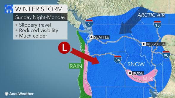
The same storm forecast to bring snow to the Southern California passes during Monday and Tuesday is also predicted to bring snow to the Seattle and Portland, Oregon, areas.
Much colder air will settle into the Northwest with the lowest temperatures of the winter so far likely next week.

