How long could a refilled Tulare Lake stick around? The answer lies in the Corcoran clay
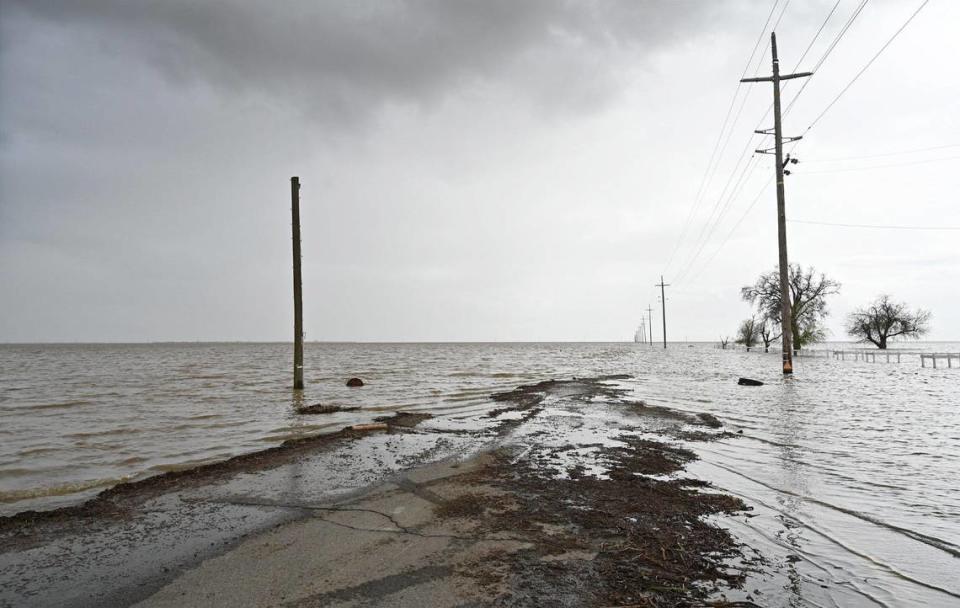
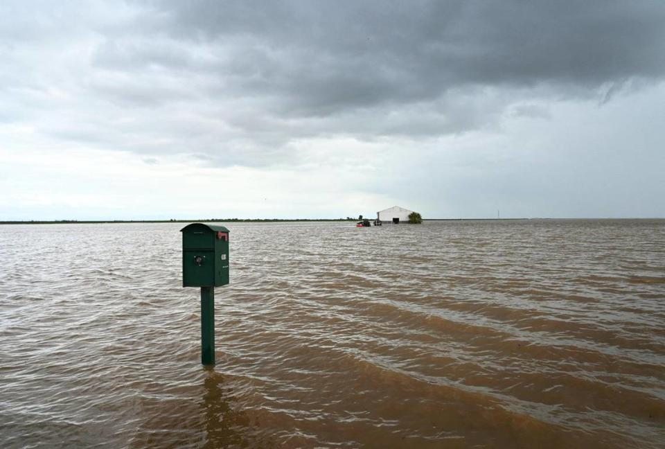
For modern-day residents of the southern San Joaquin Valley, the sight of floodwaters collecting in the former Tulare Lake basin over recent days is a jarring reminder of what happens when more rain falls than dams can contain, soil can absorb or farmers can utilize.
Several factors are conspiring to suggest that the fertile farmland of the old lake bed may remain submerged for as much as a year or longer: a record snowpack just waiting to melt with runoff flowing to the Valley floor this spring and summer; an ancient and impervious layer of soil known as the Corcoran clay that keeps water from draining effectively; and land subsidence from overpumping the underground water table, deepening the lake bed over the recent decades.
In the mid-1800s — before extensive canals were built to divert natural water flows from the Kings, Kaweah and Tule rivers and decades prior to the construction of foothill dams on those rivers — a 2007 study prepared for the U.S. Environmental Protection Agency reports that Tulare Lake was a more or less permanent feature of the Valley’s landscape, encompassing as much as 790 square miles in what is now Kings County.
While the old lake was large, reportedly the largest lake west of the Mississippi River, it was also shallow, about 37 feet deep in years such as 1853 and other high-water years.
The diversion of water from the rivers and their tributaries eventually dried Tulare Lake by 1899, but the lake has remained susceptible to periodic resurrection from floods during wet years of the 20th century and into the 21st century.
Which is another way of saying: This certainly isn’t the first time the old lake bed has flooded, and it won’t be the last. The big question is, how long will the farmland remain underwater before the lake dries up once again?
John T. Austin, a now-retired scientist with the National Park Service and author of “Floods and Droughts in the Tulare Lake Basin” — an extensive book exploring both the recent and ancient history of Tulare Lake — said that two years of floods in 1982 and 1983 resulted in a lake that didn’t fully disappear until 1985.
“There were good eyewitness accounts of being able to see the lake all the way from the Sierras,” Austin told The Fresno Bee this week. The drying-out process took about two years after the 1983 flood.
This year, “with the water coming down now, I’d guess most of it won’t be gone before next summer” in 2024, Austin added.
Tulare Lake flood will grow when Sierra Nevada snow melts
At Pine Flat Reservoir — the largest of the foothill lakes on the rivers feeding into the Tulare Lake basin — about 780,000 acre-feet of water was being held in check as of Friday. That’s about 78% of the lake’s capacity of 1 million acre-feet, and 152% of the average storage behind Pine Flat Dam for the date.
Friday’s storage figures at other dams in the southern Sierra Nevada watershed, as reported by the state Department of Water Resources, are:
Lake Kaweah, behind Terminus Dam on the Kaweah River east of Visalia: 167,218 acre-feet, 90% of the lake’s capacity of 185,000 acre-feet and almost 375% of the average storage for the date.
Lake Success, behind Schafer Dam on the Tule River east of Porterville: 67,104 acre-feet, 82% of the lake’s capacity of 82,300 acre-feet and more than 230% of the average storage for the date.
Lake Isabella, behind Isabella Dam on the Kern River northeast of Bakersfield: 360,237 acre-feet, 63% of the lake’s capacity of 568,000 acre-feet and almost 200% of the average storage for the date.
The U.S. Army Corps of Engineers, which operates the four dams, is striving to maintain a balance between minimizing the potential for downstream flooding while at the same time trying to release enough water to make room for future storms and the spring snowmelt.
What’s happening to Tulare Lake now, however, doesn’t yet include substantial runoff from the massive snowpack that has accumulated in the southern Sierra Nevada and the watersheds that feed the Kings, Kaweah and Tule rivers — a snowpack that currently contains almost three times as much water content as the benchmark April 1 average, according to the state Department of Water Resources.
If a significant early spring heat wave or warm rainstorms cause all that snow to melt quickly, the runoff would easily outpace the ability of dams on the feeder rivers to contain the water, creating the prospect of damaging floods downstream from the dams and pouring even more water into Tulare Lake.
And another very wet winter in the 2023-24 water year would add more water — and more time — to the drying-out period.
Corcoran clay slows water from seeping into aquifer
Compounding the lake’s staying power is the nature of the underlying soil, which includes a thick layer of impermeable clay called the Corcoran clay layer — a Pleistocene-era sediment laid down between 600,000 and 800,000 years ago under ancient Lake Corcoran that extended from modern-day Bakersfield to Stockton. The clay sediment under the former 250-mile-long lake underlies about 6,600 square miles on the west side of the San Joaquin Valley.
That clay layer, identified in a 1954 geological article as ranging between 50 and 120 feet thick and about 200 to 800 feet below the surface of the soil, is one factor that prevents much of the water that pools in Tulare Lake from draining into a deeper underground water table.
“Only about 4% of the water goes through the ground; an enormous amount just evaporates,” Austin told The Bee. In a typical water year, farms across the east and west sides of the southern San Joaquin Valley can use much of the winter runoff, and later spring and summer snowmelt, to irrigate the thousands of acres of crops in the region.
But this is not a typical water year. “All of this is coming down early in the growing season, and some of these farmers may not even be able to get in and plant their crops,” Austin said. “It’s going to be a hard time getting rid of it before next summer.”
Austin added that the large-scale farming companies in the lake basin have developed strategies over the decades to use levees to divide their land into different blocks to which water can be moved to isolate the flooding. But when the volumes are too much, those options have limited effect.
In the large 1982-83 flood years, “farmers did move some water back to the east to the Friant-Kern Canal” where it could flow south toward the Bakersfield area, enabling them to resume farming some blocks of acreage earlier, and using as much of the accumulated flood water as they could on their crops.
Also in very wet years, some water that would ordinarily flow into Tulare Lake from the Kings River’s south fork can be diverted into the north fork of the Kings and sent north toward the San Joaquin River near Mendota and Firebaugh through the Fresno Slough and James Bypass. But flooding concerns for the San Joaquin River are likely to limit that water-shifting capacity.
Subsidence due to pumping water during dry years may increase flood impact
Another potential complication to the flooding of Tulare Lake is the issue of subsidence — a sinking of the land as a result of pumping water out of the ground. Groundwater overdrafts have contributed to subsidence throughout the Valley, but in the Tulare Lake Basin, a reduction in the elevation of the land may result in an even larger area to be affected by flooding.
The state Department of Water Resources, in a March 2 letter to consultants on a groundwater sustainability plan for the lake basin, reported that subsidence over a eight-year period from 2015 through 2022 amounted to a drop in the ground elevation of more than 4.6 feet in one monitoring site, and a drop of almost 5.2 feet in another location.
“For the past decade, extensive groundwater withdrawal has lowered portions of the Tulare Basin, including areas both in and around the historic lake,” wrote Jeffrey Mount, a senior fellow with the Public Policy Institute of California’s Water Policy Center, in a blog post this month.
As a result, “flooding may affect a potentially wider area that’s now lower and within reach of flood waters,” Mount added. “Second, even though infrastructure that’s used to move water around in the Tulare Basin is critical to managing flood waters, subsidence has altered the slope of many irrigation canals, reducing their capacity to move water.”