Storm updates: Jefferson County under state of emergency, Gov. Beshear set to visit
- Oops!Something went wrong.Please try again later.
The National Weather Service in Louisville has issued a tornado watch for the Louisville metro area until 10 p.m. Tuesday.
NWS meteorologist Brian Neudorff said the biggest concerns are tornadoes, wind gusts of up to 80 mph, and baseball-size hail.
Several damage reports across central and eastern Kentucky and two confirmed tornadoes were the results of the first round of weather Tuesday morning and stronger storms could be possible beginning in the early evening, according to the latest forecast from the weather service.
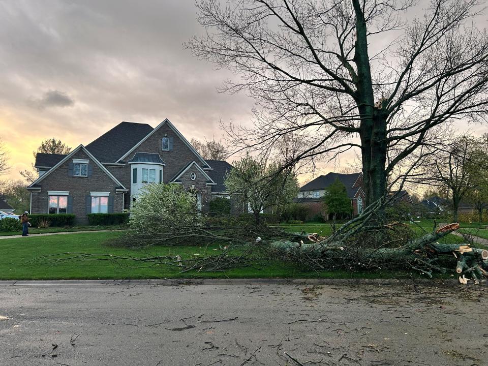
9:45 p.m.: Cleanup underway in Prospect
The storms Tuesday night left a trail in Louisville Prospect.
Residents and others in the community were out at sunset clearing yards and streets. They moved quickly, too — the exit lane to the Sutherland subdivision was blocked by a fallen tree in the aftermath of the chaos but had been cleared by 8:30 p.m.
Shaminda Hubert and his wife Irangi were out after 7:30 p.m. clearing their yard. They lost three trees, including a cherry tree that had stood for generations.
The couple headed to their basement a little after 6 p.m., they said, with their dogs Luna and Brownie. They watched updates from WAVE’s weather crew on their TV but lost power as the storm rolled through. They emerged 15 minutes later to a yard and street covered with fallen tree limbs.
“It was like a freight train going through,” Shaminda said.
Ann Ainsworth’s home didn’t see any damage, but she was out after the storm helping with clean-up efforts. She and her husband, who was out Tuesday night with a chainsaw helping other neighbors clear their yards, took cover in their basement when they heard the storm approaching their street — neither family knew of anyone who had been injured, but the storms had a visible impact.
“They said it was on Bass Road, which is literally on the edge of our neighborhood, so we were like, ‘OK, basement, basement, basement — to the basement,” she said. “You could just hear it.”
8:30 p.m.: Greenberg declares state of emergency for Jefferson County; Governor Andy Beshear to visit area
Jefferson County is under a state of emergency as a result of severe weather, Louisville Mayor Craig Greenberg announced shortly after a press conference at Jefferson County Fire Service's Anchorage Middletown Fire & EMS Station late Tuesday evening.
The bulk of storm damage is in the Prospect, Kentucky, area, according to Greenberg. Governor Andy Beshear is expected to visit the area Wednesday to survey the storm damage.
Between 5:15 and 6:30 p.m., Louisville Metro's 911 call center received hundreds of calls, most of which reported outdoor gas smells.
There have been no reports of injuries or deaths in the Louisville area, but there has been significant damage to homes, fences, trees and wires. Some of the felled trees are blocking roadways. City officials are working with Beshear's office to remedy the forestry issue.
The city is also working with LG&E to switch off power to lines that have been downed. Crews are out working on the effort right now, Greenberg said.
In other related news, the Louisville Division of Fire has deployed crew members to aid Henry County in relief efforts, Captain Donovan Sims announced. The Pleasure Ridge Park Fire Protection District and the Fern Creek Fire Department have also sent crew members to assist in the effort, which is centralized in New Castle, Kentucky.
8 p.m.: Images show damage in Prospect
The storm damage in eastern Louisville is no joke. Several neighborhood roads closed in the Sutherland and Hunting Creek neighborhoods, Prospect area. Updating coverage from @courierjournal: https://t.co/d3jMUhDB3K pic.twitter.com/uZyoz7D0gx
— Lucas Aulbach (@LucasAulbach) April 2, 2024
7:45 p.m.: Clark County issues aid to residents in need of shelter from severe storms
Clark County, Indiana residents in need of shelter or assistance from the severe weather can go to the Family Assistance Center at Jeffersonville Fire Station 44, 5311 E SR-62, Clark County Emergency Management Agency announced via Facebook. They can also contact 812-246-6996.
Clark County is still under a tornado watch until 10 p.m.
7 p.m.: Oldham EMS in 'search and rescue' phase as reports of nearly a dozen damaged homes
Oldham County Emergency Management is in "search and rescue phase" as the agency has reports of upwards of 10 homes in the area being damaged by the storms, according to Emergency Management Director Zack Wilt. Some of these homes have severe roof damage with at least one home collapsed in Prospect.
WHAS11 News reported two people in Prospect being rescued from the collapsed home, citing the South Oldham Fire Department. The Courier Journal has reached out to the South Oldham Fire Department to confirm this report.
There have been no reports of any injuries or deaths.
6:30 p.m.: Damage reports roll in from severe weather around Louisville; no injuries reported
The National Weather Service in Louisville has issued a new Severe Thunderstorm Warning for Jefferson, Oldham, Henry, Shelby and Trimble counties until 7 p.m.
Multiple homes have been reportedly damaged in the Prospect area, according to Jessica Wethington, assistant director of public information for Louisville Metro Emergency Services.
Crews are on the scene right now to assess the homes' damage. Other damage reports include downed wires and felled trees as well as two roofs blown off in the area.
Wethington said no injuries have been reported at this time.
The Indiana State Police reported two tractor trailers were flipped over on westbound Interstate 265 near the Lewis and Clark Bridge, resulting in minor injuries.
6:20 p.m.: More than 12,000 LG&E customers without power
More than 12,000 LG&E customers have lost power as a strong storm system that has produced several tornadoes moved through the region early Tuesday evening.
According to the LG&E outage map, 2,563 customers in Jefferson County and 2,913 customers in Oldham County have lost electricity.
Crews are working as quickly as possible to restore power, according to the LG&E website.
6 p.m.: Tornado Warning canceled for Jefferson County; new warning issued for Henry County
The National Weather Service has cancelled the tornado warning in Jefferson County, but the advisory continues for Oldham, Shelby and Henry counties.
A tornado has been confirmed near Coldstream moving east at 45 miles per hour. Coldstream is located about 15 miles from Louisville. Another storm capable of producing a tornado was also indicated near La Grange.
5:40 p.m.: Tornado warning issued for Jefferson County, 'extremely dangerous' tornado spotted in area
A tornado warning has been issued until 6 p.m. for Jefferson County in addition to other nearby counties of Oldham, Henry and Shelby.
A "large and extremely dangerous" tornado was located over Prospect, moving east at 45 miles per hour.
5:20 p.m.: Tornadoes reported in Southern Indiana, Jefferson County gets severe weather warning
A severe thunderstorm warning has been issued for for the Louisville metro area, including Jefferson County and Clark and Floyd counties in Indiana, until 5:45 p.m.
The National Weather Service in Louisville also reported that two tornadoes, one 10 miles south of Vernon, Indiana, and one eight miles north of Madison, Indiana, were seen on the ground and moving east at 60 miles per hour. Jefferson County, Indiana is currently under a tornado warning until 5:30 p.m.
Many felled trees and torn roof on a fire station has been reported in Crawford County, Indiana as part of ongoing reports of weather damage.
4 p.m.: EF-1 tornadoes confirmed in Nelson, Anderson counties; more local disaster declarations roll in
Damage has been reported across several Kentucky counties as another wave of severe weather is expected to impact the commonwealth late Tuesday afternoon and into the evening.
In a statement, Gov. Andy Beshear said EF-1 tornadoes were confirmed to have touched down in Anderson and Nelson counties during the first round of severe weather Tuesday morning.
“We have more severe weather on the way, and the most important thing we can do right now is make sure everyone has a plan to stay safe,” Beshear said. “We are thankful to those who are working to keep others informed – as well as our first responders and utility and transportation workers who are restoring power and clearing roadways.”
Beshear said damage has been reported in 19 Kentucky counties, including Jefferson County, and written disaster declarations have been received from Boyd and Greenup counties, along with the cities of Ashland and Catlettsburg in northeast Kentucky along the Ohio River. Verbal disaster declarations have also been received from Bourbon, Clark, Elliott, Jessamine and Kenton counties and the city of Villa Hill.
In a video message earlier Tuesday, Beshear said large portions of western Kentucky in the Jackson Purchase, which includes Ballard, Fulton, Graves and McCracken counties, among others, will be at the highest risk, though a large portion of the commonwealth could see damaging winds Tuesday night.
"This is the worst forecast that I have seen as governor, and that's saying something," he said.
More than 31,500 customers are estimated to be without power as of 3:50 p.m.
The entire Louisville metro area has also been placed under a Tornado Watch until 10 p.m.
2:36 p.m.: Straight-line wind confirmed in Spencer County, Kentucky; Bellarmine University cancels inperson classes
Straight-line wind damage was confirmed in far southeastern Spencer County, including winds of up to 70-75 mph that damaged an old barn, according to the National Weather Service of Louisville.
"Several sections of the barn were thrown 40 yards on top of a Chevy Silverado," according to the survey summary. "The owner of the property had just left to go inside his farmhouse next door by just a few minutes ... Debris was thrown across Eggen Road, all facing to the southeast."
Bellarmine University has also canceled in-person classes due to the increased weather risk, according to a post on X, formerly Twitter. Online classes will meet as scheduled
BU ALERT: Bellarmine CLOSED effective immediately due to severe weather. In-person classes are canceled; online classes meet as scheduled. https://t.co/7JXvMQFpwv
— Bellarmine University⚔️ (@bellarmineU) April 2, 2024
1:58 p.m.: Gov. Beshear declares state of emergency following storms
Gov. Andy Beshear declared a state of emergency Tuesday afternoon in response to the damage caused by storms that passed through the commonwealth in the morning, according to a release from his office.
Beshear said he has heard several reports of damages throughout the state and many residents are without power, but there has not been word of any fatalities so far.
“We need all Kentuckians to stay weather aware as we brace for more severe weather throughout the afternoon and evening,” he said.
Beshear said the commonwealth's anti-price gouging laws have been activated as residents prepare to clean up and emergency managers and other emergency personnel, including Kentucky State Police and the Kentucky Transportation Cabinet, have been deployed to affected areas to assist.
“We are thankful for all the first responders and transportation employees who are out there helping to clear roadways and keep Kentuckians safe,” Beshear said.
1:31 p.m.: UofL shuts down ahead of afternoon severe weather
The University of Louisville has canceled afternoon classes Tuesday due to the incoming weather.
University officials advised that clinic patients should call ahead to get the status of their appointments.
1:09 p.m.: Executive Branch offices closed due to weather
Gov. Andy Beshear has ordered all the Executive Branch state office buildings to be closed ahead of a second round of severe weather expected to impact the commonwealth Tuesday afternoon.
Executive Branch agencies will continue providing services and employees whose work is mandatory will remain on duty, according to a post from the Kentucky Personnel Cabinet on X, formerly Twitter.
Due to inclement weather, Governor Beshear is closing all Executive Branch state office buildings Tuesday, April 2, beginning at 1:00PM EST. pic.twitter.com/YzJRGIU7uS
— KY Personnel Cabinet (@KYPersonnel) April 2, 2024
1:05 p.m.: Snow showers in Louisville forecast for Wednesday and Thursday following storm
Rain and snow showers are in the forecast for Wednesday and Thursday, according to the latest forecast from the National Weather Service in Louisville.
According to the weather service, snow showers are possible Wednesday evening and Thursday before 11 a.m. Here is the complete forecast:
Wednesday: Showers likely, then showers and possibly a thunderstorm after 2 p.m. High near 50 degrees. West wind 10 to 20 mph, with gusts as high as 30 mph. Chance of precipitation is 90%. New rainfall amounts of less than a tenth of an inch, except higher amounts possible in thunderstorms.
Wednesday Night: Rain showers before 2 a.m., then a chance of rain and snow showers. Low around 36 degrees. West wind 14 to 18 mph, with gusts as high as 26 mph. Chance of precipitation is 80%. Little or no snow accumulation expected.
Thursday: A chance of rain and snow showers before 11 a.m., then a chance of rain showers. Mostly cloudy, with a high near 47 degrees. West wind 11 to 16 mph, with gusts as high as 25 mph. Chance of precipitation is 50%. Little or no snow accumulation expected.
12:34 p.m.: EF-1 tornado preliminarily confirmed in Nelson County
The National Weather Service in Louisville has preliminarily determined that an EF-1 tornado with winds of 90 mph touched down in outside of the town of Chaplin in Nelson County on Tuesday.
There have not yet been official reports of the extent of the damage in the area.
Gov. Andy Beshear urged residents to be cautious due to downed trees and powerlines throughout the commonwealth.
We've had damaging winds across the commonwealth and multiple tornadoes reported but not confirmed at this time. Be aware that some roads are closed due to downed trees and power lines. Crews are working to clear them now. 1/2
— Governor Andy Beshear (@GovAndyBeshear) April 2, 2024
12:25 p.m.: Some Southern Indiana school districts dismiss early due to storms; UK cancels afternoon classes
Several districts in Southern Indiana have opted for early dismissal for students ahead of a second round of severe weather expected to impact the region Tuesday afternoon.
The following districts will dismiss early:
Borden Henryville School Corp.: Dismissing two hours early
Crawford County School: Dismissing at 1 p.m.
East Washington County Schools: Dismissing at 1 p.m.
Greater Clark County Schools: Dismissing at 12:30 p.m.
Jennings County Schools: Dismissing at 1:05 p.m.
North Harrison Community Schools: Dismissing at 12 p.m.
Scott County Schools - Districts 1 and 2: Dismissing at 1 p.m.
Springs Valley Community Schools: Dismissing at 1 p.m.
West Washington County Schools: Dismissing at 1 p.m.
Beth Haven Daycare: Dismissing at 12 p.m.
The Louisville Zoo also announced that its special Wild Lights event will be canceled Tuesday.
The University of Kentucky has also announced that all in-person classes after 12:30 p.m. have been canceled. All staff except those on designated Plan B are also dismissed at the same time.
URGENT: In-person classes at or after 12:30 are canceled. On-campus employees dismissed at 12:30 except designated Plan B. For UKHC info go to https://t.co/Nc5MSKUsNT
— University of Kentucky (@universityofky) April 2, 2024
9:17 a.m. Severe Thunderstorm Warning for Lexington and other parts of Kentucky
The National Weather Service of Louisville issued a Severe Thunderstorm Warning until 10:15 a.m. for Lexington, Richmond and Nicholasville.
Severe Thunderstorm Warning including Lexington KY, Richmond KY and Nicholasville KY until 10:15 AM EDT pic.twitter.com/7TGarffR7o
— NWS Louisville (@NWSLouisville) April 2, 2024
8:57 a.m. More than 2,000 people without electricity
An estimated 2,286 people are without electricity service due to the severe weather passing through parts of Kentucky, according to the LG&E power outage map.
8:30 a.m. Severe Thunderstorm Warnings issued for parts of Southern Indiana, Kentucky
Strong thunderstorms will impact parts of Floyd, Harrison and Jefferson counties in Indiana and parts of Oldham, Jefferson, Bullitt, Hardin, Larue, Nelson and Meade counties in Kentucky.
Strong winds of up to 60 mph and hail are possible with the storm, the weather service said.
7:50 a.m.: Tornado warning issued for Crawford, Harrison and Perry counties in Indiana, Meade County in Kentucky
The National Weather Service in Louisville has extended a tornado warning until 8:15 a.m. for several Indiana counties as a storm that has produced at least one tornado moves through the area near Santa Claus, Indiana, and approaches the cities of Deuchars, Leavenworth and New Amsterdam.
According to the weather service, the storm is currently moving through the region at roughly 60 mph and is approaching the downtown Louisville area.
Louisville weather radar
More: Jeff Brohm's offense delivered for Louisville football in Year 1. Cards coach expects more
This article originally appeared on Louisville Courier Journal: Live Louisville weather: Several reports of damage around Louisville

