Live updates: Deadly severe storms, tornadoes tear through areas from Mississippi to Tennessee
The first full week of November is kicking off with severe thunderstorms across the Tennessee and lower Mississippi River valleys, including several confirmed tornadoes.
"The strongest thunderstorms will have the potential to cause widespread wind damage, tornadoes, hail and heavy downpours," AccuWeather Storm Warning Meteorologist Richard Schraeger.
The highest risk of tornadoes will be in a corridor stretching across northern Mississippi, northwestern Alabama and central Tennessee. This includes Greenville and Tupelo, Mississippi, and Memphis, Jackson and Nashville, Tennessee.
Tornado damage from severe storms from Louisiana to Kentucky
AP Photo/Garret Fischer


First, at vero eos et accusamus et iusto odio dignissimos ducimus qui blanditiis praesentium et accusamus et iusto odio dignissimos ducimus qui voluptatum.


(Image via Natchitoches Parish Sheriff's Office)
Confirmed tornado spotted in Natchitoches, Louisiana.
(Image via Natchitoches Parish Sheriff's Office)
Confirmed tornado spotted in Natchitoches, Louisiana.
(Image via Twitter/MPGodfrey60)
Confirmed tornado spotted in Natchitoches, Louisiana.
(Image via Natchitoches Parish Sheriff's Office)
Home damage from a confirmed tornado spotted in Natchitoches, Louisiana.
(Image via Natchitoches Parish Sheriff's Office)
Home damage from a confirmed tornado spotted in Natchitoches, Louisiana.
These storms will bring an added danger after nightfall as they will be difficult to see as they approach.
Download the free AccuWeather app to know exactly when rain and storms will arrive and to be alerted when severe weather approaches.

2:20 a.m. CST Tuesday:
Local media has reported widespread damage across Tennessee in the wake of tonight's storms, including heavy damage and a destroyed press box at Loretto High School baseball field and trees and powerlines down across Franklin County.
One death and several injuries have been confirmed in Christiana, Tennessee. The fatality occurred when strong winds caused a house to collapse. A mobile home is reportedly on its side and power lines are down all across back roads in the area, according to local media.
Students at Tennessee Tech University in Cookeville were ushered to the bottom floor of their dormitories as storms rolled through around 1:00 a.m. CST.
Emergency crews in Tupelo, Mississippi have begun assessing damage following a potentially tornadic storm that moved through earlier tonight. Tupelo Communications Director Leesha Faulkner says there was a gas leak in a residential area of the city and power outages have been reported.
Everyone from Altamont to Coalmont along HWY 56 should be sheltering now! Radar confirmed tornado continues northeast.
— NWS Nashville (@NWSNashville) November 6, 2018
The tornado watch has been extended eastward and now includes much of eastern Tennessee, northern Georgia and far western portions of North Carolina. As this line of storms marches eastward overnight, tornadoes and damaging winds will continue to be a threat.
1:30 a.m. CST Tuesday:
In Murfreesboro, Tennessee, students at Middle Tennessee State University awoke to tornado sirens and cell phone notifications around midnight as a tornado-warned storm moved overhead. So far no damage has been reported at the university.
MTSU ALERT: TORNADO WARNING ISSUED for MTSU Campus and TN Miller Coliseum areas. Take shelter immediately. Stay in your buildings as secured as possible.
— MTSU (@MTSUNews) November 6, 2018
Emergency managers reported a collapsed house in the wake of a tornado-warned storm that moved through Christiana, Tennessee around 12:20 a.m. CST.
Similar damage is possible with this storm as it continues to plow through central Tennessee over the next few hours.
Crews responding to structure collapse on 8085 Midland Road, a home possibly hit by Tornado on 2250 Rock Springs Midland Road and a structure fire on Barley Rd in Christiana. More details as they come in
— Rutherford County Fire Rescue (@RCFireRescue) November 6, 2018
12:35 a.m. CST Tuesday:
A series of tornado warnings are currently in effect from central Mississippi through central Tennessee. The National Weather Service has confirmed that a storm south of Nashville has produced a "large and extremely dangerous tornado" that is currently approaching Woodbury and Auburntown, Tennesee.
If you are under a tornado warning, take shelter immediately.
In the wake of these storms, reports of downed trees, powerlines and large branches are plentiful along with collapsed roofs and scattered cars, suggesting widespread damage.
Wind gusts around 40 mph have been reported at area airports as the storms passed through, though local damage reports will likely find that much higher gusts are occurring.
Anyone in an area under a tornado watch tonight should keep a weather radio or charged cell phone nearby with weather alerts enabled, and head to a storm shelter or other safe place at the first sign of threatening weather.
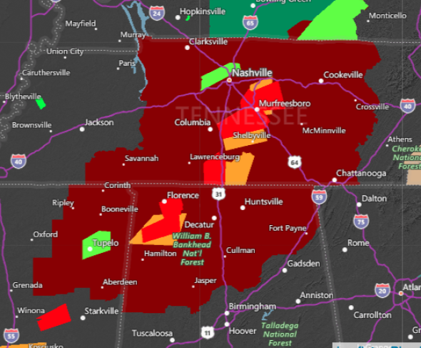
Tornado Watch (dark red), tornado warnings (bright red), severe thunderstorms warnings (orange) and flash flood warnings (bright green) in effect across the southern U.S. around 1:00 a.m. CST on Nov. 6, 2018.
9:00 p.m. CST Monday:
There are reports of a possible tornado near Burgess in western Lafayette County, Mississippi, just north of Oxford, Mississippi.
Tornado Warning continues for Batesville MS, Sardis MS, Courtland MS until 9:15 PM CST pic.twitter.com/zaPb2ntT4r
— NWS Tornado (@NWStornado) November 6, 2018
8:05 p.m. CST Monday:
Tornado warnings have been issued in northwestern Mississippi for very strong rotation over Marks, Mississippi and Lambert, Mississippi. The rotation is moving rapidly northeast toward the Sardis, Mississsippi area.
TORNADO WARNING in northwestern MS for very strong rotation over the Marks and Lambert, MS area as of 8:05 pm moving rapidly northeast toward the Sardis area next @breakingweather @accuweather #mswx pic.twitter.com/R44wofXPEq
— Reed Timmer (@ReedTimmerAccu) November 6, 2018
6:22 p.m. CST Monday:
Roads in some areas will begin to flood as storms release heavy downpours. Chrystal Hill Road in Hill Township, Arkansas is flooded.
Do NOT take Chrystal Hill Rd as a shortcut to Maumelle. Please ignore my sounds of panic. #arwx #flashflood pic.twitter.com/UeMMsGVqMF
— em dash (@EmilyEdmisten) November 5, 2018
5:40 p.m. CST Monday:
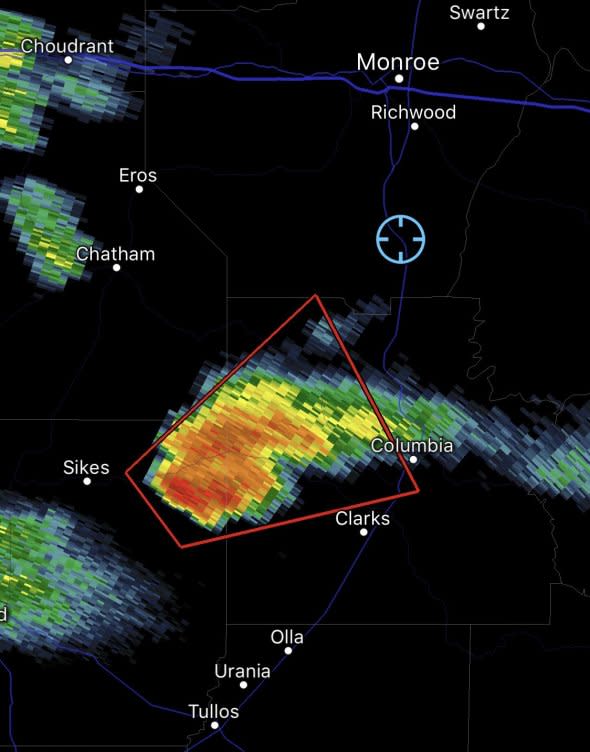
There is an area of concern for a potential tornado west of Columbia, Louisiana as of 5:40 p.m. CST.
4:52 p.m. CST Monday:
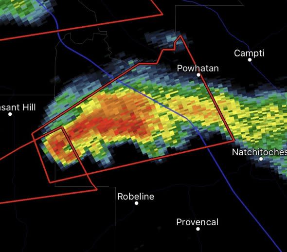
A dangerous tornado producing a supercell is approaching I-49 southwest of Powhatan, Louisianna, as of 4:52 p.m. CST.
4:48 p.m. CST Monday:
Photos and video were captured of the tornado near Natchitoches, Louisiana.
@KTBS Video of tornado by Natchez and Natchitoches. pic.twitter.com/P2gB9LdpQX
— Michael Godfrey (@MPGodfrey60) November 5, 2018
4:15 p.m. CST Monday:
A tornado has been confirmed by law enforcement near Natchitoches, Louisiana, and is tracking toward Saint Maurice. This storm may also bring flooding downpours and small hail.
3:51 p.m. CST Monday:
Severe thunderstorms are beginning to develop across the southeastern United States and will become more widespread in the coming hours.
The first severe storm of the afternoon has developed and is capable of producing a tornado near Zwolle, Louisiana.
Tornado Warning including Zwolle LA, Noble LA until 4:15 PM CST pic.twitter.com/mO4qG7QnjK
— NWS Shreveport (@NWSShreveport) November 5, 2018
3 p.m. CST Monday:
Severe thunderstorms are anticipated from Louisiana to Kentucky on Monday afternoon into Monday night with the greatest tornado threat focusing on northern Mississippi, northwestern Alabama and central Tennessee.
Storms will also be capable of bringing damaging winds, frequent lightning and flooding downpours.
11/5 11:10 am CST: Severe storms capable of damaging winds and tornadoes are likely this evening and overnight across the ArkLaMiss region and TN Valley. The best risk for tornadoes (a couple strong) will be across parts of nrn MS, nwrn AL, and wrn/middle TN. #mswx #alwx #tnwx pic.twitter.com/vIbW78z2XD
— NWS SPC (@NWSSPC) November 5, 2018

