Hurricane Ian Live Updates: Clay, St. Johns counties order evacuations, Jacksonville declares state of emergency
The Florida Times-Union has made this article free of charge for all readers in the interest of public safety. Please consider supporting local journalism with a digital subscription.
Quick Northeast Florida Hurricane Ian links:
Hurricane Ian: See the latest forecast, tracking map
High school football: Florida games postponed, canceled due to Hurricane Ian
Hurricane Ian: Duval, Jacksonville area closings and cancellations
Hurricane evacuation zones: Evacuation information for Duval, Clay, Nassau and St. Johns counties.
Read updates for Wednesday, Sept 28, here.
7 p.m. | Duval County Public Schools changes course, cancels classes Wednesday
After previously announcing plans to release students early on Wednesday, the Duval County school district said Tuesday evening that classes would be canceled. The district had already announced closures for Thursday and Friday.
In a statement on its website, the school district said the move comes in response to Mayor Lenny Curry warning in a tweet Tuesday afternoon that evacuations could become necessary as early as Wednesday for residents in evacuation zone A.
6:30 p.m. | Watches and warnings issued ahead of Hurricane Ian
A look at the latest watches and warnings issued in Northeast Florida:
If you can't see any local weather warnings here, you'll need to open this story in a web browser.
4:30 p.m. | Zone A residents should prepare for possible evacuation, mayor says
Hours after declaring a state of emergency, Mayor Lenny Curry advised residents in Duval County's Zone A on Tuesday afternoon to prepare for the possibility of evacuations Wednesday in advance of Hurricane Ian.
In a Twitter post, Curry said, "As Hurricane #Ian moves closer to the @CityofJax, we are watching closely to determine if evacuations in Zone A is the safest option for citizens. We will make this decision early Wednesday morning, but if you live in Zone A please be prepared for this possible scenario."
If you're not sure whether your home is in Zone A, check the county's evacuation zone map. Or you can use this tool to search by address.
Hurricane evacuation zones: Here's what you need to know in Duval County
3:30 p.m. | Clay County announces evacuation orders, to open shelters
Clay County officials have issued an evacuation order for residents in evacuation zones A, B, C, and the Black Creek North and South Prong zones, as well as those who live in mobile or manufactured homes.
The county is opening shelters at 3 p.m. Wednesday at Keystone Heights High School,
Orange Park High School, Clay High School and Wilkinson Elementary School.
In addition, a special needs shelter will be available at Lake Asbury Junior High School beginning at 8 a.m. Wednesday.
Hurricane evacuation zones: Here's what you need to know in Clay County
1:15 p.m. | St. Johns County orders evacuations
St. Johns County issued an evacuation order Tuesday to go into effect Wednesday at 6 a.m. The order covers residents in evacuation zones A and B, including the entire city of St. Augustine. The order also includes residents in evacuation zone F in the portion of the county south of County Road 214. About 180,000 residents are effected by the evacuation order.
Three shelters will be opened beginning Wednesday at noon. Those shelter locations are Pacetti Bay Middle School, South Woods Elementary School and Pedro Menendez High School.
See more information on St. Johns County emergency operations at sjcfl.us/hurricane.
Hurricane evacuation zones: Here's what you need to know in St. Johns County
1 p.m. | Jacksonville Mayor Lenny Curry declares state of emergency
Jacksonville Mayor Lenny Curry declared a state of emergency effective at noon Wednesday and activated the city's Emergency Operations Center in preparation for Hurricane Ian.
Government offices will close when the declaration goes into effect, and the city will open the Legends Center at 5 p.m. that evening as an emergency shelter. More will open if needed, Curry said at a news conference Tuesday afternoon.
"For those that do not know, a state of emergency declaration allows the city to more easily allocate dollars and resources to best protect lives and property," Curry said.
More: Jacksonville Mayor Lenny Curry declares state of emergency, announces closings
12:30 p.m. | Duval, St. Johns counties join list of districts canceling classes
Duval County Public Schools announced school closures Tuesday morning as the region prepares for Hurricane Ian.
All county public schools will be closed Thursday and Friday, and schools will release two and a half hours early Wednesday.
Extended day and after-school care will still operate Wednesday, but all extracurricular activities, including athletic practices and games, will be cancelled until Monday.
St. Johns County schools are closed Wednesday through Friday. Activities or athletic contests and extended day services will operate normally Tuesday.
12:00 p.m. | Where you can get sandbags and why you can't get them in Duval County
Sandbags are traditional bulwarks against water flooding into homes and businesses in Jacksonville and beyond during hurricane season.
But while many Northeast Florida county governments are supplying limited numbers of free sandbags and sand, as long as folks fill them themselves, Duval County does not.
The reason is that they don't mix with Jacksonville's drainage system, said Todd Smith, Emergency Preparedness Division chief.
You can see a list of where you can get sandbags in Northeast Florida.
Hurricane Ian: Here's where you can and can't get sandbags in Northeast Florida
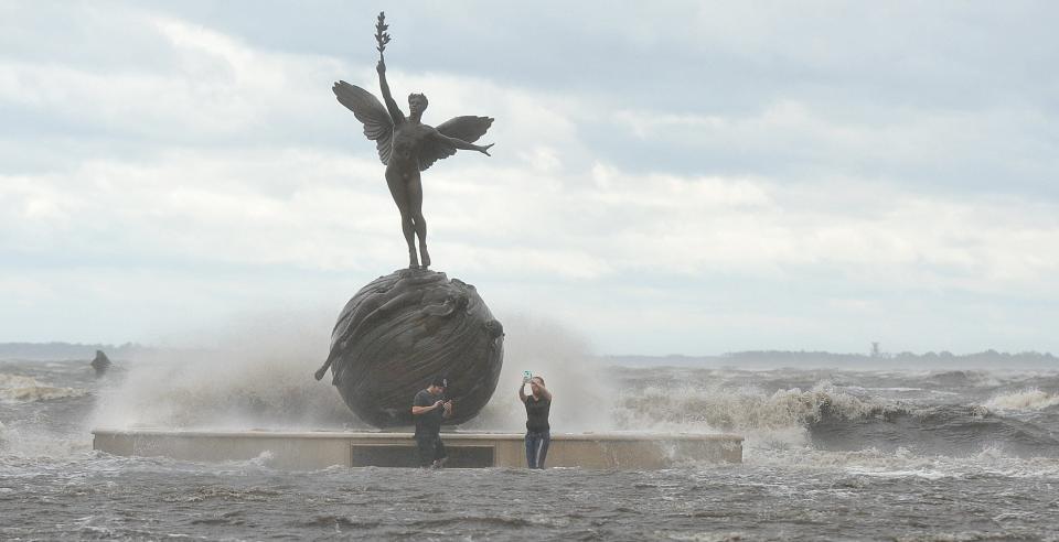
11:20 a.m. | Storm surge warning issues for Northeast Florida
A Storm Surge Warning has been issued for the east coast from Marineland to the mouth of St. Mary's River. That includes the St. Johns River, and the Dry Tortugas.
Jacksonville remains under a Tropical Storm Warning, which has now been extended on the east coast north to Altamaha Sound in Georgia and south to Boca Raton.
10:55 a.m. | Nassau, Clay schools announce closures
Nassau and Clay counties have joined the list of school districts closing in preparation for Hurricane Ian.
Nassau is closing on Thursday and Friday, while Clay is closing Wednesday through Friday.
See updated list: Duval, Jacksonville area closings and cancellations due to Hurricane Ian
10:00 a.m. |Florida State College at Jacksonville announces closures
Florida State College at Jacksonville will close Wednesday through Friday, including faculty and administrative offices. Classes are expected to resume Saturday.
9:00 a.m. | Watch the Gov. Ron DeSantis press conference live
6:30 a.m. | Will Hurricane Ian's punch echo Irma's Jacksonville impact?
It's impossible not to think of Hurricane Irma as we watch Ian's forecast.
After Irma left Jacksonville with historic-level flooding, journalists Nate Monroe and Christopher Hong investigated the role dredging of the St. Johns River played into what happened in 2017.
As the ocean creeps in: Century of dredging brought wealth, watery risks seen after Hurricane Irma
It's still not clear how close Ian will get to Northeast Florida, but Jacksonville University biologist Quinton White said the risk from flooding has been magnified by river dredging that deepened the shipping channel from the ocean to Jacksonville’s port.
That work, which was completed in May, cleared a path where ocean water will push against the river’s efforts to drain stormwater from the hurricane’s rains.
"If you flooded in Irma, now is the time to take precautions," National Weather Service meteorologist Angie Enyedi said. "... The more vulnerable areas again will be in open areas on the coast and really focused in the St. Johns River basin." — Steve Patterson
6:10 a.m. | Jags prepared for Ian
Jaguars coach Doug Pederson said the team hasn't changed its current practice or travel schedule but are prepared in case the track of Hurricane Ian changes for the worse. The current forecast calls for the area to experience tropical storm-force winds (39 mph or higher) and heavy rain beginning Wednesday night and into Friday.
"Those are things we have to take into consideration," Pederson said. "We've got people in-house that are monitoring that situation for and we'll be prepared either way if we stay and we'll be prepared if we have to move out of here for some reason."
The Jaguars had a road game the last time a hurricane threatened the area, Irma in 2017. They left for Houston, as usual, on a Saturday, but stayed in Houston an extra day until the storm cleared the area. — Garry Smits
6:00 a.m. | Duval Schools will provide update about classes by noon Tuesday
Jacksonville University announced it will close Wednesday through Friday. And Putnam County Public Schools said it was closing schools for the same time period.
Duval County School District officials said Monday they are monitoring the storm closely and will provide an update Tuesday about possible closures.
Some area high school sporting events were already postponed or canceled. — Clayton Freeman
5:00 a.m. | Jacksonville Mayor Lenny Curry asks residents to prepare
Jacksonville officials are monitoring Hurricane Ian — which is expected to bring high winds and lots of rain — and preparing for the worst.
Residents should also prepare, Mayor Lenny Curry said during a press conference Monday afternoon.
"The biggest threat to our area is excessive rainfall, moderate winds and tornados likely beginning late Wednesday, with the biggest impact happening Thursday," he said. "... While the weather is nice is when you want to check around your home, secure your loose furniture, clean gutters and yard waste and ensure everything is safe and secure."
See the latest storm forecast, tracking map provided by the National Hurricane Center.
Earlier Monday, the National Weather Service urged residents to prepare for a "significant storm"
"There's high confidence of tropical storm conditions through Thursday, really ramping up Wednesday night through Thursday," said weather service meteorologist Angie Enyedi. "Then the potential of the tropical storm force winds decreases as we get into and through the day Friday." — Dan Scanlan
This article originally appeared on Florida Times-Union: Hurricane Ian Jacksonville: What you need to know about impact, path

