NOAA predicts very active hurricane season, issues highest ever May forecast
Jeff Berardelli is WFLA’s Chief Meteorologist and Climate Specialist
TAMPA, Fla. (WFLA) — NOAA released its annual forecast for the 2024 hurricane season on Thursday and predicted a very active season is in store for the tropical Atlantic.
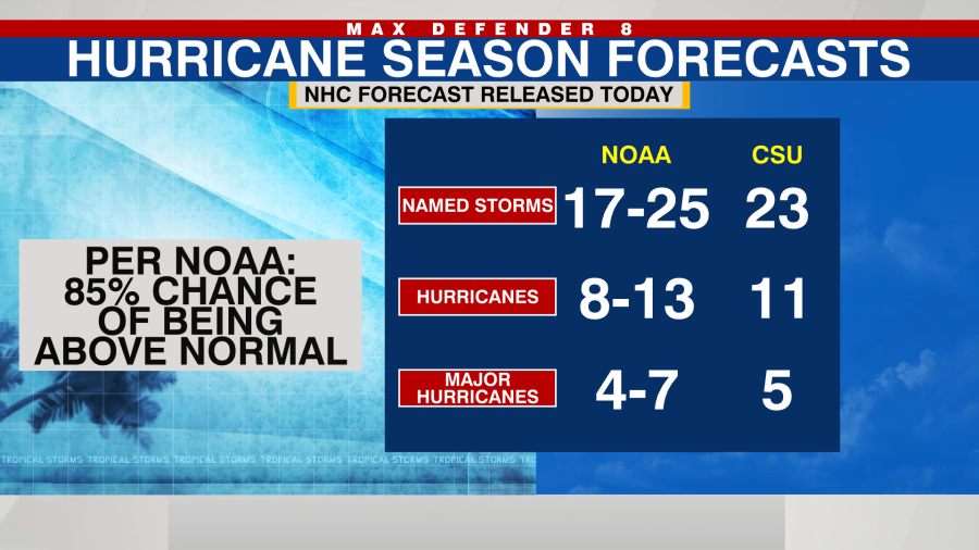
This season has an 85% chance of being above average. In an average season, there are 14 named storms, seven hurricanes and three majors.
Hurricane season starts soon. Here’s the exclusive Max Defender 8 early outlook
By the numbers, NOAA is forecasting between 17 and 25 named storms, eight to 13 hurricanes and four to seven major hurricanes (Category 3 and up) for 2024. It is the highest number of named storms, hurricanes and major hurricanes NOAA has ever issued for its May outlook.
While NOAA can’t say exactly when and where storms will strike, the historic record shows that in very active seasons like we are expecting in 2024, more storms tend to landfall in the US.
NOAA joins other agencies and universities raising alarms for an active season like Colorado State University calling for named 23 storms, the European’s (ECMWF) also calling for 23 storms and the UK Meteorology Service calling for 22.
NOAA’s reasoning for the big forecast is two-fold. Record hot water temperatures in the Tropical Atlantic Ocean and also the demise of El Niño – and likely formation of La Niña by summer – both natural climate cycles.
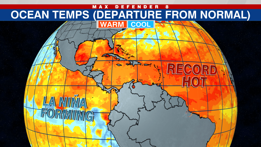
Right now sea surface temperatures are not only the record hottest overall in the Atlantic, but they are also record hot in each individual basin, including the central Tropical Atlantic, the Caribbean and the Gulf of Mexico, partly due to global warming.
This will likely result in storms that get stronger due to the excess high octane fuel available. That means we can expect more hurricanes and more major hurricanes than we saw last year – despite 2023 featuring numerous storms, but many weaker systems.
Record-shattering: Will uncharted ocean warmth point to active hurricane season?
The 2nd most important factor in our upcoming hurricane season is the rapid shift away from El Niño in the Pacific right now.
When El Niño fades and Pacific waters cool, the Atlantic becomes the more favorable basin for development. In addition a fading El Niño means that wind shear across the western side of the Atlantic basin should be below normal. For both of these reasons, it should be a busy hurricane season.
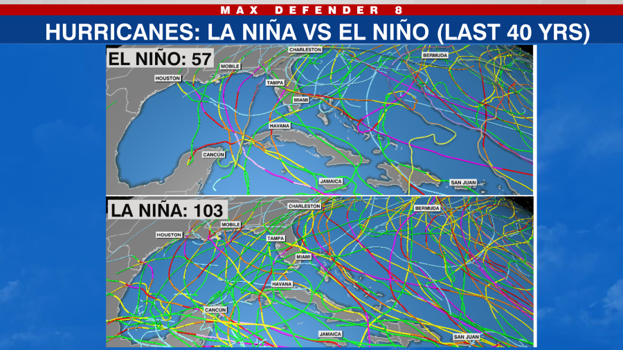
With the expectation of La Niña forming this summer, the below graphic shows that La Niña years tend to have many more hurricanes than El Niño – almost double – over the last 40 years. Also notice how during El Niño, which was present during last year’s hurricane season, there are no storms in the western Gulf. But in La Niña, the entire Gulf becomes more active.
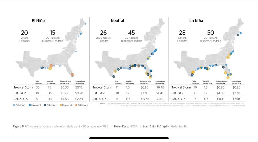
It’s not only overall number, it’s also the chance of landfalls close to home that goes up once El Niño fades. In the below graphic from Steve Bowen of Gallagher Re you can see Neutral (years with neither phase) and La Niña’s produce about double the number of US landfalls as compared to El Niño – and a lot more economic loses too.
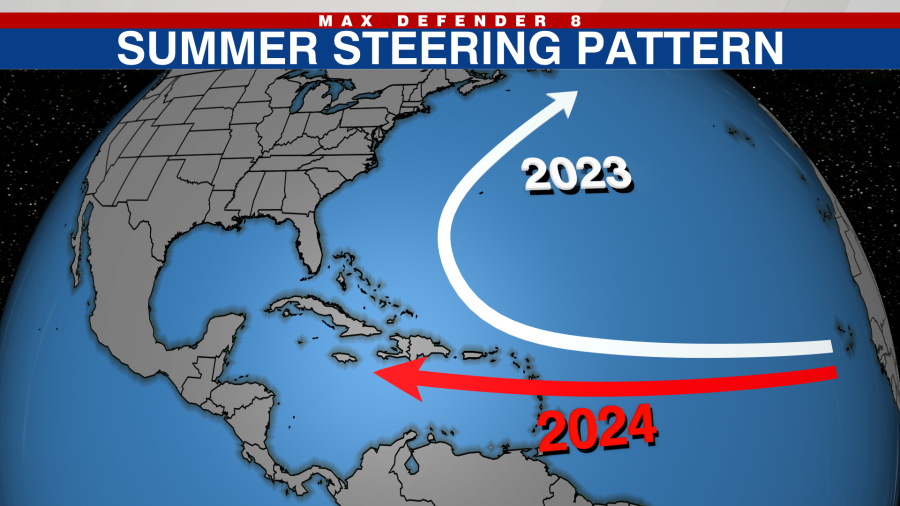
It’s worth mentioning that last hurricane season, the average storm track was near Bermuda, with most storms avoiding landfall in the U.S. That was well forecast by the spring computer models. This year, those same models show a storm track into the Caribbean and also near Florida. While it’s hard to say for certain, the models are probably onto something.
With that said, contrary to the active forecasts for the upcoming season, so far the Atlantic Basin has not seen a named storm. That is rare for the past 20 years in which we have seen 17 preseason storms form. Unfortunately, a quiet early season does not mean a quiet peak season. They are independent of each other.
From Alberto to William: Here’s the list of 2024 hurricane names
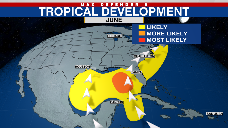
So when will the Atlantic heat up? As a favorable large scale climate pattern evolves in early June, the Atlantic should wake up; most likely somewhere in the Caribbean or near the Bahamas. If so, that would be nearby where storms tend to form in June – close to home – as we say.
Bottom line: You never know when a where a storm will strike ahead of the season. But with a hyperactive season forecast, it is better to be safe than sorry. Plan and prepare early.
Copyright 2024 Nexstar Media, Inc. All rights reserved. This material may not be published, broadcast, rewritten, or redistributed.
For the latest news, weather, sports, and streaming video, head to WFLA.

