Lasers and Lava: 3D Imaging Reveals Details of Volcanic Flows
As if volcanic eruptions weren't flashy enough on their own, volcanologists have added more flare to their research by using lasers to scan lava flows. The results not only produce compelling 3D images of lava flows, but also help hazard-mitigation teams prepare vulnerable communities for future flows, researchers say.
Lava flows are inherently tricky to study by foot because, unsurprisingly, they are dangerously hot when fresh — topping 1,000 degrees Fahrenheit (538 degrees Celsius) — and difficult to traverse when cool, becoming brittle and glasslike.
To overcome these challenges, volcanologists have traditionally turned to satellite imagery to study flows from above. But these aerial images often lack the resolution required to study the flows in close detail, particularly when clouds or trees block the view. [In Images: Hawaii's Mount Kilauea Erupts]
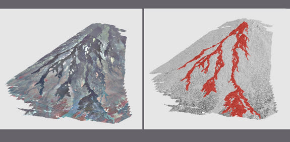
Now, researchers have honed laser scanning technology — also called lidar, a combination of the words "light" and "radar" — to produce much-higher-resolution aerial images that, among other things, allow scientists to digitally extract trees and other obstructive objects from their images.
Monitoring lava flows
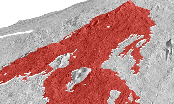
To collect the data, researchers equip airplanes with hundreds of thousands of lasers that scan the terrain at a perpendicular angle to the ground. The lengths of the laser beams indicate the height of the flow, and when multiplied hundreds of thousands of times, the scans can be compiled into 3D models that recreate the internal structure of the flow.
Geologists at the University of Oregon recently used this technology to create high-resolution 3D models of the remains of Hawaii's 1974 Kilauea and 1984 Mauna Loa eruptions.
"When you go down to the meter-scale resolution, all of a sudden, it is possible to start analyzing flows in a way that we have never been able to do before," said Kathy Cashman, a geologist at the University of Oregon who is involved in this research. "So it is opening up new ways of studying old flows and new opportunities for monitoring active flows."
Previous studies of the Mauna Loa and Kilauea eruptions focused almost exclusively on the main flow channels, but the team's new scans now expand the data set to include often-overlooked but significant side tributaries, said Hannah Dietterich, a graduate student working with Cashman at the University of Oregon.
Whole landscape view
The new data — which include up-close analyses of the shapes and surface textures of the lava tributaries — will add to the body of information that hazard-management groups use to predict the behavior of future flows, including the speed and direction of potentially damaging tributaries.
"No one has ever tried to look at where the lava is going within the flow in terms of places where it is thickening versus thinning, so this is a more complete view," Dietterich told LiveScience. "It's not a cross section, and it's not an estimate on top of an old topographic map, which is what you usually have."
Laser scanning technology is fairly expensive, but the resulting scans can be repurposed by researchers in fields of science entirely unrelated to volcanology, Cashman said. Geologists might choose to strip away forests to see lava flows, while forest biologists may choose to keep the trees and study their distribution for ecological assessments.
"The data are actually being widely used by anyone who is interested in topography and landscape," Cashman told LiveScience.
The team's work in Hawaii will be published in an American Geophysical Union Monograph on Hawaiian volcanoes in 2014.
Follow Laura Poppick on Twitter. Follow LiveScience on Twitter, Facebook and Google+. Original article on LiveScience.
Copyright 2013 LiveScience, a TechMediaNetwork company. All rights reserved. This material may not be published, broadcast, rewritten or redistributed.
