Large winter storm headed to Kansas. Here’s what is currently forecast for Wichita
Students at Wichita Public Schools didn’t get the snow day that many others area school districts did on Friday.
Will they get one Tuesday as another winter storm rolls in?
This storm will be much bigger, and more powerful with high winds that will cause blizzard-like conditions, though the forecast, as of Saturday evening, still isn’t clear about how hard Wichita will get hit.
“Wichita is going to see some snow on Tuesday, it just depends how much,” National Weather Service meteorologist Kevin Darmofal said around 5 p.m. Saturday. “The potential is there that this storm will be a lot more impactful, it is just a matter of where.”
NWS will have a better idea on Sunday of what areas will be impacted and how much.
For now, it looks likely that at least western Kansas and north-central Kansas and into Nebraska will have “very bad, near white out” and “if not blizzard, near blizzard conditions,” the Wichita meteorologist said.
Some areas could see as much as a foot of snow, he said.
School officials decide whether or not to cancel school. But, when asked if it will be likely for students to have a snow day on Tuesday, he said:
“Based on the current forecast, I can’t put a percentage on it. All I can say is it’s definitely possible Tuesday.”
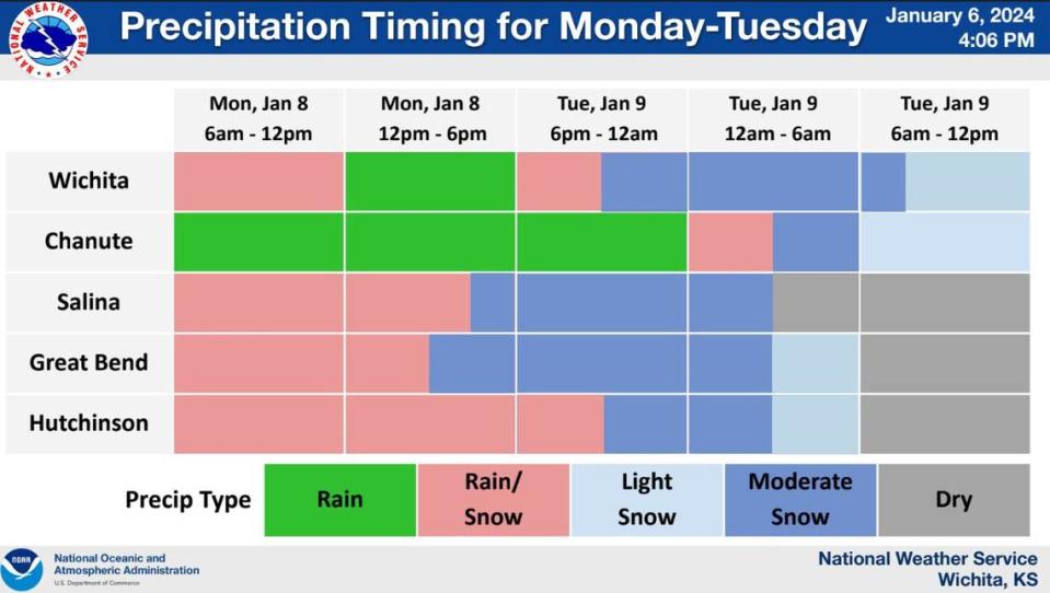
Rain and a mix of rain and snow are forecasted throughout the day Monday in Wichita. Moderate snow is expected late Monday night and early into Tuesday morning. The snow isn’t expected to stop until around noon.
Wind is one of the biggest concerns with this storm compared to Friday’s, which surpassed the Jan. 5 record of 2.6 inches set in 1929 with a total of 3.3 inches. Friday’s storm had sustained winds in the single digits.
Tuesday’s forecast has sustained winds between 20-30 mph and even higher gusts. The higher gusts are forecasted to be in the mid to high 40s between 7 a.m. and 1 p.m., according to the forecast Saturday evening.
People needing to travel should keep an eye on the weather and consider making other plans, he said.
“Travel could be very difficult to impossible over central Kansas,” the NWS in Wichita said in a winter-storm packet released around 4 p.m. Saturday, adding the “vigorous storm system will bring moderate and heavy snow with blowing and drifting.”
Additionally, colder temperatures next week should keep Tuesday’s snow on the ground longer.
The low temperature Tuesday night will be in the high teens; Thursday night has a low around 11 degrees and Friday night has a low around 2 degrees.
Wichita could also see more snow later into next week.

