La Niña is pushing El Niño out. What that means for El Paso's summer, winter in 2024
El Paso will likely experience another scorching summer and a warm winter with above-average temperatures.
There is about a 40% chance 2024 will be the hottest on record, despite moving out of El Niño, a warm phase, and into La Niña, a cooler phase, according to the National Weather Service in El Paso.
Additionally, there is a 99% chance this year will rank in the top five hottest years ever recorded.
El Paso might see its first 100-degree day of the year on Sunday, May 19. If it reaches this temperature, it will be only the second time in 30 years the city has hit 100 degrees on this date. The earliest recorded 100-degree day in the past three decades was on May 7, 2020, according to the National Weather Service.
What is La Niña?
Two extremes of reoccurring climate conditions — La Niña and El Niño — can influence weather globally.
The climate phenomenon known as La Niña — "little girl" in Spanish — is projected to form in the Pacific Ocean later this year.
Typically, jet streams created by La Niña are considerably unpredictable and can cause intense weather conditions. When storms and rainfall in the western Pacific push a weaker jet stream northward, it can lead to drought in the southern U.S. and cooler temperatures, heavy rains and flooding in the Pacific Northwest.
El Niño vs. La Niña:
The recurring climate pattern involving temperatures of waters in the central and eastern tropical Pacific Ocean is called the El Niño -Southern Oscillation, or ENSO. This oscillating warming and cooling pattern impacts rainfall in the tropics and has a strong influence in North America and other parts of the world.
In an El Niño year, ocean waters are warmer than usual, versus La Niña, when ocean water temperature is below average. There is also a neutral phase when temperatures are average.
The oscillation between El Niño and La Niña has been more frequent in the past couple of decades, Jason Laney, a meteorologist with the National Weather Service, said. Before, oscillations would happen every two, four, five, or even six years.
"We went almost three years in a row with La Niña with no change," Laney said. "Then suddenly, we went into El Niño, and we went into El Niño hard. It was the second or third strongest El Niño ever."
Climate models indicate La Niña's arrival by winter months, with a neutral phase coming in the next few weeks, Laney said.
In an El Niño phase, temperatures tend to be a bit warmer and wetter in the winter, while La Niña brings cooler and dryer conditions. However, no two are the same, and behaviors can vary — similar to their names, which translate to "little boy" and "little girl."
"For anyone who's raised a child, while they have certain temperaments and behavioral patterns, they can be unpredictable," Laney said. "The impact that they give us is always a little different."
When is the first day of summer?
This year, the first day of summer, also known as the summer solstice, is Thursday, June 20. The true solstice will arrive in the Northern Hemisphere at exactly 2:51 p.m. MST.
What's ahead for El Paso weather?
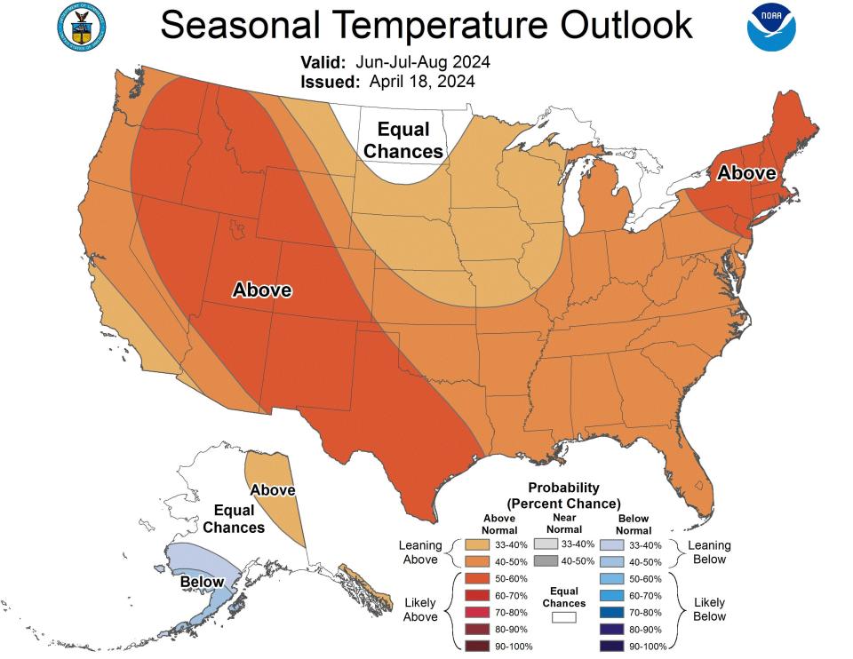
El Paso's summer —June, July, and August — will be hot and above normal. Precipitation will be below average, leading to even drier conditions and drought, Laney said.
"Last year was the record warmest year around the globe as well as in North America," Laney said. "There is a chance this summer is going to be hotter than that, despite La Niña, and that's scary because everyone said that was caused by El Niño."
The warmer temperatures and below-normal precipitation will continue into the fall months - September, October, and November — and in winter — December, January, and February—when temperatures could be above average despite the high probability of a La Niña phase.
While it's not guaranteed, Laney said there is still a chance for one or two snow events in El Paso during winter.
Warmer oceans bring more evaporation, placing more moisture in the atmosphere. The La Niña pattern could weaken the jet stream, opening the door to some big arctic plunges, he said.
"We could get lucky and combine the cold and extra moisture," Laney said. "Despite the general forecast that's warmer and dryer than normal, we could still have a very impactful winter storm or two."

What else is at play:
In the past year, the world's oceans have seen record warmth, Laney said. Since water covers so much more of the planet than land does, the fact the waters are warmer and don't cool off as quickly is leading to changes in overall climate patterns.
That's where Laney said climate change comes into play.
"Climate change is real," Laney said. "The data is pointing towards that and the impact that we've seen locally for climate change is hotter and dryer conditions, and that is what is driving these forecasts for us."
Since the ocean has such a significant influence on overall flow patterns of the atmosphere, especially in North America, rapid temperature changes will have some important impacts, Laney said. "There's no history for us to base the coming seasons on," Laney said. "In the past, we didn't have the climate change aspect, so we're entering a whole new other dimension. It's almost a wait and see attitude right now."
This article originally appeared on El Paso Times: La Niña is pushing El Niño out: El Paso faces hot summer, warm winter

