Which New Jersey towns will sink under water from sea level rise? Find out on this map
What would Lake Como's shoreline look like under three feet of water? What will the Manasquan Inlet Coast Guard station look like in the future with sea level rise?
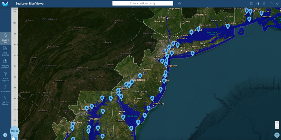
Maps from the National Oceanic and Atmosphere Administration show how sea level rise will inundate these locations and other Jersey Shore communities in decades to come, as rising oceans and sinking land contribute to rapidly rising water levels throughout the region.
The "Sea Level Rise Viewer" was prepared by NOAA's Office for Coastal Management, which provides information and resources focused on climate change's impacts to coastal and Great Lakes communities.
Around New Jersey, the viewer's interactive illustrations show how flooding would look under different sea level rise conditions at a variety of New Jersey locations, including the West Point Island Bridge in Lavallette, Double Creek Beach in Barnegat, Rumson's riverfront and the Keansburg pier.
Changing rules: How proposed flood rule changes could make it more expensive to build at the Shore
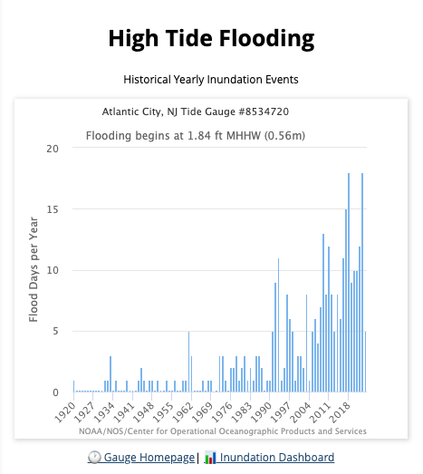
The map also shows that the number of flood days recorded at tidal gauges along the Jersey Shore — at Sandy Hook, Cape May and Atlantic City — have increased since 2000.
Sea level rise "is like a slow boil," said David Robinson, New Jersey's state climatologist. "It doesn't happen overnight. You don't see one foot rise in sea level in a decade. … But on geologic timescales, this is fast."
See how far it's already risen
Sea level has risen more than 18 inches along the New Jersey coastline since the early 1900s, due to a combination of the land sinking and sea levels rising, according to Rutgers University's Climate Change Resource Center. Since 2000, the pace of that increase is speeding up.
New Jersey's number of "flood days" are increasing across the region, according to Sea Level Rise Viewer data.
For instance, before 1992, Atlantic City had fewer than five flood days a year, according to NOAA's data. Between 2016 and 2023, Atlantic City had no fewer than six flood days each year, and six of those eight years recorded 10 or more flood days.
Looking to buy or rent in NJ? Sellers and landlords now required to disclose flooding risks
Multiple factors are causing the rise in water levels, Robinson said. Climate change is warming the ocean temperatures in the Atlantic ocean, and warmer water is less dense and takes up more volume than colder water, he said.
At the same time, more fresh water once held in glaciers and ice sheets is melting and contributing to the problem, Robinson said.
"The evidence from the Greenland ice sheet … the majority of northern hemisphere glaciers, and even portions of the Antarctic — clearly the West Antarctic ice sheets — all have been recognized to be losing volume," he said. "That volume of water is going into the oceans and that's raising sea level."
At the same time, New Jersey's land mass is slowly sinking in a process called subsidence, which is the result of centuries of glacier retreat across North America.
Pumping water out of the ground for human use also contributes to land sinking, Robinson said.
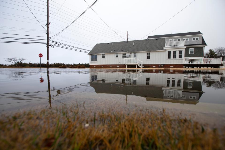
The town now floods even on sunny days. A Jersey Shore town is giving away money to help
What's next?
Rutgers University scientists say there is a 50% chance that sea level in New Jersey will be 0.8 feet higher in 2030 than it was in 2000. By 2050, the Rutgers scientists say there is a 50% chance that see level will be 1.4 feet higher than 2000 levels.
The rise is not expected to stop there, but to keep speeding up. By the end of the century, Rutgers scientists say there is a 50% chance that sea levels will be 3.3 feet higher than they were in 2000.
That much sea level rise will submerge many existing coastal roads, flood homes and businesses, and overwhelm valuable beachfronts in many New Jersey communities.
Alternative energy: Two new offshore wind developers coming to New Jersey waters as BPU gives green light
But it is when storm surges combine with sea level rise that the serious impacts will be keenly felt.
"Sea level has already risen over a foot and it continues to rise," Robinson said. "The pace of the increase is hastening. But still it's small, compared to the amplitude of a major storm … (but) it adds insult to injury."
The winter's El Niño, or warm onshore current in the Pacific ocean, is likely to transition into La Niña, or a cooling of the Pacific along the equator, the climatologist said. La Niña tends to lead to low pressure in the Atlantic ocean, which can lead to the formulation of hurricanes that could impact New Jersey, he said.
In addition, Atlantic ocean temperatures are far warmer in some regions this spring than typical, Robinson said.
"In March, the ocean temperatures in the subtropical Atlantic were about where they normally are the beginning of July," Robinson said.
Summer 2024 forecast: NJ will feel a hotter than usual summer but not so humid
Those warm ocean temperatures and La Niña conditions led the Colorado State University's Tropical Weather and Climate Research center to predict an intense and unusually active hurricane season in the Atlantic. The center described "well above-average" probability that a major hurricane would make landfall in the United States or Caribbean.
"It's a dangerous combination," Robinson said. "You throw that in with a rising sea … then it's a matter of timing."
See if you're in danger
To view the map, visit coast.noaa.gov/digitalcoast/tools/slr.html.
Amanda Oglesby is an Ocean County native who covers education and the environment. She has worked for the Press for more than 15 years. Reach her at @OglesbyAPP, aoglesby@gannettnj.com or 732-557-5701.
This article originally appeared on Asbury Park Press: Which NJ communities will be under water? NOAA map shows flood risk

