Hurricane Ophelia reaches Category 2 intensity, to make rare run at Ireland and UK

The 2017 hurricane season appears likely to make its mark on both sides of the Atlantic Ocean, as Category 2 Hurricane Ophelia takes aim at ... wait for it ... Ireland and the UK.
The storm, which had sustained winds of 100 miles per hour as of 5 p.m. ET, is a rarity for being so intense, and so far to the north and east in the Atlantic. In fact, it's the most intense hurricane ever observed so far east during the month of October, according to meteorologist Philip Klotzbach of Colorado State University.
SEE ALSO: How California's firestorm spread so mind-bogglingly fast: From 'Diablo' winds to climate trends
Typically, hurricanes develop well to the south of Ophelia's position, and get swept westward with the trade winds just north of the equator. During October, when ocean temperatures begin to drop and upper level winds increase the further north one goes in the North Atlantic, storms tend to form in the Gulf of Mexico or the Caribbean.
#Ophelia now has 100 mph winds - the strongest an Atlantic hurricane has been this far east (35.5°W) this late in calendar year on record. pic.twitter.com/6NPJvp2jCP
— Philip Klotzbach (@philklotzbach) October 12, 2017
In other words, Ophelia is an outlier.
This storm will get picked up by a different river of air: the midlatitude jet stream, which blows from west to east across the Northern Hemisphere. The National Hurricane Center expects the storm to meander slowly through the next few days, before encountering stronger upper level winds that will start drawing it eastward, and then to the north.
Sometime on Monday, Hurricane Ophelia is likely to become an ex-hurricane, by transitioning into a storm that feeds off the differences between air masses, known as a "baroclinic system," rather than a tropical cyclone that derives its energy from the heat and moisture flux off the ocean.
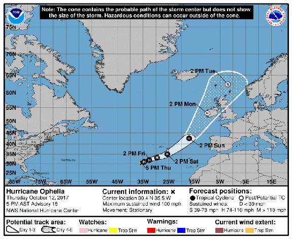
Image: noaa/nhc.
This transformation will not weaken the storm's winds much, though, so Ireland and the U.K. are preparing for a potentially strong storm to start the week, with some areas likely to see hurricane-force winds from this system. Hurricanes that undergo transitions from tropical to extratropical systems tend to feature greatly expanded wind fields, compared to the tight core of winds near the center, or eye, of a hurricane.
Computer model projections disagree on exactly how close the storm — in whatever form it is at that time — will pass to the UK and Ireland on Monday, but are in general agreement on its direction and evolution.

Image: weatherbell
Here's how the Hurricane Center summarized the uncertainty involved in the forecast, and what it means for Great Britain and Ireland:
Computer model projections show what is now Hurricane Ophelia approaching Great Britain and Ireland as a hurricane-force low pressure area by late in the weekend and early next week. Such a storm would pose multiple hazards, including strong winds, high waves, and heavy rain.
WATCH: A police officer recorded this dash footage as he drove through the California wildfire


