Hurricane Matthew: Potential disaster looms in Haiti, eastern Cuba and Bahamas

UPDATE: Oct. 4, 2016, 8:05 a.m. EDT Hurricane Matthew made landfall at 7 a.m. EDT on Tuesday morning near Les Anglais, Haiti, according to the National Hurricane Center. It crossed the coast packing maximum sustained winds of 145 miles per hour, with an extremely low atmospheric pressure reading of 934 millibars, indicating the fierce intensity of the storm. Hurricane Matthew will continue to batter Haiti with torrential rain, extremely strong winds and storm surge flooding throughout Monday before moving on to Cuba and the Bahamas. Mashable will have a new story on Hurricane Matthew later this morning.
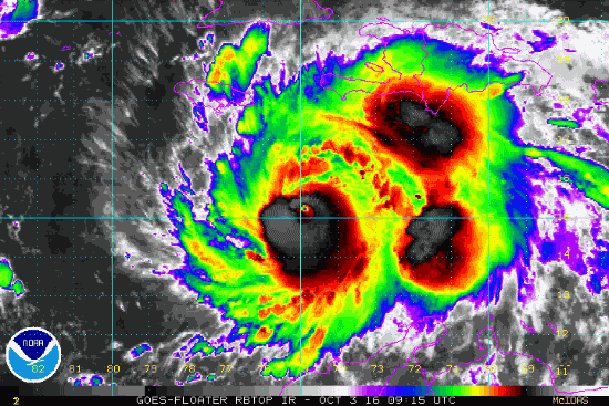
UPDATE: Oct. 3, 2016, 9:01 p.m. EDT Hurricane Matthew intensified slightly as it moved closer to landfall in western Haiti on Monday night. While hurricane hunter aircraft found maximum sustained winds were still at 140 miles per hour, the storm's minimum central air pressure had dropped from earlier in the day, which indicates intensification. In addition, the storm has slid a bit northeast of due north, which puts more of Haiti at risk from the worst of its rains, winds and storm surge.
This is unwelcome news for a country where thousands of people will be riding out the storm in temporary shelters with scant protections against hurricane force winds and flooding rains.
Powerful Hurricane Matthew is moving north toward Haiti, Cuba and eventually the Bahamas, bringing with it the triple threat of storm surge flooding, several feet of rain and damaging winds.
The nation of Haiti, the poorest country in the Americas, is in line for an extremely rare and extremely dangerous event: A Category 4 storm making landfall while moving from the south to north across part of the nation. The closest analog to Hurricane Matthew is Hurricane Hazel in 1954. Hazel also struck western Haiti, and it killed about 1,000 people there.
The storm's angle of approach matters because it affects where the strongest winds, rains and storm surge are directed.
SEE ALSO: Watch as powerful Hurricane Matthew heads toward Haiti and Jamaica
In this case, southern Haiti stands to receive up to 40 inches of rain from Hurricane Matthew, as onshore winds pile up air along mountain slopes, according to the National Hurricane Center (NHC). Extremely heavy rainfall is also likely in the southwestern Dominican Republic.
The rainfall in Haiti will create a risk of mudslides in a nation still recovering from a devastating 2010 earthquake, which displaced 1.5 million people. The combination of steep mountain slopes and deforestation makes Haiti vulnerable to deadly mudslides from heavy downpours unconnected to hurricanes, let alone full-fledged major hurricanes like Matthew.
According to the NHC, hurricane conditions with sustained winds of at least 74 miles per hour are expected to reach Haiti on Monday night with eastern Cuba and the southeastern Bahamas getting hit on Tuesday.
A damaging storm surge of 7 to 11 feet above normal tide levels is forecast for the southern coast of Cuba east of Cabo Cruz, with a similar surge predicted for the south coast of Haiti. In the central and southeastern Bahamas, a storm surge of 10 to 15 feet is predicted. In advance of the storm, the U.S. Navy has been evacuating non-essential personnel from its base in Cuba's Guantanamo Bay.
The storm's center is expected to pass to the east of Jamaica, which puts the island nation on its weaker western side. However, even there, up to nearly 2 feet of rain may fall, with a storm surge of up to 4 feet above normal tide level, according to the NHC.
G-IV flights starting every 12 hours this afternoon (instead of 24 hours) to help determine the threat of #Matthew to the US East Coast pic.twitter.com/eq1fossy6t
— Eric Blake (@EricBlake12) October 3, 2016
Over the weekend, Hurricane Matthew underwent an extraordinarily rapid period of intensification, leaping from a tropical storm to a Category 5 hurricane in just 36 hours.
It has since maintained Category 4 status, and is forecast to remain a powerful "major" hurricane of Category 3 or greater through Thursday morning. However, hurricane intensity forecasts have a greater uncertainty than track forecasts do, and the storm's interactions with land masses, such as Haiti and Cuba, could weaken it more than is currently forecast.
Where will Matthew go after the Bahamas?
The big question facing U.S. weather forecasters the next few days is where Hurricane Matthew will head after it emerges from the Bahamas.
The National Weather Service has been going to extraordinary lengths to try to answer that question, launching extra weather balloons from every East Coast facility it operates in an effort to gather more data to feed into computer models. In addition, the agency has been consistently flying a specially outfitted Gulfstream jet, nicknamed "Gonzo," ahead of Matthew to sample the atmospheric steering currents that will affect the storm's intensity and movement. That data, too, is being fed into computer models to improve their projections.
As of Monday at noon ET, computer models were projecting that Hurricane Matthew would parallel the East Coast of the U.S., potentially making landfall along the Outer Banks of North Carolina or even in South Carolina, and also threatening New England in about five to seven days.
GFS 12z landfalls Hurricane Matthew in 5-days in South Carolina. ECMWF 00z was also perilously close to SE US coast. Keep watch! pic.twitter.com/taUwPxDVQX
— Ryan Maue (@RyanMaue) October 3, 2016
However, uncertainty is still high, largely because the models are having a hard time agreeing on how large-scale weather features will evolve that will help steer Matthew as it approaches the U.S.
U. S. East Coast: find out today if you live in an evacuation zone. If so, decide where you’d go, how you’d get there if told to go #Matthew
— Dr. Rick Knabb (@NHCDirector) October 3, 2016
As the NHC stated at 11 a.m. ET on Monday, "direct impacts in Florida cannot be ruled out. In addition, it is still too soon to determine whether, or how Matthew could affect the remainder of the U.S. east coast."
