Hurricane Madeline poised for 'dangerously close' encounter with Big Island of Hawaii
Hurricane Madeline is closing in on the Big Island of Hawaii and could become the first such storm to make landfall there in recorded history at around 8 p.m. HST on Wednesday.
Regardless of whether the storm's center of circulation crosses the southern portion of the island, the Big Island will still see damaging waves, high winds and heavy rainfall. Schools are closed island-wide on Wednesday and Thursday, with a hurricane warning in effect for all of Hawaii County.
SEE ALSO: NASA flies over 3 hurricanes in one day and makes amazing time-lapse video
Fortunately for residents of the Big Island, Madeline — which was once a formidable Category 3 storm — has weakened considerably since Tuesday.
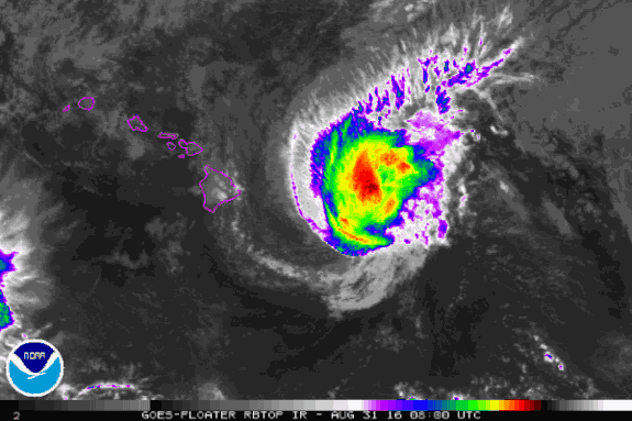
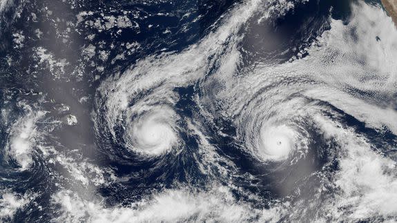
Image: noaa
The National Hurricane Center pinned the weakening on hostile upper level winds that are causing the storm to tilt vertically, like a wobbly spinning top, sapping its ability to maintain a clear eye and vigorous thunderstorms surrounding it.
In a forecast discussion, the Hurricane Center described the wind shear that the storm is being exposed to as "debilitating," since it is causing the storm to sputter and steadily weaken.
Nevertheless, the storm should still be either a strong tropical storm or a Category 1 hurricane when it makes its closest pass to the Big Island.
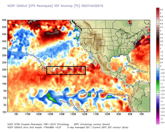
Image: weatherbell Analytics
The Hurricane Center says the track will bring the storm "dangerously close" to the Big Island.
The east and south facing portions of the island will likely take the brunt of the storm, in the form of the fiercest winds, highest waves and biggest storm surge.
The National Weather Service in Honolulu is warning of surf building to as high as 25 feet on Wednesday afternoon and evening, local time, with 1 to 3 feet of storm surge.
"The combination of storm surge and wave runup may cause significant coastal flooding and damage to coastal properties and infrastructure, including roadways," the NWS said.
Mauna Kea, a volcano that towers to a height of 13,800 feet, is likely to see winds approaching 100 miles per hour, according to the NWS in Hawaii.
Heavy rainfall could also cause mudslides, with up to 15 inches of rain expected to fall, particularly in higher elevation areas of the island.
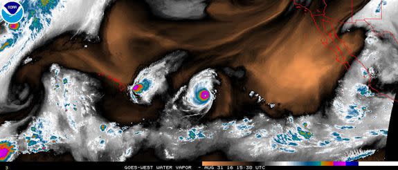
Image: noaa
The hurricane is not expected to hit Honolulu or severely impact the other islands, although tropical storm-force winds and squalls may overspread parts of Maui.
President Obama is expected to fly to Honolulu on Wednesday night to address a summit of Pacific Island leaders. It's not clear if the storm will affect Air Force One's journey to the islands.
Ironically, the speech is expected to focus on Obama's record combating climate change. Part of what is enabling this hurricane to reach Hawaii on an east-to-west track is unusually mild ocean temperatures, which have been attributed to human-caused global warming as well as natural climate variability.
Hurricane Lester is hot on Madeline's heels
Once Hawaii finishes dealing with Hurricane Madeline, the focus will turn to major hurricane Lester. As of Wednesday morning, Lester was a Category 4 storm moving from east to west, closing in on Hawaii.
It is forecast to pass near the Hawaiian islands between Saturday and Monday as a minimal hurricane, weakening to a tropical storm as it moves over or close to the state.
Even if that storm misses the islands to the north, it still poses significant risks from high winds, heavy rain and damaging surf, with forecast uncertainty remaining high regarding the storm's intensity and exact track several days in advance.
Hawaii is becoming more hospitable for hurricanes
Hawaii has long been hostile territory for tropical storms and hurricanes that move from east to west, since ocean temperatures usually drop below levels that can sustain such powerful storms close to Hawaii.
In other words, ocean temperatures have served as Hawaii's hurricane force field, as demonstrated by the fact that the Big Island has never been hit by such a storm since reliable records began in that part of the Pacific in 1949. (The island has, however, been struck by tropical storms.)
Most damaging tropical storms that hit the Hawaiian islands curve northward from warm waters to the south of the islands. This was the case with Hurricane Iniki in 1992, for example, which devastated Kaui.
Interestingly, Hurricane Madeline is weakening due to an inhospitable upper level winds, not cool ocean temperatures.
A study published last year in the Bulletin of the American Meteorological Society found that human-caused global warming is likely raising the risk of more active hurricane seasons in the Hawaiian islands.
