Will Hurricane Lee turn and miss the East Coast? Latest NHC forecast explained.
Millions of people are anxiously waiting to see what Hurricane Lee will do in the coming days as it approaches the U.S. coastline.
For days, Lee's forecast track has appeared to be aimed in the direction of the East Coast, even as the storm rapidly strengthened into a Category 5 hurricane. But there's good reason to believe Lee won't continue in a straight line: Some routine weather systems are expected to save much of the East Coast from catastrophe.
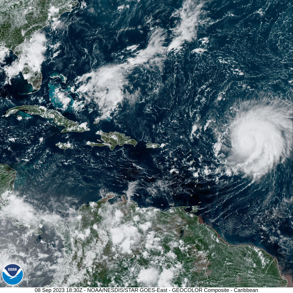
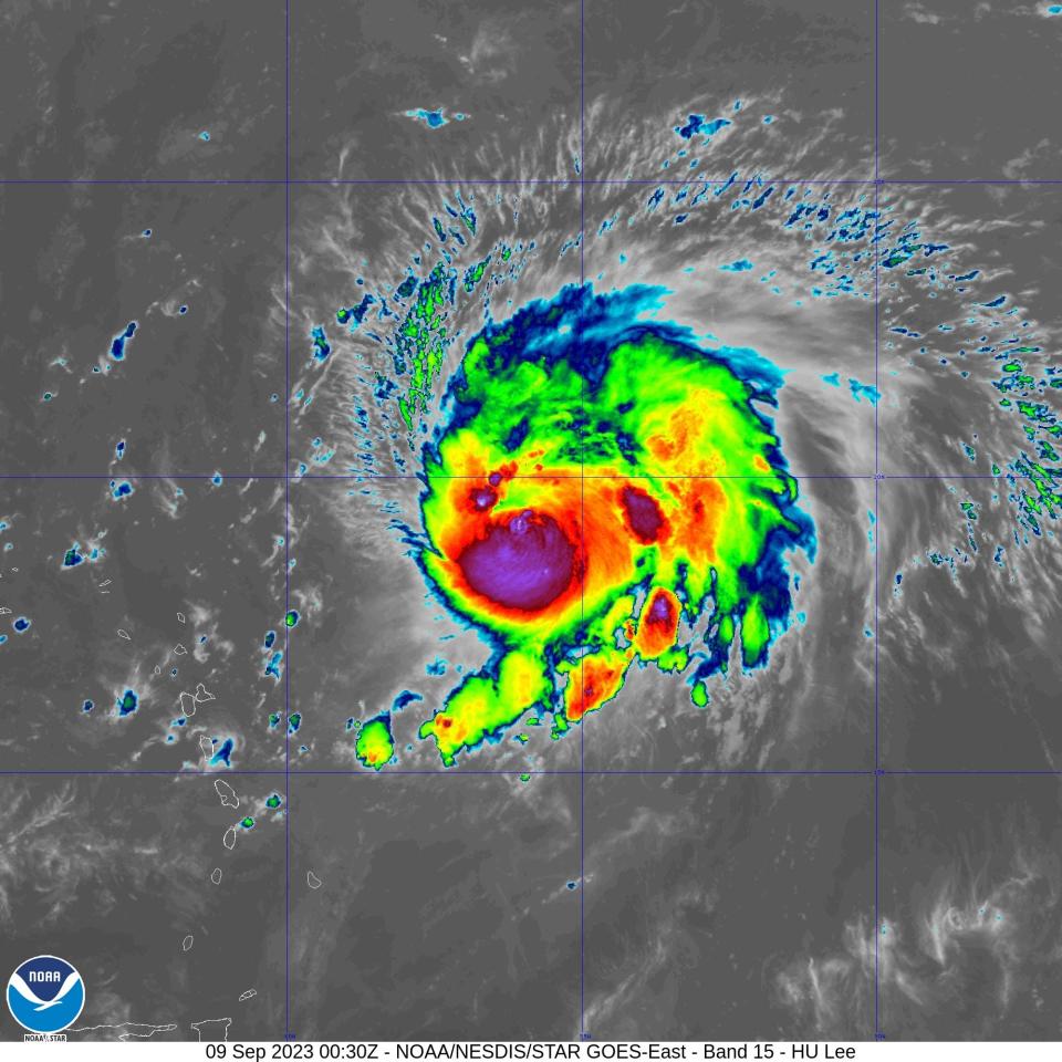
As of Saturday evening, Lee was moving west-northwest ‒ roughly in the direction of the United States ‒ at 10 mph as a Category 3 hurricane. The storm is still hundreds of miles out to sea and had weakened slightly, but forecasters said it was likely to strengthen again.
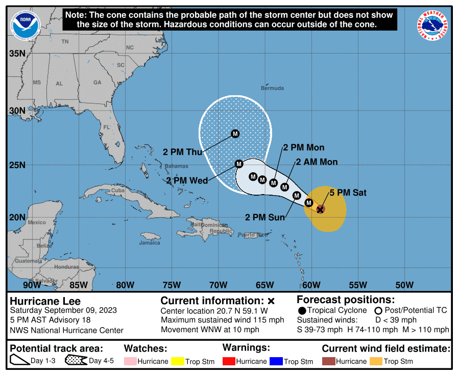
A 5 p.m. forecast cone from the National Hurricane Center showed that forecasters expect Lee to begin to turn sometime around Wednesday, moving northward roughly parallel to the East Coast, still well off shore. The forecast cuts off as the storm is expected to make that turn.
Jamie Rhome, deputy director of the National Hurricane Center, understands the concern when a massive hurricane appears to be barreling toward the United States. "People want a yes or no answer – Is it coming, is it not coming?" Rhome said Friday. But this far ahead of a storm – Lee was still hundreds of miles east of the Leeward Islands – "science doesn't let you directly answer that question."
The long-range forecast into next week hinges on the interactions between several key weather systems over the next few days: the hurricane, a high pressure ridge that expands and shrinks across the western Atlantic Ocean that often steers hurricanes and a southward dip in the jet stream that will push a low pressure area toward Lee.
Highly advanced forecast models help meteorologists understand the potential interplay between these large atmospheric systems, but uncertainty remains, Rhome said. "That's why we can’t say there will or won’t be direct impacts to the Northeast U.S. Coast and Canada."
"Right now, save the rip current risk, which is extreme, there’s no reason for people on the East Coast to be fearful," he said. "We need them to be informed and aware and check back for details."
What's the risk to the East Coast right now?
"Florida is in all likelihood out of the direct impacts of wind and rain, but still very much in the crosshairs of rip currents," Rhome said.
Much of the rest of the U.S. East Coast could be spared direct impacts beyond rip currents, rough surf and erosion, but it's too soon to say for sure.
Coastal residents in the northeastern U.S. and Canada need to remain alert and regularly check the forecast. Direct impacts to those areas may be the biggest unknown at this early stage.
Visual How rip currents endanger swimmers
Where is Hurricane Lee?
By 5 p.m. Saturday, Lee was about 310 miles northeast of the northern Leeward Islands, moving west-northwest with maximum sustained winds of about 115 mph, the National Hurricane Center said.
Will Lee turn to the north?
Everything depends on these large-scale weather patterns that are constantly in motion in the upper atmosphere, said David Nolan, a professor of atmospheric science at the University of Miami’s Rosenstiel School.
“Right now, every computer model is showing there’s a big dip in the jet stream over the United States that seems very likely,” Nolan told USA TODAY on his way to catch a flight to St. Croix for a hurricane hunter flight on Saturday. If that occurs, Lee will be pulled northward.
One way to understand what happens is to think of Atlantic hurricanes as a storm river running north between two enormous mountain ranges. The ranges are the high pressure ridge in the mid-Atlantic and the trough of low pressure pushed by the jet stream.
“It’s a squeeze play,” said Andrew Orrison, a meteorologist at the National Weather Service Weather Prediction Center in College Park Maryland. “These storms track along the path of least resistance.”
These otherwise routine weather systems are expected to save much of the East Coast from catastrophe.
For the next few days, the Atlantic high pressure will drive Lee along its southern edge, AccuWeather senior meteorologist Alyson Hoegg told USA TODAY. By Wednesday and Thursday, the low pressure area moving across the eastern U.S. will come into play.
By week's end, Hoegg said, winds associated with the two systems will work together to drive Lee toward the north. The publicly available model plots indicate a north or northeastward turn is likely to take place somewhere east of the Bahamas.
Could Hurricane Lee surprise forecasters and keep going straight?
Not likely. Twenty years ago the influence of the jet stream and other atmospheric conditions might have led to last-minute surprises, but not today, Nolan said.
“Once upon a time when the models were not as good, there could be surprises,” he said. “The capability of the computer models over periods of 5-10 days has just been increasing steadily for the last 20 years. We know with near certainty Hurricane Lee is going to turn to the north."
A colleague of Nolan's also pointed that out in a post on X on Friday.
"This isn't 1990 anymore," said Andrew Hazelton, an associate scientist with the University of Miami and the National Oceanic and Atmospheric Administration's Cooperative Institute for Marine and Atmospheric Studies.
"Global models are solid," said Hazelton, who flew into Lee on Friday. Forecasters have added confidence because the models remain in consensus about Lee's northward turn, but it could be to the left or right a couple of degrees.
Too soon to know impacts to New England
While it’s too early to know how close Lee might come to the U.S. East Coast, New Englanders are keeping a wary eye on the storm as some models have projected it tracking perilously close to New England – particularly Maine. It has been 69 years since a major hurricane made landfall in New England, said Brian McNoldy, a scientist and hurricane researcher at the University of Miami.
On Sept. 8, 1869, a Category 3 hurricane known as “the September Gale of 1869” struck Rhode Island, the National Weather Service in Boston noted on Friday. The storm cut all telegraph lines between Boston and New York and capsized a schooner, killing 11 crew members.
“If Lee actually does make landfall in New England, there’s no doubt the storm surge would be a huge threat,” he said.
Hurricane center's forecast track for Lee
The official forecast track cone shows the most likely path of the center of the storm, not the full width of the storm or its potential impacts. The center of the storm is likely to travel outside the cone up to 33% of the time.
What the spaghetti model plots show
Model plot illustrations include an array of forecast tools and models, and not all are created equal. The hurricane center uses the top four or five highest-performing models to help make its forecasts.
Contributing: Doyle Rice, USA TODAY; The Associated Press
This article originally appeared on USA TODAY: Hurricane Lee path from NHC explained: Will powerful storm miss US?

