Tropical Storm Idalia moved out of Florida. Where is it going now? What the track shows
Tropical Storm Idalia will be moving back into the Atlantic Ocean as soon as it moves over the Carolinas — putting Florida in the rear-view mirror.
Idalia’s center will be moving along or near South Carolina’s coast through Wednesday night, after it made landfall near Keaton Beach on Florida’s west coast as a Category 3 hurricane in the morning, according to the National Hurricane Center’s advisory at 8 p.m.
The system may bring some low storm surge to Florida but the majority of strong, dangerous weather accompanying Idalia that was plaguing the state is now gone.
However, coastal communities along Florida’s Gulf Coast were still flooded in the aftermath.
So, where is Idalia now? And where is it going?
Here’s what the forecast track shows:
Where is Idalia now? And how strong is it?
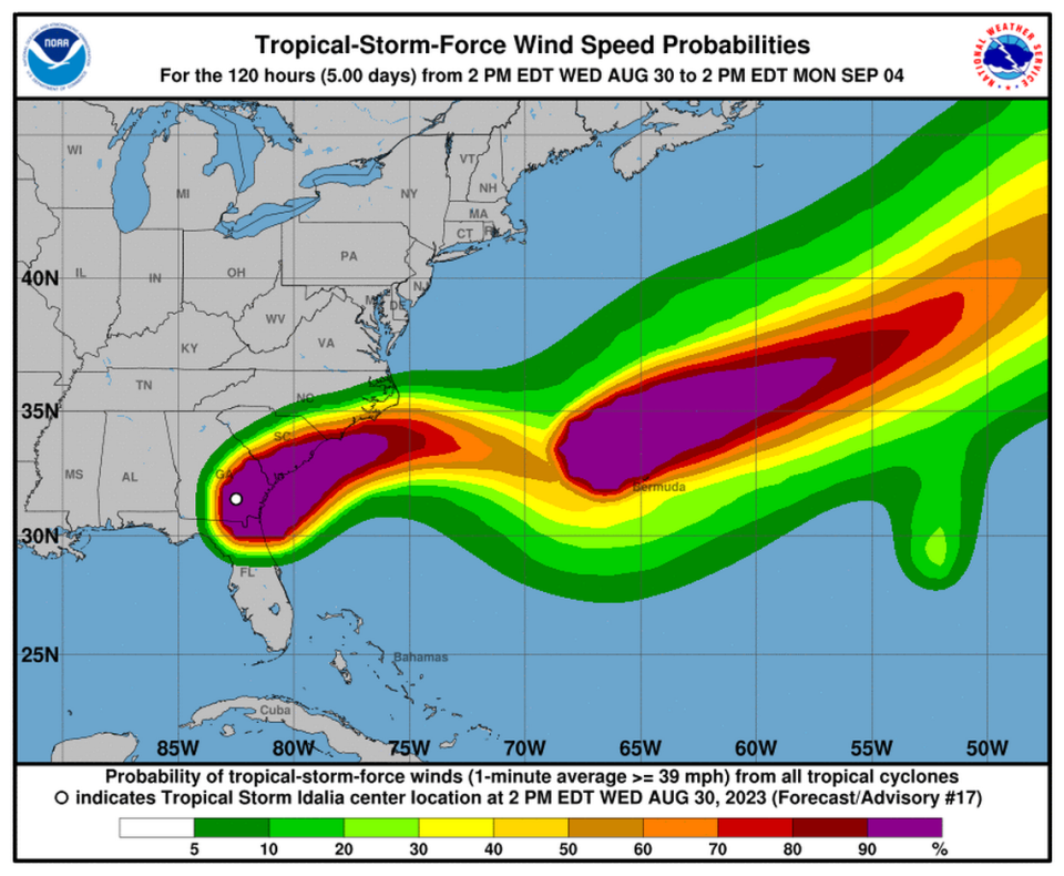
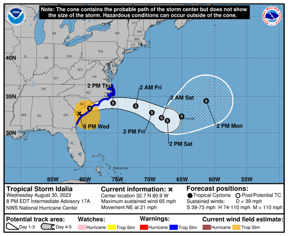
Tropical Storm Idalia was about 60 miles west of Charleston, South Carolina, with maximum sustained winds near 65 mph, the 8 p.m. advisory said.
Tropical storm-force winds extend up to 205 miles.
Where is Idalia going?
Idalia already dashed out of Florida and Georgia earlier in the day and is still traveling northeast at 21 mph, according to the hurricane center.
The forecast track shows Idalia moving along South Carolina’s coast before it heads just offshore of North Carolina on Thursday. It will then move east into the weekend.
On top of that, the storm will continue weakening as it moves over land Wednesday night. However, once the center returns to the Atlantic, it may interact with some stronger winds — which increases the difficulty of predicting its intensity past that point.
Idalia could become post-tropical but because of the uncertainty the hurricane center is keeping it as a tropical storm through the next five days.
What type of weather will it bring?
A look at the weather:
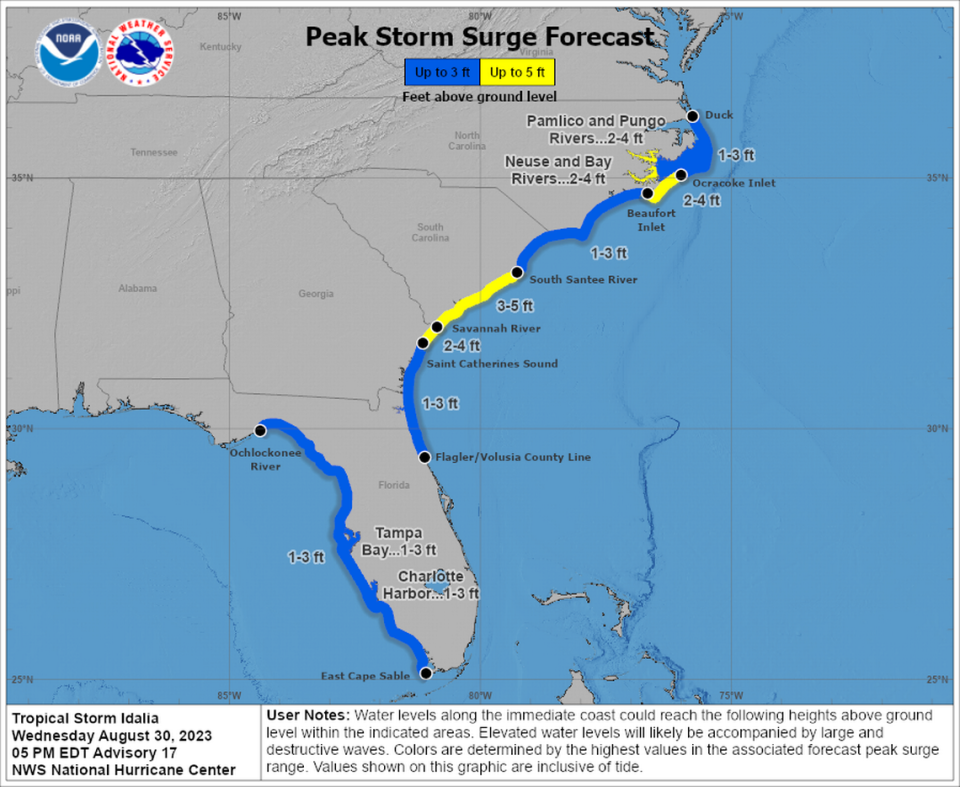
Storm Surge: Forecasters discontinued the storm surge warnings and watches along Florida’s Gulf Coast and Georgia’s coast. However, a warning and watch remains for the Carolinas.
“The deepest water will occur along the immediate coast in areas of onshore winds, where the surge will be accompanied by large waves,” the hurricane center said.
Winds: Tropical storm conditions are expected to continue along the northeastern coast of Georgia and South Carolina through Thursday. These winds will spread into North Carolina Wednesday night.
Rain: Idalia is forecast to bring 4 to 8 inches of rain, with some isolated areas seeing up to 10 inches of rain from east-central Georgia through central to eastern South Carolina and eastern North Carolina into Thursday. Flash, urban and moderate river flooding, with “considerable impacts,” will be possible.
Hurricane Idalia watches and warnings
Tropical storm warning: Volusia/Brevard County Line to the North Carolina/Virginia border; Pamlico and Albemarle Sounds
Storm Surge warning: St. Catherine’s Sound Georgia to South Santee River South Carolina.
Storm Surge Watch: Beaufort Inlet to Ocracoke Inlet, North Carolina; Neuse and Pamlico Rivers, North Carolina

