History: Little-known desert history of the Bradshaw Trail
The humble contribution of a scarce book by Francis J. Johnston entitled “The Bradshaw Trail” to the Palm Springs Historical Society was important. The book preserves a largely unknown part of the history of the Coachella Valley. Thoughtfully gifted by Bud Hoover — who has contributed to the entire desert in myriad ways, small and large — the little volume chronicles the taming of a daunting expanse of land, the New Mexico and Arizona Territories, which separated civilization on the East Coast and the emerging settlements of Southern California at the end of the 19th century.
Johnston explains it was “wild, barren and lonely, consisting of endless desert and great mountains. The white man found the land inhospitable and repelling. They looked upon its Indian cultures and civilizations as exotic, unpredictable and often very efficiently warlike.”
For centuries, the land was traversed by Indian tribes. The Spanish began colonizing it in the very early 17th century, unbeknownst to the fledgling settlers at Plymouth Rock. But the unforgiving desert prohibited any real connection or travel between Santa Fe, New Mexico, and San Bernardino, California, until enterprising frontiersmen blazed a trail.
Johnston explains: “By the 1820s this virtual ‘no-man’s land’ — free abode of the aboriginal American — was being penetrated by scouts and explorers of the eastern seaboard civilization. ... mountain men and trappers wandered into and out of Arizona, following no real route. A few ... came on to California and settled there under the Mexican regime. After the war with Mexico, still more Americans made their precarious way into this land which was without government and scarcely had legal status as part of the United States.”
The discovery of gold in Northern California made for through traffic en route to the gold fields. Southern cities promoted the overland passage for the commerce it brought along with it. According to Johnston: “New Orleans, Shreveport, San Antonio, Corpus Christi and Houston, Texas, all encouraged or sent parties overland to California by the southern route” from Santa Fe westward following old wagon trails.
But in early 1862, in the midst of the Civil War, the New Mexico and Arizona territories were a wild, untamed land.
William Bradshaw had come to California in the Gold Rush of 1849 to find his fortune. Realizing that the strike was playing out, in June 1862 he gathered a party of adventurers and headed eastward from Los Angeles to a rumored new discovery of gold in La Paz ahead of what he anticipated would be another rush for gold and the boom that might make him wealthy.
Johnston writes that the effect was to “awaken this virtually undisturbed giant of raw wealth. The route they followed, the trail they broke, has become firmly and rightfully named The Bradshaw Trail. From its inception, central Arizona became accessible to California. By 1864 the California connection had been extended eastward into New Mexico. By the end of the Civil War, the link was complete to the eastern states. Bradshaw had, in fact, opened Arizona and joined it to the United States.”
The route began in San Bernardino, California, through great Banning plateau that included Highland Springs, Gilman Ranch and Whitewater, through the San Gorgonio Pass to Agua Caliente, current day Palm Springs. Bradshaw established stagecoach stations every 15 to 30 miles or so.
“Palm Springs, called Sexhi by the Cahuilla and Agua Caliente by the Spaniard and Mexican, had an important stop built of adobe ...”
The earliest accounts mark the next stop at Sand Hole, an unreliable watering spot on the trail beyond Agua Caliente in what is now Palm Desert.
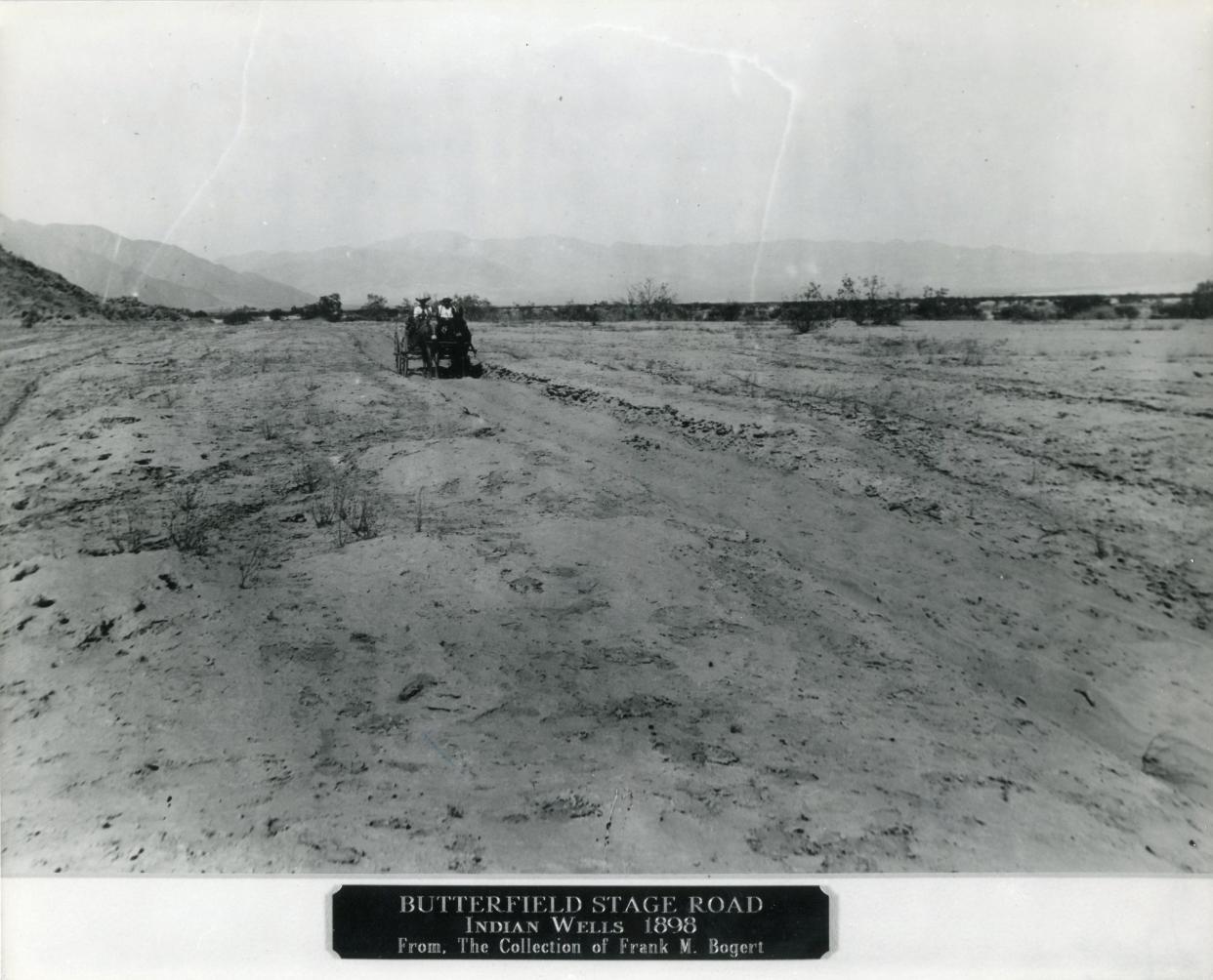
The route trekked eastward toward Point Happy. “Indian Wells was just that. First called Old Rancheria on the maps, it was originally a Cahuilla village, and the present name developed from the known presence of a deep well dug there by the Indians ... where a permanent station was built of stone and adobe.”
Probing further eastward to the Salton sink, the depression that would become a sea by the escape of the Colorado river from its banks some four decades later, Bradshaw was befriended by Cabazon a Cahuilla chief and a visiting Maricopa Indian from Arizona who shared their knowledge of the ancient trade routes through the Colorado Desert and the location of springs and water holes, where Bradshaw would establish stations.
From the sink, Bradshaw pressed on. “Meandering on around the jutting Santa Rosas the road reached Toro Spring at the mouth of Toro Canyon. This area was heavily occupied by Desert Cahuilla, and their villages were found throughout it. Cabazon lived here. ... Another permanent station was established here. ... It is listed as Toro Mail Station in one table. The name Martinez, that applies to part of the Indian Reservation which includes this section came from Martin’s House, a part of Toro Village ...” The road went on to “Palma Seca, a place of bitter water that could not be used for men or teams” recorded as "Bitter Spring" on some maps.
The trail continued through the Orocopia and Chocolate Mountains to Dos Palmas, a lush oasis a few miles east and south of Palma Seca. “It has been in use as a way point since prehistoric times. The ancient Cahuilla-Maricopa trail passes through this grove as it follows the mesas and desert pavement from Tucson to San Bernardino Valley. From the abundance of artifacts and potsherd still scattered through the swamp grass and among the gravel on the periphery of the grove, it appears that the early Cahuilla not only passed through but often stayed in semipermanent camp.”
Further, Canyon Spring, Chuckwalla Well, Mule Spring, Laguna and Willow Spring station stops were established until the arduous trail finally encountered the mighty Colorado River. Here, Bradshaw built a ferry to shuttle gold miners across the river. On Nov. 7, 1864, the territorial legislature permitted the ferry to charge $4 for a wagon and two horses, $3 for a carriage and 1 horse, $1 for saddle horse, $.50 for a man afoot, $.50 per head for cattle and horses, $.25 per head for sheep.
Two-hundred fifty miles east of Los Angeles in La Paz there was gold. The inevitable exodus of miners and fortune-seekers from Northern California would now follow, availing themselves of Bradshaw’s trail, stagecoach and ferry. Other companies, like Wells Fargo, leisure travelers and traders in all sorts of goods began using the trail and, having no alternative, were obliged to use Bradshaw’s expensive ferry service across the river.
By 1870, the gold at La Paz was pretty well exhausted, but the trail remained a vital connection through the southwest desert. Much of the route would be paralleled by the interstate highway in the 20th century, speeding motorists from Blythe to Los Angeles, blissfully unaware of the fortitude and ingenuity it took to find the way.
To explore a bit of the unpaved trail and cultivate an appreciation for the remarkable feat of William Bradford, hire on Evan Trubee of Big Wheel Tours, bwbtours.com, for a special outing on the very desert Bradshaw traversed and tamed.
Tracy Conrad is president of the Palm Springs Historical Society. The Thanks for the Memories column appears Sundays in The Desert Sun. Write to her at pshstracy@gmail.com.
This article originally appeared on Palm Springs Desert Sun: History: Little-known desert history of the Bradshaw Trail

