Heavy rain to renew flood concerns across Ohio, Mississippi valleys into Tuesday
Areas of the Ohio and Mississippi valleys that got hit hard with downpours last week will face renewed flooding dangers into Tuesday.
The same storm system threatening the Midwest and Northeast with significant snow and ice early this week is unleashing soaking rainfall across its southern side.
Enough rain is expected to fall to aggravate the flooding situation from Arkansas, Tennessee and Kentucky, to the southern portions of Missouri, Illinois, Indiana and Ohio.
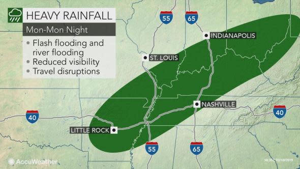
"This system can produce 2-4 inches of rain, which can lead to flash flooding," said AccuWeather Lead Long-Range Meteorologist Paul Pastelok.
There can be an AccuWeather Local StormMax™ of 6 inches in areas that get hit with repeated downpours.
Water levels can increase on rivers that are already running high from last week's deluge.
New streams and rivers may also begin to flood as the rain runs off the already saturated ground.
Those living in low-lying, unprotected areas should make sure they keep a close eye on the weather situation and heed any evacuations that are ordered by local officials.
Download the free AccuWeather app to stay aware of the latest flooding dangers in your area.
Motorists on stretches of interstates 40, 55, 64, 65, 69, 71 and 75 will face reduced visibility from the downpours and blowing spray from other vehicles. Ponding of water will add an increased risk of hydroplaning while traveling at highway speeds.
Turn around and find an alternate route if you encounter a roadway that is flooded.
In addition, there can be a heavy band of thunderstorms with localized severe weather, according to Pastelok.
Thunderstorms with locally damaging winds can rumble through the lower Mississippi Valley on Monday night before targeting the Southeast on Tuesday.
The region will only get a couple days of dry weather before the next storm arrives at late week.

